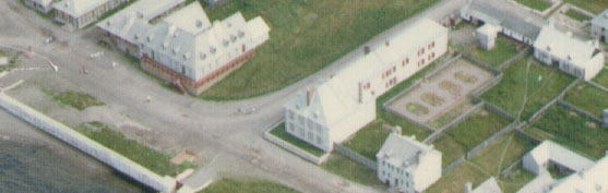
Bigotyard
Website Design and Content © December 14, 2001, by
Eric Krause, Krause House Info-Research Solutions
(© 1996)
All Images © Parks Canada Except
Where Noted Otherwise
Researching the
Fortress of Louisbourg National Historic Site of Canada
Recherche sur la Forteresse-de-Louisbourg Lieu historique national du Canada
Fortress of Louisbourg, Block Two,
Lots F/G/H Properties:
Landscape Arrangements as of 1744
The Author's Conclusions
Summary of Relevant Yard Features Required for an Understanding of the Block 2, Lot F/G/H Landscape Design just prior to the Siege of 1745
Introduction
The summer of 1744 is the year and season which the Fortress of Louisbourg has chosen for its interpretative focus. In years past, when deciding to reconstruct assets to that date - including landscape features - it was often found that other 18th-20th century "as founds" also once occupied the same space, but at a different time. With this revelation there understandably arose the perplexing, and sometimes very controversial question, whether to destroy or to preserve such "intrusions" when in conflict with the date of the interpretative focus. While this report will assuredly generate similar questions, the decision what to do will be left - I assume as it was in the past - either to the discretion of the time proven, formalized team or committee process known as Structural Design and/or Period Presentation, or, if gridlock, to senior management as final arbitrator.
This report merely presents the case for the summer of 1744. If the decision is to preserve certain existing "intrusions," then the Fortress of Louisbourg will need to determine the required mitigating actions. Already, some major mitigations have taken place - for example, the placement of the protective, preservation padding over the "as founds" of the so called 1754 Lot H Prévost Addition [Lot H Prévost Addition - Archaeology: B-1A-1-5.] While reversing such actions may or may not be possible, or even desired, this report will simply present the case for 1744 without reference to such safeguards, or to whether or whether not they are desirable.
--------------------------
The Current Situation
By year's end, 1978, the yards of Lots F, G and H - the property of the Commissaire-Ordonnateur - were finally completely excavated:
"Both the yard and the house were completely excavated. In fact , some 2194 square meters of area was excavated. The only materials that are still in place are the remains of architectural features, such as the Prevost addition foundations, wells etc." [For more details on this discussion in the minutes, click here and go to B 333, June 19, 1990]
Afterwards, in 1980, Yvon LeBlanc produced the first garden and yard plan, but, in part, because of an incomplete interpretation of the historical record, he was compelled to heed certain property mitigations required to protect specific archaeological assets - and thus, his decision was to construct the garden above grade as illustrated on the approved proposal reproduced below:
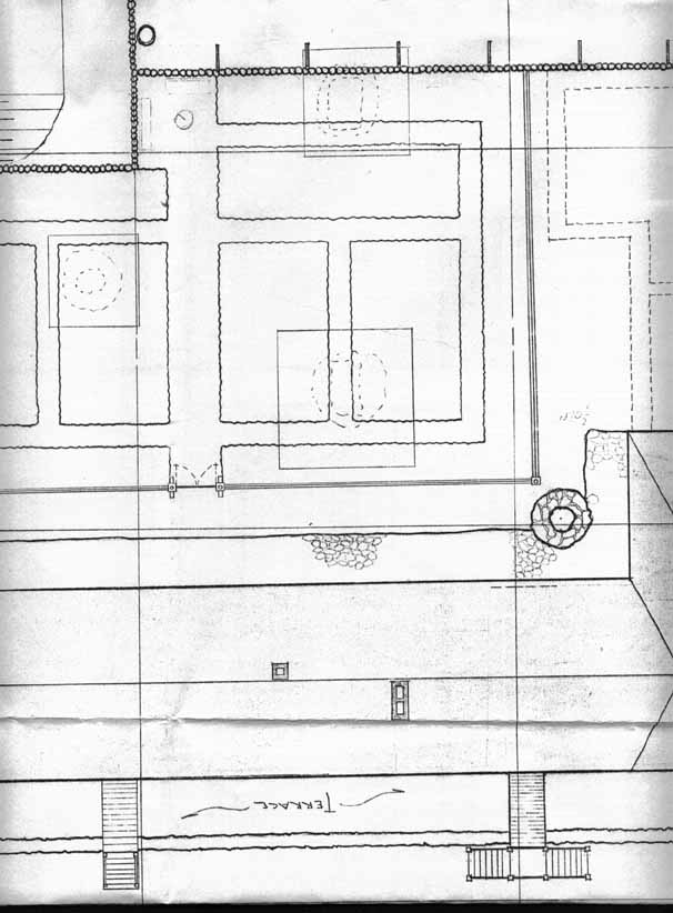
The
Approved Layout
[Please
click on an image to enlarge it]
|
|
|
|
|
Stable Yard Area |
Garden Area |
Residence Area |
|
|
|
The Garden |
Years later, a submission [Click here and go to B 330, May 04, 1988] was made not only to alter the design of the garden to satisfy the reservations of a professional landscape architect, but also to respect the existing mitigations because the interpretation of the historical record remained inadequate. This information gap has continued until the present day.
--------------------------
Interpretative
Talking
Points and Recommendations for the Case
for the Summer of 1744
Introduction
The following interpretative talking points and recommendations are made available so that the Fortress of Louisbourg can confidently produce a landscape design reflective of the summer of 1744 with all the known facts entered into its decision making process, be it structural design, period presentation, or management edict. Affecting this process will also be the following considerations: historical accuracy to the greatest extent possible, mitigations protective of archaeological assets, and historical compromise needed to meet modern requirements. From this volatile mix one day a new landscape design will hopefully emerge.
------
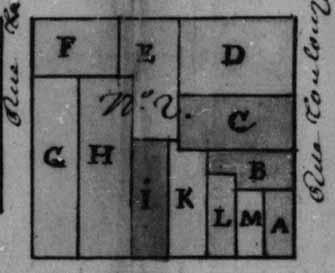
Property
Map (From Vallée - 1734-5) Illustrating
the General Block Two Lot Location of
Each Interpretative Talking Point
[Please click on the image to enlarge it]
 |
(©
Archives Nationales (Paris, France),
Outre-Mer, Dépôt des Fortifications et des Colonies, IV
- 183 and
for the exclusive use by the Fortress of Louisbourg for research purposes only)
Although Lot G would capture both Lot F (c. 1734-1736) and Lot H (1741), this report has combined the original lot designation (F, G, or H) - as illustrated on the above plan - with their more precise archaeological designation - as illustrated on the plan below - to better visualize in the mind of the reader the geographic location of each interpretative talking point and its recommendation.
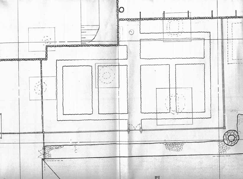
Property
Map Illustrating
the Exact Archaeological Location of Each Talking Point
(Note:
Where a designation was unavailable in an archaeological report,
it has been calculated from readily available archaeological site plans.
Revisions to make these calculations more accurate are welcome.)
[Please
click on an image to enlarge it]
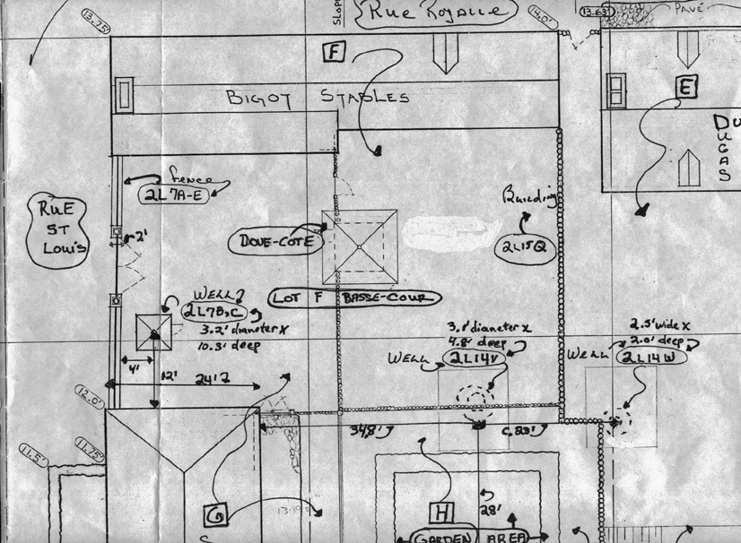 |
Stable |
 |
Garden |
 |
Residence |
------
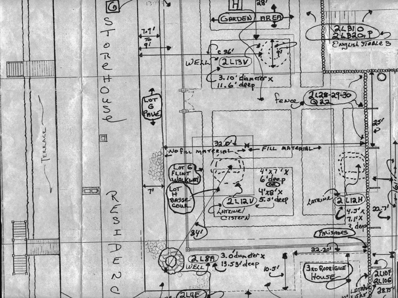
[Please click on an image to enlarge it]
 |
|
Complete
Plan - |
 |
|
|
1739
Situation - |
Proposed
new |
(©
Archives Nationales (Paris, France), Colonies,
C11A, Volume 126, folio 229 and
for the exclusive use by the Fortress of Louisbourg for research purposes only)
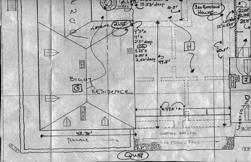
One of the keys to an understanding of the development of this property is to accept the general accuracy of the 1739-5 plan, as well as the fact that on the Lot F/G/H property complex, Archaeology has identified four period (1713-1758) latrine locations of which only two they have positively identified as such: the combined Lot G and Lot H 2L4E Latrine complex, as well as the Lot H 2L12H latrine. The other two are but possible candidates: the Lot H 2L12V cistern/latrine. and the Lot H 2L14V well.
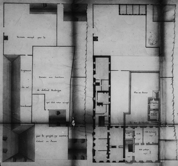
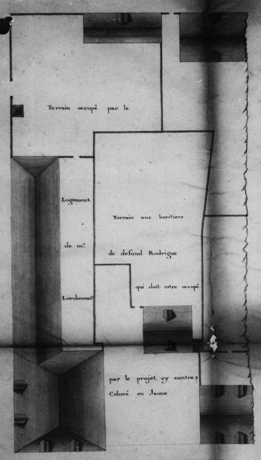
Plan 1739-5 accurately illustrates known documentary facts that either prove or suggest other facts. For example, some known facts were: the existence of a Lot G passageway 4 pieds wide by 46 pieds deep, a Lot H 3rd Rodrigue house that measured 22 pieds x 22 pieds, and a Lot H property that along the Quay measured 44 pieds (each dimension is based on the detailed, notarized 1741 sale agreement.) From these indisputable facts we can determine and interpret other facts: for example, that the reason for the jog just beyond the south wall of the Lot G residence was to allow Lot G access to his new 2L4E latrine; or, that the general scale on the plan is relatively accurate (and can be used) since it compares favourably with the measurements of the notarized sale.
Significantly for this report, plan 1739-5 gives detailed visual form to a Lot H property that the sale contract described as 44 pieds wide x 150 pieds deep (both the general scale and the 22 pieds and 44 pieds scale sets - described above - confirm this depth.) Not surprisingly, this property deviates visually in precise detail from the general town property plan (1734-5) which Vallée issued in 1734, for that was not the goal of the general plan. That precise detail was for the individual property plan that an owner sometimes asked of surveyor Vallée to produce.
The 1739-5 plan also visualizes for us several of the results of earlier, well-documented property fights between the owners of Lot G, Lot H and Lot I, as well as the reason why a skewed building once existed in the interior of Lot E - which events Brenda Dunn has, in great detail, described (and illustrated with historical plans like 1723-1 for the skewed building) in her two reports Dunn, 1969 - Lot G / Dunn 1971 - Lot H and Lot E. For example, the 1739 plan clearly illustrates that the west boundary line not only suddenly veered off a number of degrees to the right (westward) near the meeting spot of the Lot E/I boundary fence - reflecting the interior property remnants of the original skewed fence line that existed prior to the c. 1725 re-alignment of the Lot H property perpendicularly to the Quay front - but also, at that same angle, continued its forward veer towards Rue Royalle to where the the former skewed building once existed in Lot E.
From a Lot H perspective, the plan also demonstrates that the Lot H/I property line began at the south-east corner of the newly constructed (c. 1738), masonry Lot I house, but that it continued southward only a short distance before it terminated at the approximate centre of the north wall of the Lot H feature attached to the west wall of the Lot H 3rd Rodrigue house (1738-1742.) Here, the west wall of the attached feature apparently served as the Lot H/I boundary line. The Lot H/I fence then continued at the same angle southward for some distance from the south-west corner of the attached Rodrigue house feature before it suddenly veered the above-mentioned several degrees to the right (westward). Of interest, how the two fences met this feature - at the north wall (centered upon) and at the south wall (south-west corner) - is highly suggestive of a common Lot H/I latrine or other shared asset.
As already mentioned, just to the north of the meeting spot of the Lot E/I boundary fence, the Lot H/I fence then veered several degrees to the right (westward) and, in passing the said Lot E/I meeting spot, continued at the same angle some further distance as the Lot E/H west boundary line, to eventually terminate at a Lot H south-west corner. From here, the Lot E/H property line then turned east, to shortly become the Lot F/H property line, and, to finally, terminate at a Lot H south-east corner. From there, the Lot G/H property line then turned north to terminate at the Lot G 2L4E latrine access jog, where it turned c. 4 pieds to the west and then c. 4 pieds to the north, to meet the south-west corner of the Lot G residence.
Sometime after 1724-1731 and before 1734 - perhaps reflecting the results of the fore-mentioned property fight, a dispute which began in 1723 upon the issue of a royal ordinance decreeing that habitant fishermen were preferred as property owners along the Louisbourg Quay - Lot H (a fisherman's property) captured a portion of the Lot E (a blacksmith's property) upon which a skewed house (c.1719-c.1728) partially sat (i.e. Lot H gained 12 pieds along its E/H west boundary line and 10 pieds along its E/H south line.) Not only that, but according to plan 1739-5, the Lot E/H west boundary fence had even reproduced the approximate same angle of the skew of the east wall of the Lot E former house.
The obvious evidence that the Lot H/I property fence veered a number of degrees to the right (westward) near the Lot E/I boundary line and then continued on at the same angle as a Lot E/H west line has some significant implications for archaeological interpretations of assets previously believed to have existed exclusively on Lot E. They now might belong to Lot H. On the other hand, the proposed Lot H western addition and prisons on the same 1739-5 plan envisioned that, upon construction, the entire skewed fence line would be re-adjusted to the left (eastward) the same number of degrees. Such an action of future boundary straightening would, of course, have marginally benefited Lot E - for reasons unknown - and re-assigned certain assets back to Lot E, but, if that actually did happen, this change would not have occurred without benefit of an earlier enabling agreement until the 1754 construction of the Lot H Prévost Addition.
In summary - excluding what was being proposed - plan 1739-5 not only illustrates a relatively accurate snap-shot of the existing state of development on Lots E/F/G/H/I, but also provides an insight into what once existed. Of no surprise, minor features like gardens, wells, and latrines were not presented on a plan whose primary goal, after all, was the promotion of major, but future, Lot H jail and administrative construction.
The
Author's Interpretation
of the Evidence and his Recommendations
-----------------------------------------------------------------------------------------
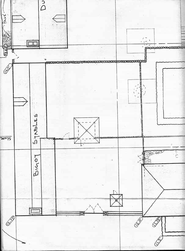
BASSE-COUR -
LOT F
[Lot F Basse-cour - Archaeology: No evidence]
Location: North of the Lot F French stables.
In Operation: 1739 - post 1758 French occupation.
Comment/Alternatives:
In 1739, the Lot F stable complex was was constructed in the Lot F basse-cour, or "lower yard." In 1742, a perimeter palisade [i.e. perhaps heavier than piquet] fence was constructed around both the Lot F basse cour and the Lot H garden.
Recommendation: Reconstruct the Lot F basse-cour in keeping with the Lot H Garden decision.
BASSE-COUR -
LOT H
[Lot H Basse-cour - Archaeology: No evidence]
Location: Immediately west of the Lot G residence and storehouse property.
In Operation: c. 1725 - post 1758 French occupation.
Comment/Alternatives:
In 1750, the Lot H 2L12V cistern was constructed in the Lot H basse-cour, or "lower yard." No doubt this Lot H basse-cour existed earlier than this date, and in fact, was positioned in the fenced off area shown in 1739 to the east of the Lot H 3rd Rodrigue house. It was here, in this Lot H basse-cour, where the Lot H 2l12V latrine for the L-shaped Lot H 2nd Rodrigue house (c. 1725-1737) existed prior to the 1736 agreement between Lot G/H for the construction of a new, commonly-shared Lot G 2L4E and Lot H 2L4E latrine complex.
Recommendation: Reconstruct the Lot H basse-cour in keeping with the Lot H Garden decision.
--------------------------
BUILDING - LOT
F
[Lot F Building - Archaeology: 2L15Q ~ Lot F Latrine
- Archaeology: No latrine pits were found]
Location: North of the Lot F stables, near its north-west corner .
In Operation: c. 1731/1734 - c. before 1739.
Comment/Alternatives:
Although the historical record vaguely suggests that latrines existed on Lot F, archaeological investigations did not uncover any latrine pits in the area of this building. At any rate, in 1739 the initial Lot F stable construction was begun in the south-west portion of Lot F, and the earlier building seemingly disappeared.
Recommendation: Not to be reconstructed.
--------------------------
CISTERN
- LOT H
[Lot H Latrine/Cistern - Archaeology: 2L12V]
Location:
In the Lot H basse-cour of the courtyard, west of the Lot G residence and 34.0 feet south-west of the Lot G 2L8A corner well. The Lot H 2L12V cistern was served by a 3-way drainage system.
In Operation: 1750 - post 1758 French occupation.
Comment/Alternatives:
In 1750, this Lot H 2L12V cistern (c. 4 feet x c. 8 feet x c. 5 feet 6 inches deep) was constructed in the Lot H basse-cour. It was possibly positioned on the site of a pre-existing, pre-dug, de-commissioned Lot H 2L12V latrine.
Recommendation: Not to be reconstructed.
--------------------------
DOVE-COTE
- LOT F
[Lot F Dovecote - Archaeology: No evidence]
Location: In the Lot F basse-cour, to the north of the Lot F stables.
In Operation: 1741 - post 1758 French occupation.
Comment/Alternatives:
The Lot F dovecote was certainly constructed in 1741, and may even appear on several subsequent French plans. It certainly appears on a sketch in the post-1758 English journal of Gibson Clough.
Recommendation: Its existing reconstruction and its location can be justified.
--------------------------
FENCE
- PERIMETER BOUNDARY -
LOTS E/F, E/H, E/I, F/G, F/H, G/H, and H/I
[No evidence except for the Lot H/I Fence -
Archaeology: Lot H Prévost portion of 2L28-29-30Q22/Archaeology:
2L28-29-30Q22. Archaeological evidence
for the Lot E/I fence [Archaeology: 2L30N,O,P,Q]
is questionable]
Location: See plan 1739-5 for perimeter boundary fences E/F, E/H, E/I, F/G, F/H, G/H, and H/I.
In Operation: Various dates to various dates [For specific dates see: Dunn, 1969 - Block 2, Lot G and Dunn 1971 - Block 2.]
Comment/Alternatives:
If the wall serving as the common wall for the Lot H (Prévost Addition) and Lot I buildings had been truly commonly owned, then the Lot H/I boundary fence ought to have been centered upon that wall if either property owner had insisted upon adherence to the Custom of Paris. Harper found this not to have been the case, at least for the portion that he had located (the Lot H Prévost Addition's west wall was an extension of the earlier Lot H/Lot I common wall.)
In c. 1734-1736, Lot G captured Lot F and the former Lot F/G perimeter boundary fence became an interior Lot F/G fence.
In 1741, Lot G captured Lot H and the former perimeter boundary F/H and G/H fences now became interior Lot F/H and Lot G/H fences.
Recommendation:
In 1739, the boundary fences assuredly took the configuration as illustrated on plan 1739-5. In 1744, the perimeter boundary fences for Lots E/F, E/H, E/I, and H/I were, no doubt, still in the same locations, and should be reconstructed at these locations. As for the former perimeter boundary fences, now interior fences F/G, F/H and G/H, they should be reconstructed in keeping with the Lot H Garden decision.
It is also recommended that Archaeology should re-examine its record with respect to the reconstructed perimeter boundary fences E/F, E/H, E/I, and H/I since, for example, the reconstructed H/I boundary fence does not reflect plan 1739-5. Naturally, if, for example, the Lot H/I and the Lot E/H west fences were extended further southward as shown on the plan, not only would it eliminate the reconstructed northern jog (which Archaeology needs to justify, if it can - for example, whether "as founds" suggests this second jog, or whether it is there for the protection of assets to the south of it (i.e. "Dugas Property - Design Team recommends that the interior of this property be left undisturbed ...." [Click here and go to B 127 166 - 168, February 18, 1980 - See also B 127 169, April 28, 1980]) - but also it would transfer several identified Lot E "as found" archaeological assets, like the Lot E 2L14W well, to Lot H ownership.
The archaeologist David Christianson provides a differing interpretation from Cox of the type of piquet fence that may have existed along the Lot H/I property line [Click here and go to B 255, June 10, 1994.] If, indeed, it were "a wattle-type fence, with horizontal wattles/brush woven between the in-ground piquets ...", then, clearly, it ought to replace the existing reconstructed fence. This possibility, archaeology should confirm, if possible, one way or another, as the written/visual historical record is inconclusive on the question.
The archaeologist R. Bruce Council, who was re-examining Cox's evidence, has looked at a portion (i.e. not the complete length) of the E/F boundary line [Click here and go to B 126, 89-90, November 12, 1975] and he found 38 feet of a supposed wall, i.e. "the stone [Lot E/F] boundary wall may have acted as a retaining wall .... [this was] a low stone wall acting primarily as a boundary line, and secondarily as a retaining wall ..." Archaeology should re-examine this finding in light of the existing reconstructed piquet boundary fence at this location. As Council further maintained: "Archaeologically, this area unfortunately has not been examined thoroughly, and thus we cannot make a firm case for the retaining wall."
Archaeology should also revisit the interpretation of the Lot E/I boundary fence [Archaeology: 2L30N,O,P,Q.] At Louisbourg, within the town, the general boundary or garden fence was of piquet construction. A fence leaving remnants of boards would have been highly unusual, though not unknown.
--
FENCE
- PERIMETER BOUNDARY - RUE ST. LOUIS - LOT F
[Lot F Fence - Archaeology: B-1D-1 ~ Archaeology: 2L7A-E]
Location: Extending south from the south-east corner of the Lot G south storehouse to the Lot F stables.
In Operation: 1741 - post 1758 French occupation.
Comment/Alternatives:
On plan 1739-5, this feature is shown as a piquet fence. However, perhaps in 1741, a masonry fence or wall replaced it when the Lot F stables were further extended eastward to Rue St. Louis from their original 1739 constructed position in the west portion of Lot F.
Recommendation:
Its reconstruction in masonry prior to 1744-1745 cannot be confidently justified. Leave as built (since both Archaeology and two post-1749 historical records support a masonry construction), but it is also recommended that, despite the evidential limitations which Cox has identified, Archaeology should re-examine the "as found" 2L7A-E record and determine whether it can/cannot be linked to the same construction date as the eastern portion of the Lot F stables.
--
FENCE
- INTERIOR - LOTS F/G,F/H,G/H
[Lot F/G,F/H,G/H Fence - Archaeology: No evidence]
Location: See recommendation below.
In Operation: Lot F/G: c. 1734-1736; Lot F/H, Lot G/H: 1741.
Comment/Alternatives:
In c. 1734-1736, Lot G captured Lot F, and the former Lot F/G perimeter boundary fence then became an interior Lot F/G fence. In 1741, Lot G captured Lot H, and the former perimeter boundary fences F/H and G/H then became the interior Lot F/H and Lot G/H fences.
Recommendation: These interior fences should be reconstructed in keeping with the Lot H Garden decision.
--------------------------
GARDEN
- LOTS F/G/H
[Lot F/G/H Garden - Archaeology: No evidence]
Location: To the north of the Lot F basse-cour of the Lot F stables.
In Operation: 1742 - 1749 (i.e. the 1744 garden.)
Comment/Alternatives:
The garden in question took its 1744 form just two years earlier, in 1742, and its design was undoubtedly altered in 1749 with the yard construction of a central Lot H 2L13V well, and its apparent ornate superstructure.
In 1742, a perimeter palisade [i.e. perhaps heavier than piquet] fence was constructed around the Lot H garden. This assumption that the enclosed 1742 garden was the existing Lot H 1739 garden and that this garden no doubt was still in use in 1744 is a most logical conclusion. On the 1739 plan, the garden would have been positioned in the fenced-off area to the south of the Lot H 3rd Rodrigue house which was demolished in 1742 after the Lot G capture of Lot H in 1741. Since, in 1742, the future Lot H jail and administrative complex was still planned for construction along the lot's Quay front, perhaps at least some, if not all, of the garden palisades of 1742 were destined to re-close the perimeter opening where the south wall of the Lot H 3rd Rodrigue house existed prior to the building's removal.
An east-west archaeological section revealed a fill material that tapered from 2.0 feet thick in the west portion (immediately south of the Lot H 2L12H latrine to nothing in the east (near the Lot H 2L12V cistern). This build-up might suggest the earlier existence of a garden more west than east of centre, at least through this section.
From time to time, Yvon LeBlanc, Louisbourg's first resident reconstruction architect now retired, had examined the yard, and, in fact, would produce a 1744 garden plan that removed the 1754 Lot H Prévost Addition from the picture. In addition, Linda Fardin, a professional historic-landscape architect, produced two garden plans in 1988 which should be consulted [Click here and go to B 330 May 04, 1988.] In her own words, however, she was hampered by the fact that she did not have access to the complete Louisbourg record.
Recommendation:
Reconstruct the Lot H garden.
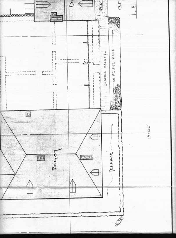
Numerous plans illustrate alternate, plausible garden configurations and interior designs, but for the general outline of the reconstructed garden, this should be based on a combination of only two plans: Plan 1739-5 [Click here], as well as plan 1744-5 [see below] which, no doubt exhibits a generic rather than actual 1744 Lot H internal garden design:
[Please click on the image to enlarge it]
Plan 1744-5
(© France: Archives du Génie (Paris, France), 14-tablette-5,
for the exclusive use by the Fortress of Louisbourg for research purposes only)In turn, this general design will determine the configuration of the Lot F basse-cour, the Lot H basse-cour, the interior fences F/G, F/H and G/H, and the existence of the Lot H 2L14V well or latrine.
The interior design of the garden must reflect the input of a professional historic-landscape architect familiar with not only 18th century French garden design but also the Louisbourg garden experience of 1713-1758 as reflected by its period documents and plans, as well as by the numerous interpretative historical and archaeological reports issued by the Fortress of Louisbourg (for example, see The gardens of Louisbourg; Life in the Barracks, and Ken Donovan, The myth of French Agricultural Inactivity: Gardens and Gardening in Ile Royale (Fortress of Louisbourg Unpublished Report H F 77), March 30, 1990; and Ken Donovan's forthcoming report on the historic gardens of Louisbourg.)
Archaeology has also identified the following concern:
"The archaeological removal of materials from the Bigot garden has been done, but research and report work has never been completed. Part of this project would require hiring an archaeologist who could interpret the "as found" data and incorporate it into the context of the operation ..." [For more details, click here and go to B 333, August 15, 1990]
--------------------------
HOUSE
- 3RD RODRIGUE HOUSE - LOT H
[Lot
H Rodrigue 3rd House -
Archaeology: c. 2L9F,G,M,N; 2L12A,B]
Location: Within the Lot H Prévost Addition's footprint, near the Lot H/I boundary fence.
In Operation: c. 1738 - 1741 (Demolished in 1742.)
Comment/Alternatives:
Archaeology has established this Lot H 3rd Rodrigue building too far south, at the doubtful location of Archaeology: 2L30Q, 2L31Q, along the Lot H/I boundary line. More likely, the building stood further north, perhaps even as far north as within the footprint of the future 22.0 x 10.5 foot south-west extension of the Lot H Prévost Addition.
Fenced off to the south of the building stood its Lot H garden; to the east, its Lot H basse-cour; and to the west, in the attached building, a new Lot H latrine. In September, 1738, Lot H became a sub-divided property, with separate west and east ownership: in the west - the 3rd Rodrigue house (perhaps just having been built), its latrine, and 1/2 of the garden; in the east - the Lot H basse-cour, the existing Lot H 2L4E latrine in the passageway, and the other 1/2 of the garden.
The 3rd Rodrigue house was a charpente house built in the interior of Lot H along the line of the south masonry wall of a proposed 1737/1738 large Lot H 4th Rodrigue house designed to occupy the entire quayside breadth of the now divided Lot H East/West property. If the Lot H masonry building had been constructed, no doubt the 3rd Rodrigue house, in one form or another, together with its Lot H 2L10F, 2L10G latrine to the west of it, would have continued to exist where it stood, attached and for the use of the Lot H west owner.
Recommendation: Not to be reconstructed.
--------------------------
LATRINE
- LOT G
[Lot G Latrine - Archaeology: ?]
Location: Presumed to be somewhere on Lot G, to the south of the 1721 Lot G residence, between the Lot G house and Lot G storehouse.
In Operation: 1721 - 1736.
Comment/Alternatives:
During its early period, the Lot G residence reached 26 pieds into the yard and occupied the full quayside width of the property. In 1736, the residence - together with its newly acquired 4 pieds wide, 46 pieds deep passageway along its western wall - was extended to 46 pieds of depth, and fully occupied the new width of the property. Logically then, the Lot G latrine (1721-1736) for the residence existed within the lost 20 pieds of courtyard since Archaeology did not locate a latrine pit anywhere in the now existing Lot G yard.
Recommendation: Not to be reconstructed.
--
LATRINE -
LOT G
[Lot G/H Latrines - Archaeology: B-1B-1-5
~ Lot G/H Latrines - Archaeology: 2L4E]
Location:
This newly constructed Lot G 2L4E latrine existed near, and within, the south extremity of the newly acquired Lot H 4 pieds wide, 46 pieds deep passageway (living area above), approximately 46 pieds south of the Lot G property line where this latrine and the new Lot H 2L4E latrine backed upon a quite large, though relatively shallow, shared pit, c. 4 feet 3 inches x c. 9 feet x c. 2 feet 3 inches deep. When water entered the pit from the courtyard, this action flushed the contents through a drain that ran down the passageway, out across the Quay and into the harbour.
In Operation: 1736 - 1754.
Comment/Alternatives:
LeNormant, the Commissaire-Ordonnateur, claimed in 1736 that he required latrines since he didn't have any, and so he had this one constructed in the passageway, and agreed to share the common pit with a new Lot H 2L4E latrine. Logically, this requirement arose when the earlier Lot G latrine (1721-1736) was about to be lost during the south expansion of the Lot G residence further into the Lot G yard. Until 1741, the replacement Lot G 2L4E latrine existed as a shared Lot G/H resource which legal co-existence ceased when that year Lot G captured the rest of Lot H. Afterwards, until 1754, it operated as an exclusive Lot G asset.
It is highly doubtful that the official home of the French Commissaire-Ordonnateur and English Governor (1745-1749) would have tolerated any latrine so distant as the Lot H 2L12H latrine when one could have been built much nearer, almost anywhere, on the 1741 captured Lot H property. The fact that Lot H would have brought to Lot G an even less distant latrine pit at Lot H 2L10F, 2L10G, which was already ready-dug and fully functioning, argues even more against the construction of the Lot H 2L12H latrine at any time before the first siege.
More logically, the 1736 Lot G 2L4E latrine existed until 1754 when the Lot H Prévost Addition and its replacement Lot H 2L12H latrine was constructed. For example, if the Lot G 2L4E latrine was sufficiently large enough to have served two households when originally built, after 1741, it became even more so when it served but one. Also, even if its flush drain had been closed in 1742, it still could have served as a traditional pit latrine, despite its relative shallowness. At regular intervals, its "night soil" could have been collected, and disposed of as was customary with other pit latrines at Louisbourg. For this property owner, cost would not have been a consideration.
The archaeological synopsis is problematic as to whether its investigations actually determined the approximate date for when the north and south ends of the passageway were closed off, when the original west wall was removed, and when the extension of the ground floor was carried over to the Lot G/H common wall, thus effectively removing the latrine complex from possible operation. Indeed, all these changes may have taken place in 1754 (Lot H Prévost Addition) rather than in c. 1742. On the other hand, Archaeology has more strongly determined that the sewer drain was effectively terminated in 1742 at the spot of the construction of the quayside retaining wall.
Recommendation:
Archaeology should revisit its conclusion that this latrine completely ceased operation in c. 1742. Other than its evidence that the sewer was seemingly plugged and rendered in-operable in c. 1742 - which, in any case, was not necessarily a death-kneel modification - its case depends entirely on an unproven assumption that Lot G completed its ground-floor passageway renovations sometime before the first siege.
--
LATRINE
- LOT H
[Lot H Latrine/Cistern - Archaeology: 2L12V]
Location: In the Lot H basse-cour of the courtyard, west of the Lot G residence and 34.0 feet south-west of the Lot G corner 2L8A well.
In Operation: 1725 - 1736.
Comment/Alternatives:
A latrine was positioned, no doubt, somewhere in the Lot H basse-cour which, in 1739, existed within the fenced off area to the east of the Lot H 3rd Rodrigue house. This latrine (1725-1736) served the L-shaped Lot H Rodrigue 2nd house (c. 1725-1737) prior to the 1736 agreement between Lots G/H for the construction of a new, commonly-shared Lot G and Lot H 2L4E latrine complex.
In 1736, the existing c. 1725 - 1736 Lot H latrine might have existed at one of two precise locations in the Lot H basse-cour:
First, perhaps at 2L12V, where before the discovery of its drainage system and determination that this was a Lot H 2L12V cistern built in 1750, Archaeology had originally considered its pit as representative of one for a typical, rectangular Louisbourg latrine. If indeed there had been an earlier latrine at this location, then it would have been de-commissioned in 1736 as it was no longer required and later re-worked as the Lot H 2L12V cistern.
Second, it may even have been located at 2L4E where this new Lot H 2L4E shared latrine complex was actually positioned on/near the spot of an existing Lot H latrine (c. 1725-1736).
Recommendation: Not to be reconstructed, but perhaps a depression might have been obvious in 1744 if it can ever be clearly determined that on this location a pre-siege latrine once existed.
--
LATRINE -
LOT H
[Lot
G/H Latrines - Archaeology: B-1B-1-5
~ Lot G/H Latrines - Archaeology: 2L4E]
Location:
This newly constructed Lot H latrine existed near, and within, the south extremity of the Lot H 4 pieds wide, 46 pieds deep passageway (living area above), approximately 46 pieds south of the Lot G property line which passageway Lot G had newly acquired and where this latrine and the new Lot G 2L4E latrine backed upon a common, relatively shallow pit, c. 4 feet 3 inches x c. 9 feet x c. 2 feet 3 inches deep. When water entered the pit from the courtyard, this action flushed the contents through a drain that ran down the passageway, out across the Quay and into the harbour.
In Operation: 1736 - 1741.
Comment/Alternatives:
The question why Lot H would require a new latrine in 1736 should draw some interesting speculation. Certainly, if there was already existing either the large 1754 Lot H 2L12H latrine to the south of the ell of the present L-shaped Lot H 2nd Rodrigue house (c. 1725-1737), or the Lot H 2L10F, 2L10G latrine to the west of the future 3rd Rodrigue house (1738-1742), another one far to the east would have been unnecessary. On the other hand, assuming that an old Lot H 2L12V latrine had been functioning c. 1725 - 1736 (or even since c.1714 - the first house), it was perhaps long due for a complete re-furbishing. Furthermore, the possibility that this new Lot H 2L4E shared latrine complex was actually to be positioned on/near an existing Lot H latrine (c.1714-c.1724 and/or c. 1725-1736) also exists.
At any rate, Lot G's overt desire to obtain the 4 pieds wide Lot H passageway - to house a new Lot G 2L4E latrine to replace its existing Lot G latrine (1721-1736) about to be lost to Lot G's residential expansion into the yard - was probably sufficient leverage for Lot H to obtain a shared 2L4E latrine replacement of its own. Ironically, this latrine then served the Lot H 2nd Rodrigue house (c. 1725-1737) for but one year until the house was destroyed by fire in 1737.
On September 13, 1738, Lot H was sub-divided into two family lots, one to the east (which included the Lot H 2L4E latrine) and one to the west. By September 16, 1738, Lot H 3rd Rodrigue house had been constructed in the interior of the western portion of the property with its own Lot H 2L10F, 2L10G latrine attached to the west wall of the building. However, just as plans for a duplex fronting Lot H reached fruition in the fall of 1738, the Lot G Commissaire-Ordonnateur ordered it stopped, and shortly afterwards, in 1741, acquired the entire Lot H property by sale.
Recommendation: See the recommendations for the Lot G 2L4E latrine.
--
LATRINE -
LOT H
[Lot H Latrine - Archaeology: B-1A-4 ~
Archaeology: 2L10F, 2L10G]
Location: Against the Lot H/I boundary line, in the small outbuilding built against the west wall of the Lot H 3rd Rodrigue house, c. 20 feet south of the Lot I house.
In Operation: c. 1738 - 1741.
Comment/Alternatives:
Archaeology has identified this unlined pit (12 feet x 15 feet x 5 feet deep) as existing on Lot I. Plan 1739-1 clearly illustrates that the jog in the Lot H/I boundary fence at this location positions this feature within the west portion of the divided Lot H East/West property, against the west wall of the Lot H 3rd Rodrigue house. Given that the Lot H 2L4E latrine had been transferred in 1738 to Lot H East ownership, that the Lot H 3rd Rodrigue house was a planned structure to remain where built following construction of the proposed 4th Rodrigue house (its basement excavations were halted in the fall of 1738), and that the Lot H 2L12H latrine to the south of the 2L10F, 2L10G latrine did not exist until 1754, this latrine location makes perfect sense.
Of speculative interest is how the Lot H/I fence to the north and to the south of the latrine were configured. To the north, it met the 2L10F, 2L10G feature at its mid-way point; to the south, at its south-west corner. This configuration is highly suggestive of a common Lot H/I latrine.
Recommendation:
Archaeology should revisit the Harris conclusion that "All that is known with any certitude is that the latrine was dug after the construction of the Prevost extension which occurred in 1754" to determine whether this statement is true, and if not, whether the latrine could have been operational as early as 1738 either as a Lot H, or shared Lot H/I asset.
--
LATRINE
- LOT H
[Lot H Latrine - Archaeology: 2L12H]
Location: Located 22.7 feet south of the Lot H Prévost extension, against the Lot H/I boundary fence.
In Operation: 1754 - post 1758 French occupation.
Comment/Alternatives:
This was a large latrine (4.5 feet x 7.1 feet x ? deep), relatively adjacent to the Commisaire-Ordonnateur's so called Prévost Addition. Without a doubt, this latrine neither serviced the 1738-1742 Lot H Rodrigue 3rd house - it had its own Lot H 2L10F, 2L10G latrine - nor did it exist prior to the construction of the 1736 Lot H 2L4E latrine.
Recommendation: Not to be reconstructed.
--------------------------
STABLE -
ENGLISH - LOT E/H
[Lot E/H English Stables - Archaeology: 2L31O,2L32O,P]
Location: Partly in the Lot H yard, between the Lot E 2L14W well and the Lot H 2L14V well or latrine to the south and the Lot H 2L13V well to the north.
In Operation: 1746 - post 1758 French occupation.
Comment/Alternatives: N/A.
Recommendation: Not to be reconstructed.
--------------------------
WALKWAY
- FLINT - LOT G
[Lot G Flint Walkway - Archaeology: ?]
Location: Just a few feet west, beyond the Lot G pavé, leading upon the Lot H Cistern.
In Operation: 1750 - post 1758 French occupation.
Comment/Alternatives: The walkway appears to be related to the construction of the Lot H cistern.
Recommendation: Not to be reconstructed.
--
WALKWAY - PAVÉ - LOT G
[Lot G Pavé - Archaeology B-1C-2 ~ Archaeology: 2L8B,C,E,F,H,I; 2L12G,N,T,U; 2L13G,N,U; 2L14G,N,U]
Location: Flanked the west side of the Lot G storehouse and the south wall of the Lot G residence.
In Operation: c. 1721 - post 1758 French occupation.
Comment/Alternatives:
No doubt related to the original and enlarged construction of the Lot G storehouse and residence. It ranged in width from 7 feet to 9 feet.
Recommendation: Its existing reconstruction and its location can be justified.
--------------------------
WELL
- LOT E
[Lot
E Well - Archaeology: 2L14W]
Location: c. 58 feet west of the south end of the Lot G south storehouse.
In Operation: 1722/1726 - ?.
Comment/Alternatives: This very small (perhaps seasonal) well (2.5 feet wide x 2.0 feet deep) is actually on Lot H.
Recommendation:
It is recommended that Archaeology should re-examine its record with respect to the Lot H/I boundary fence since it's configuration does not reflect plan 1739-5. If the line of the Lot H/I fence were extended further south at the meeting point of the Lot E/I boundary, this action would bring the presumed well of Lot E within Lot H and hence, in 1741 and afterwards, under Lot G control. Likewise, other assets would be equally affected.
The written measurement that accompanied Plan 1734-5 (48 pieds) and the scaled distance on Plan 1739-5 (c. 54 pieds) for the depth of Lot E to where its Lot E/F boundary line met Lot H clearly illustrates that in 1744 Lot H and its south jog stood further south than reconstructed. Obviously, the reconstructed north jog is totally incorrect, as it most certainly does not match the spirit of either 1734-5 or 1739-5. While the Lot E/I boundary fence may be in the approximate correct location (98 pieds from Rue Royalle), the Lot E/H west boundary line assuredly is not. Clearly, once the accurate line of the Lot H/I perimeter fence has been determined over its entire length, from where it intersects - at the approved angle - the historically correct Lot E/I boundary, simply extend the Lot E/H west boundary fence at the same angle to that point where it will stand 48 pieds south of Rue Royalle. From here, the fence would then jog east, to bear directly upon the fore-mentioned boundary intersection of Lots E, F and H.
--
WELL
- LOT F
[Lot F Well - Archaeology: B-1D-1 ~ Archaeology: 2L7B,C]
Location: 12 feet south of the Lot G south storehouse, next to the Lot F Rue St. Louis perimeter boundary fence .
In Operation: 1739 to c. 1745 (English Occupation) - 1749 (French Occupation)
Comment/Alternatives:
In 1739, Commissaire-Ordonnateur Bigot claimed that he needed to construct this Lot F well (3.2 feet of diameter x 10.3 feet deep) because there was no other one on the Lot F/G property. Since the Lot G 2L8A well must have existed since c. 1721-1725 with the construction of the Lot G residence, this assertion was was no doubt hyperbole, intended to gain a new well for the captured Lot F property and its new Lot F stable.
Recommendation: Its existing reconstruction and its location can be justified.
--
WELL
- LOT G
[Lot G Well - Archaeology: 2L8A]
Location: In the Lot G courtyard, partially on the Lot G pavé, at the angle of the ell of the Lot G residence.
In Operation: c. 1721 - 1725 to 1749, if not to post 1758 French occupation.
Comment/Alternatives:
In 1739, Commissaire-Ordonnateur Bigot claimed he needed to construct a new well (3.0 feet of diameter x 13.53 feet deep) because there was no other one on the Lot F/G property. Actually, his lobby was for the Lot F 2L7B,C well relatively near the new Lot F stables, and in his hyperbole, he neglected to mention the existence of this Lot G 2L8A well which must have been functioning since c. 1721-1725 with the construction of the Lot G residence of the Commissaire-Ordonnateur.
Recommendation: Its existing reconstruction and its location can be justified.
--
WELL -
LOT H
[Lot H Well - Archaeology: B-1C-1 ~ Archaeology: 2L13V]
Location: c. 36 feet west of the Lot G storehouse, in the centre of the yard, but not in a garden.
In Operation: 1749 - post 1758 French occupation.
Comment/Alternatives:
While Archaeology found a brick lined well (3.10 feet of diameter x 11.6 feet deep) - with evidence of an apparent ornate superstructure - the written historical record clearly indicated that, in 1749, it was not brick lined. Perhaps the brick lining was added at a later date to hold the original outer rubble stone lining in place.
Recommendation: Not to be reconstructed.
--
WELL
- LOT H
[Lot H Well - Archaeology: 2L14V]
Location: 34.8 feet west of the south end of the Lot G south storehouse.
In Operation: c. 1739 - post 1758 French occupation.
Comment/Alternatives:
Although this feature may have appeared on some plans only after 1745, a shallow (perhaps seasonal) well (3.1 feet of diameter x 4.8 feet deep) at this location would certainly have proven useful to animals during either/or both the French and English (Lot F English stables) occupations and might therefore have existed prior to 1745 or not.
There is also the possibility that this was a latrine and not a well.
Recommendation: Reconstruct it as a well or latrine only if the Lot H Garden decision should allow for it.