Bigotyard
Website Design and Content © December 14, 2001, by
Eric Krause, Krause House Info-Research Solutions
(© 1996)
All Images © Parks Canada Except
Where Noted Otherwise
Researching the
Fortress of Louisbourg National Historic Site of Canada
Recherche sur la Forteresse-de-Louisbourg Lieu historique national du Canada
Fortress of Louisbourg, Block Two,
Lots F/G/H Properties:
Landscape Arrangements as of 1744
REPORTS
BACK
Chronological Index ~ Annotated Extracts from Historical and Archaeological
Reports of the Fortress of Louisbourg, 1959 - Present
Note: [...] represent Krause Annotations
Donald Harris, A Summary of the Archaeology of the Town Site of Louisbourg, 1959-79, Unpublished Report AE 55 (Fortress of Louisbourg, 1982) - Extracts
[165]
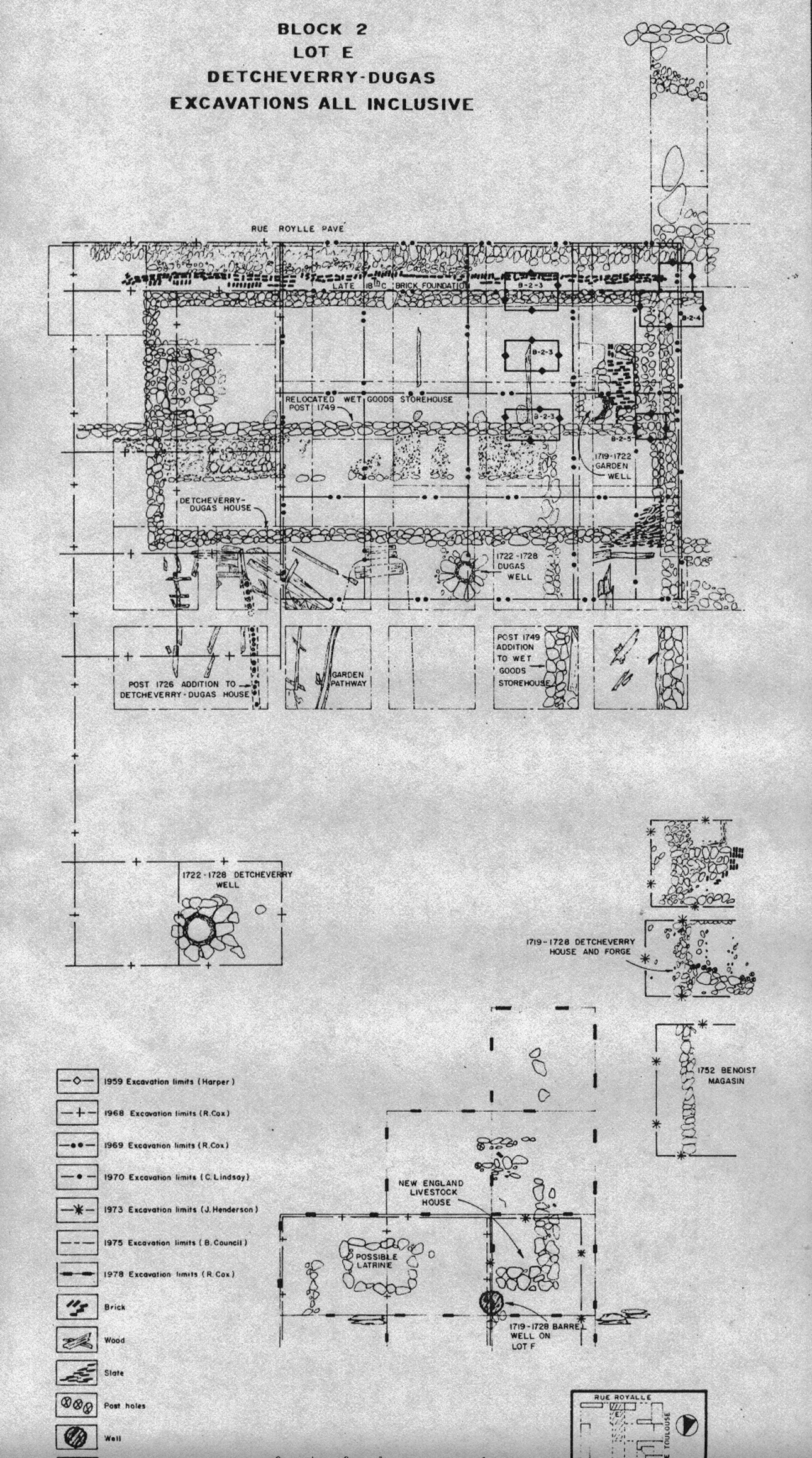
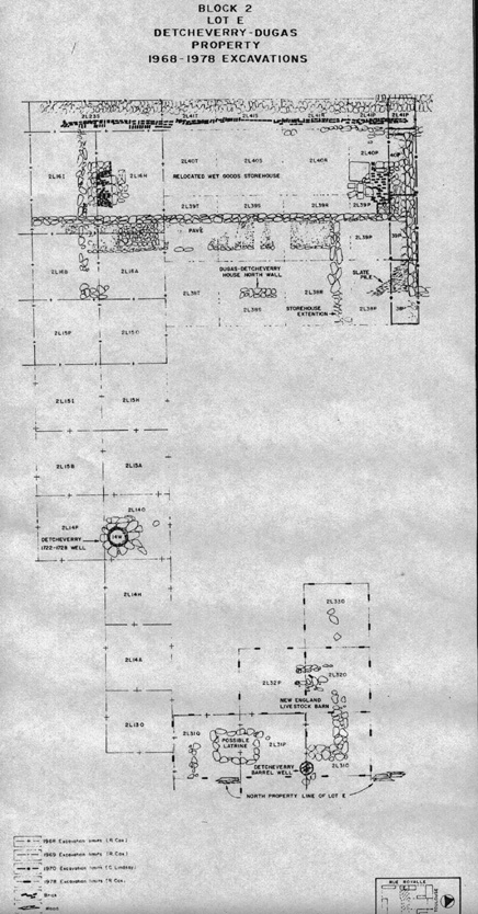
Block 2 - Lot E - Detcheverry-Dugas Property ...
Historical Synopsis ...
1722-23: Detcheverry entered into an agreement with Joseph Dugas, a carpenter, to build a 45 pieds by 24 pieds duplex along the rue Royalle side of the property ... [166] Access [for Dugas] was also available to the yard along the Lot F side of the property.
1724-36: ...
By 1731 the town plans show a building at the southwest corner of Lot F which was separated from Lot E by a gap of approximately 6 pieds ...
1736-45 ...
In 1739 stables were erected for the Commissaire-Ordonnateur on Lot F and a 6 pieds wide alleyway was officially conceded to Lot E. This addition made the dimensions of the property fronting rue Royalle 51 pieds instead of 45 pieds ...
[168]
Archaeologist: Richard E. Cox (1968)
The 1968 excavations on the Detcheverry-Dugas property consisted mainly of the investigation on the Detcheverry-Dugas property consisted mainly of the investigation of a stone-lined well [Lot E Well - Archaeology: 2L14W ] midway along the eastern property line. At the time of its excavation it was thought to have been on the property of the Commissaire-Ordonnateur, but subsequent study of lot boundaries places the well just within the boundaries of Lot E. This well probably dated to the Detcheverry occupation of the eastern end of the rue Royalle house in the 1720s ...
[For the moment, this well is considered to be a Lot E rather than a Lot H asset, although Plan 1739-5 suggests that it actually stood on Lot H.]
Well 2L14W ....
[169]
Archaeological Synopsis ...
1722-23: ...
In the yard a stone-lined well was dug just to the north of the house (2E29) ... The fill that resulted from its digging was probably deposited in the yard adjacent to the well (2E24) ... The well itself was immediately adjacent to the house and may have been in that area given to Dugas in the original Detcheverry-Dugas agreement as a place to store his firewood. On the other hand, it may have been dug after Dugas had acquired an additional 12 pieds from Detcheverry in 1726. Council [Archaeologist 1975] has conjectured that this well probably serviced both residences, but the presence of another stone-lined well (2E61) midway along the eastern property line would argue against that supposition. This other well [Lot E Well - Archaeology: 2L14W] had been excavated by Cox in 1968 and backfilled but Council was not aware that it belonged to Lot E at the time he was considering his data ...
[For the moment, this well 2L14W is considered to be a Lot E rather than a Lot H asset, although Plan 1739-5 suggests that it actually stood on Lot H.]
[172]
1734-49: ...
[172[
... In the rear of the property the 1978 excavations exposed the stratigraphic sequence of that part of the site related to the barrel-lined well [Lot E Well - Archaeology ~ 2L31P27-29], the forge wastes and the early soil development mentioned above ... Although these layers have not been excavated and, [173] hence, have not been related to known, datable features, the following interpretation of the events that gave rise to them is tentatively offered ... Above the thin humic layer, a layer of yellow sandy gravel was deposited (2E74). This layer may represent a levelling activity on the part of the New England occupants prior to the construction of the "new house for livestock" (2E64) represented by a rectangular stone foundation. For the purposes of this report this building will be referred to as the New England stables [Lot E/H English Stables - Archaeology: 2L31O,2L32O,P] ...The stone foundation was located in approximately the same position as one shown on the 1746 plan of Louisbourg [1746-8] where it was stated to be a new construction erected to house livestock. This building does not appear on later French plans of the 1750s until 1758 when a building is shown in approximately the same position by Pierre Lartigue, who made a plan of the town after the 1758 siege. Whether this is the same building is uncertain. Other activities which might have taken place during this period were the construction of a boundary fence (2E26) [Lot E/F Fence - Archaeology ?] between Lots E and F and the placing of a gate across the [174] mouth of the alleyway between Lots E and F (2E42) ...
[Note: The exact quote is: " 15. New house for Stock at the Governors." and on site plans the archaeological location is given as c. 2L31O,2L32O,P. According to Harris, this placed the English stables on Lot E immediately south of what archaeology has assumed assumed to be the Lot E/I property line, and but a short distance from the assumed Lot H/I property line where the lot H/I property fence post remnants were excavated and identified as 2L28-29-30Q22. Archaeology exposed only the ell of the north-west corner of the stables, suggesting that the main body lay south and east of this corner, with its south wall sited perhaps just north of the Lot E well 2L14W [Note: For the moment, this well is considered to be a Lot E rather than a Lot H asset, although Plan 1739-5 suggests that it actually stood on Lot H.]
[However, Dunn places this feature on Lot F - See Dunn '69 CO and not on Lot E. For the purposes of this study, I have placed the stables as being Lot E/H English Stables - Archaeology: 2L31O,2L32O,P since some historical plans and this archaeological interpretation both suggest that this feature extended east and west of the property line, but upon Lot H and not upon Lot F]
[On November 12, 1975, the archaeologist R. Bruce Council, who was re-examining Cox's evidence, reported upon a portion (i.e. not the complete length) of the E/F boundary line and he found 38 feet of a supposed wall, i.e. "the stone [Lot E/F] boundary wall may have acted as a retaining wall .... [this was] a low stone wall acting primarily as a boundary line, and secondarily as a retaining wall ... Archaeologically, this area unfortunately has not been examined thoroughly, and thus we cannot make a firm case for the retaining wall."]
-------------------------------------------------
[195]
Block 2 - Lot F - Genier-Commissaire-Ordonnateur-Rodrogue Property ... [incorporpated into Block 2 - Lot G after 1738-39]
Historical Synopsis ...
... The lot apparently remained undeveloped until 1731 when a small building [Lot F Building - Archaeology: 2L15Q ~ No latrine pits were found] is shown on a plan of that year ...
1738-39: After the lot became part of the official property, the Commissaire-Ordonnateur at that time, François Bigot, had a stable for small livestock erected at the southwest corner of the lot. By this time the previously mentioned building no longer seemed to have been in existence ...
-------------------------------------------------
[196]
Block 2 - Lot G - Genier-Commissaire-Ordonnateur-Rodrigue Property ...
Historical Synopsis ...
1720-36: Shortly after DeMesy bought the lot from Genier, he began the construction of a two storey, masonry storehouse along the eastern border of the property ... After ... he began work [197] on the construction of a house which was to front on the Rue du Quay ...
In the état of 1734 the measurement of the property were given as 36 pieds by 150 pieds and the house measured 36 pieds along rue du Quay and 26 pieds into the property .. The widow Rodrigue complained that this action would deny her access to the interior of [198] her property. The problem was finally resolved by leaving a 4 pieds wide passageway on the ground floor between the two buildings ... in conjunction with the construction of the passageway, the Commissaire-Ordonnateur was to construct [new] latrines [Lot G/H Latrines - Archaeology: B-1B-1-5 ~ Lot G/H Latrines - Archaeology: 2L4E] for the widow which backed on and shared a common pit with those [Lot G/H Latrines - Archaeology: B-1B-1-5 ~ Lot G/H Latrines - Archaeology: 2L4E] of the Commissaire-Ordonnateur ... During the same year the Commissaire-Ordonnateur's property was extended to the south to incorporate Lot F, which at that time measured 69 pieds along rue Royalle and 48 pieds along rue St. Louis ...
1736-45: ...
[199]
In 1738 LeNormant was replaced [by] ... Francois Bigot who arrived in 1739 ... Also in 1739, Bigot complained of not having a well on his property and as a consequence one [Lot F Well - Archaeology: 2L7B,C] was dug by the end of the year just to the south of the storehouse on rue St. Louis. Bigot also put into effect other changes to the property when he arrived ... constructed a stables at the southwest corner of the old Lot F to house small livestock such as sheep and poultry ... The stables erected in 1739 were extended the full width of the property to the corner of rue Royalle and rue St. Louis. A dovecote [Lot F Dovecote - Archaeology: No evidence] was added to the central area of the courtyard in 1741 ...
[Note: Since an earlier, but distant, well [Lot G Well - Archaeology: 2L8A] must have existed since c. 1721-1725 with the construction of the residence, Bigot's assertion of not having a well was no doubt hyperbole, intended to gain a new well [Lot F Well - Archaeology: 2L7B,C] for the captured Lot F property and its new stable.]
[200]
1749-58: ...
A new well [Lot H Well - Archaeology: B-1C-1 ~ Archaeology: 2L13V] was dug in the central area of the courtyard in 1749 ...
Plans for the extension to the Commissaire-Ordonnateur's house were generated almost immediately upon the return of Prevost to Louisbourg ... This resulted in the construction of an extension to the western side of the Commissaire-Ordonnateur's building which was completed in 1754. This extension, referred to as the Prevost Addition, filled the rue du Quay frontage of the old Lot H and used the east wall of the Pugnant dit Destouches house as a common wall for part of its west wall. The remainder of Lot H was converted into gardens or used for other household related purposes ...
-------------------------------------------------
[201]
Block 2 - Lot H - Genier-Commissaire-Ordonnateur-Rodrogue Property ... [incorporated into Block 2 - Lot G in 1741]
[201]
Historical Synopsis ...
Upon buying Lot G, DeMesy promptly began construction of a new [202] masonry storehouse ... DeMesy planned to erect a house for himself on this end of his lot which would have required 40 pieds frontage on rue du Quay ...
1725-37: ... By 1734 there seems to have been another small building [Lot H Well - Archaeology: B-1C-1 ~ Archaeology: 2L13V] constructed in the yard and the property which measured 48 pieds by 150 pieds was enclosed by a piquet fence [No evidence except for the Lot H/I Fence - Archaeology: Prévost portion of 2L28-29-30Q22/ Archaeology: 2L28-29-30Q22]. The rear or southern part of the property was shown in 1734 as being cultivated [Lot H Garden - Archaeology: No evidence] ... In 1736 he [LeNormant] wanted to expand the Commissaire-Ordonnaterur's house 4 pieds further to the west. An agreement .... with the widow Rodrigue ... [203] Also the widow was to retain access to the interior of her property via a 4 pieds wide passageway ... The final condition of this sale was the construction of latrines by LeNormant for the use of the Rodrigues. These [new] latrines [Lot G/H Latrines - Archaeology: B-1B-1-5 ~ Lot G/H Latrines - Archaeology: 2L4E] were to have been built at the end of the passageway, backing on those [Lot G/H Latrines - Archaeology: B-1B-1-5 ~ Lot G/H Latrines - Archaeology: 2L4E] of the Commissaire-Ordonnateur and sharing the same cesspit ... Unfortunately, shortly after all of this construction was completed a fire, which began in the Rodrigue house, swept down rue du Quay destroying all of the buildings that fronted Lots H, I, K and L ...
1737-42: After the fire destroyed the rue du Quay house, it seems that a small house [Lot H 3rd Rodrigue House - Archaeology: c. 2L9F,G,M,N; 2L12A,B] was built within the interior of the property ...
[204]
The ruling which finally came down was in favor of the Commissaire-Ordonnateur and in 1741, by royal order, the property was sold to the Crown. The sale included the lot which measured 44 pieds by 150 pieds and was surrounded by a piquet fence [No evidence except for the Lot H/I Fence - Archaeology: Prévost portion of 2L28-29-30Q22/ Archaeology: 2L28-29-30Q22], the 22 pieds square house [Lot H 3rd Rodrigue House - Archaeology: c. 2L9F,G,M,N; 2L12A,B], and the passageway with its latrines [Lot G/H Latrines - Archaeology: B-1B-1-5 ~ Lot G/H Latrines - Archaeology: 2L4E.]
Archaeological Investigation
Archaeologist: J. Russell Harper (1959)
The 1959 excavations consisted of a series of test trenches dug in a number of locations scattered around the property of the Commissaire-Ordonnateur. Five tests were made in the western, Prevost addition [Lot H Prévost Addition - Archaeology: B-1A-1-5], both inside and outside the building. The cellar ... was exposed ... as were the corner stones of the building and a latrine [Lot H Latrine - Archaeology: B-1A-4 ~ Archaeology: 2L10F, 2L10G] which had once serviced the Pugnant dit Destouches [Lot I] property [Actually it serviced the Lot H Rodrigue 3rd House [Lot H Rodrigue 3rd House - Archaeology: c. 2L9F,G,M,N; 2L12A,B] - Also, Harris neglected to describe Harper's possible Prévost portion of the Lot H/I Fence - Archaeology: Prévost portion of 2L28-29-30Q22/Archaeology: 2L28-29-30Q22] ... Five test trenches were dug in the ... [eastern Bigot residential] building [Lot G Residence - Archaeology: B-1B-1-5] as well. These exposed ... the [new] latrine [Lot G/H Latrines - Archaeology: B-1B-1-5 ~ Lot G/H Latrines - Archaeology: 2L4E] which had been built by LeNormant for the widow Rodrigue and the drain or sewer which exited from it were also excavated ... Three test trenches were dug in the courtyard [Lot G/H Courtyard - Archaeology: B-1C-1-3] in an attempt to locate courtyard features such as pavé [Lot G Pavé - Archaeology B-1C-2 ~ Archaeology: 2L12T-2L12U (Portion of Lot G Pavé - Archaeology B-1C-2 ~ Archaeology: 2L8B,C,E,F,H,I; 2L12G,N,T,U; 2L13G,N,U; 2L14G,N,U)] and the prison. One stone-lined depression thought to have been a well [Lot H Latrine/Cistern - Archaeology: 2L12V] was excavated, but this 4 ft. by 7 ft. by 6 ft. [deep] structure proved to be barren of artifacts and, as a consequence, Harper assigned no provenience designation to the feature. The entrance area to the courtyard off rue St. Louis was also sampled and a segment of the stone wall [Lot F Fence - Archaeology: B-1D-1 ~ Archaeology: 2L7A-E] that had bounded the eastern side of the property between the storehouse and the stables was uncovered. Harper also made an attempt to excavate the well [Lot F Well - Archaeology: 2L7B,C] Bigot had dug in 1739, but discontinued this operation when water was encountered at a very shallow depth. He also failed to assign a provience designation to this test ...
Prevost Addition B-1A-1-5
Restored house B-1B-1-5
Courtyard B-1C-1-3
Entrance area B-1D-1 ...
[206]
Archaeologist: Richard E. Cox (1968-70)
This series of excavations consisted of extensive investigations of the house, storehouse, Prevost addition, stables and the area in the immediate of these structures. Test trenches were dug through the courtyard and most of the wells, latrines and other features were excavated. These yard features included four wells, a large catch basin [Lot H Latrine/Cistern - Archaeology: 2L12V] and drainage system, a rectangular latrine [Lot H Archaeology: 2L12H] and the interior terrace. The catch basin was devoid of any fill, indicating that it had been previously excavated by souvenir hunters. The well [Lot F Well - Archaeology: 2L7B,C] to the south of the storehouse also gave indications of having been disturbed at an earlier date, but this was not definite. The latrine [Lot H latrine - Archaeology: 2L12H] on the western boundary of the property yielded a large quantity of artifacts thought to be representative of the second French occupation of Louisbourg ... Along the western wall of the Commissaire-Ordonnateur's house, the remains of the [new] latrine [Lot G/H Latrines - Archaeology: B-1B-1-5 ~ Lot G/H Latrines - Archaeology: 2L4E] and drain installed in 1736 were excavated. Harper had excavated the latrine in 1959, but Cox excavated the drain which had been sealed by the construction of the terrace wall along the north side of the building. During this operation Cox found the blocked doorway which had provided access to the passageway mentioned in the 1736 [207] agreement. At the south end of the lot were the scanty remains of the stables that had occupied that part of the property from 1739 until 1768 or slightly later. The courtyard to the north of this building showed signs of having been levelled at some point in its history.
...
Garden wall and rue St. Louis 2L7A-E
Courtyard
2L7C
2L8A-L
2L9G, N, T, U
2L11F, G, M, N
2L12A, C-H, K-0, R-V
2L13E-G, L-N, Q-V
2L14C-G, J-V
2L15C, d, F-J, M-Q, U
...
Well south of
storehouse
2L7B,C
Well at angle of courtyard terrace 2L8A
Latrine on west
boundary
2L12H
Well in centre of
courtyard
2L13V
Catch basin in
courtyard
2L12V
Well west of south storehouse
2L14V
[208]
Archaeologist: E. Willis Stevens (1974)
A small series of excavations were undertaken in 1974 in the courtyard of the stables. No features were uncovered, but the excavation revealed that the soil profiles in the courtyard had been truncated during earlier landscaping activities ...
Courtyard 2L70A-E, J-L
Archaeologist: R. Bruce Council (1975)
The 1975 excavations were actually a re-excavation of the Harper and Cox excavations of the eastern end of the stables ...
Archaeologist: Richard E. Cox (1978)
The 1978 archaeological season saw the completion of the excavations of the courtyard of the Commissaire-Ordonnateur's property. These investigations concentrated on all those areas of the courtyard that had not been completely excavated previously.
Courtyard 2L9G, N, T, U
2L11G, N
2L12A-D, F, H, I-M, P, Q, R, T
2L13A-D, F, H-M, 0, P, R, T
2L14A-F, H-M, O-R, T
2L15B, C, J
Archaeological Synopsis
...
]211]
...
1725-36: Once the DeMesy house was constructed and occupied (2G20) it seems to have remained relatively unaltered for about ten years. During that time DeMesy persuaded the Crown to buy the property and make it the official residence of the Commissaire-Ordonnateur. There also seems to have been continued work in the garden [Lot F/G Garden - Archaeology: No evidence] and courtyard of the residence. A terrace was constructed along the garden side of the house and storehouse (2G30) and in the angle formed by the terrace at the corner of the house and storehouse a well [Lot G Well - Archaeology: 2L8A] was dug (2G33). This well which may have been dug as early as 1725, was used for a short period of time (2G34) and seems to have been filled before 1736 (2G35). These conclusions are based primarily on the historical documents [Dunn 1969: 50 - Although the documentation is sparce, it is more likely than not that this well had long life] since the well itself had been excavated by pot-hunters in the recent past and was devoid of artifacts at the time of the 1959 archaeological excavations. There also appears to have been another well dug [Lot H Well - Archaeology: 2L14V] in the rear of Lot G [actually, at the rear of Lot H], 38 ft. [sic 34.8'] west of the southwest corner of the storehouse. The actual date of construction of this well was not determinable from the historical records nor from the artifacts recovered, which were very few, but it was probably sometime after the property was occupied by DeMesy and his household. The period of use for this well (2G42) would then extend from that date until it was filled with sterile sub-soil (2G43). This fill seems to have been the same associated with the construction of the Prevost addition in 1754 and was probably the result of the excavation of the cellars beneath that structure. One other feature on Lot F, which at this time was not part of the Commissaire-Ordonnateur's property, may have been related to this period of occupation. This was a small building [Lot F Building - Archaeology: 2L15Q ~ No latrine pits were found] at the southwest corner of Lot F which appears on the 1731 and 1734 plans of the town, but not after that date. There was archaeological evidence of the structure in the form of a row of stones along the western boundary of Lot F, which might have been the footings of this small building. This area was badly disturbed, so archaeological interpretation is quite uncertain. The [212] function and ultimate fate of the structure are unknown, but it has been speculated that the building may have housed a latrine for the Commissaire-Ordonnateur property. This seems unlikely since no latrine pit was found. It might have been a small stables utilized by the Commissaire-Ordonnateur or it may have been a shed built by the Governor, St. Ovide, to cover the building materials he was bringing from Isle St. Jean for the construction of the storehouse he planned to build on Lot F.
All of the activities of this period, with the exception of the construction of the small building on Lot F, could possibly have generated the fill deposited in the courtyard and garden (2G7) although this fill could, in part, have also been the result of later activities.
1736-37: ... The expansion to the west into the property of the widow Rodrigue involved the demolition of the wooden east wall of her house and replacing it with a stone wall (2G24) which would serve as a common wall between the two buildings. As part of this agreement, LeNormant also agreed to build latrines [Lot G/H Latrines - Archaeology: B-1B-1-5 ~ Lot G/H Latrines - Archaeology: 2L4E] for the use of the Rodrigues as well as a passageway to allow them access to the yard of Lot H. The excavations uncovered this common wall and Harper excavated the latrines in 1959. This consisted of a large stone-lined pit [Lot G/H Latrines - Archaeology: B-1B-1-5 ~ Lot G/H Latrines - Archaeology: 2L4E] flushed by a drain bringing water from the courtyard, through the pit, down the passageway, out across the Quay and into the harbour. Cox excavated the drain and the area of the passageway in 1968. He found the doorway to the passageway had been [213] blocked by later construction and the drain closed off with the construction of the terrace wall north of the Commissaire-Ordonnateur's house in 1742 (2G27). The drain itself was clogged with debris and may have gone out of commission prior to the construction of the terrace wall ...
1737-42: After the fire it would seem that the Rodrigues constructed a small house [Lot H Rodrigue 3rd House - Archaeology: c. 2L9F,G,M,N; 2L12A,B] in the interior of the lot (2G74) set well back from the rue du Quay frontage, the apparent reasoning being to leave adequate room for the construction of a new dwelling along the Quay. Some stone features, thought to have been related to this structure, were found in the general vicinity of it location, but there is no mention of these made in Cox's reports ... It is speculated that the small house in the interior of the property was demolished soon afterwards (2G76) since it no longer appeared on plans after 1739 [It was demolished in October, 1742] ...
While these activities were occurring on Lot H, things had not [214] stood still on Lot G. In 1739 a new Commissaire-Ordonnateur, François Bigot, was appointed and took up residence. He pursued the expropriation of Lot H, begun by LeNormant, and was probably responsible for the filling of the LeNormant-Rodrigue [new] latrine [Lot G/H Latrines - Archaeology: B-1B-1-5 ~ Lot G/H Latrines - Archaeology: 2L4E], the closing of the passageway (2G26) and the subsequent construction of a latrine [Lot H Archaeology: 2L12H] on the newly acquired lot H (2G56). He also complained of the Lot G property having no well and ordered the construction of one [Lot F Well - Archaeology: 2L7B,C] in 1739 to the south of the storehouse (2G58). This well was excavated by Cox and while it contained artifacts from the 18th century, Cox felt the well had already been dug by pot-hunters, then backfilled. As a result, the artifacts found were not truly representative of the use period of the well (2G39). This well was probably first filled between 1745 and 1749 by the English or in 1749-50 by the French upon their return to Louisbourg (2G40). Along with these modifications, Bigot also constructed a stables for the housing of small livestock (2G62) ... In 1741-42 this building which originally had occupied the southwest corner of Lot F, was extended to the corner of rue Royalle and rue St. Louis (2G64). At the same time, a masonry garden wall [Lot F Fence - Archaeology: B-1D-1 ~ Archaeology: 2L7A-E] was built from the southeast corner of the storehouse to the northeast corner of the stables (2G36). This wall was pierced by a gateway which provided the only direct access to the courtyard of the Commissaire-Ordonnateur's property from the street ... Bigot ordered the construction of one other feature in the courtyard [215] during his residency, a dovecote (2G79) [Lot F Dovecote - Archaeology: No evidence]. This small structure was located to the rear of the property in the stables yard and while the building may have stood until the withdrawal of the English garrison in 1768, it is not known for how long it functioned as a dovecote (2C80).
1749-58: ...
... the newly appointed Commissaire-Ordonnateur, Jacques Prevost ... and by 1754 he was able to bring to fruition a construction project, planned since 1739, to build an addition to the western side of the Commissaire-Ordonnateur's house... It had been tested by Harper in 1959 ... but the southwest room seems to have been fairly [216] undisturbed from the time the building had been demolished until Cox excavated it in 1969 ...
Prior to the construction of this feature other construction activities were occurring in the courtyard. In late 1749 or early 1750, a large, brick-lined well [Lot H Well - Archaeology: B-1C-1 ~ Archaeology: 2L13V] was dug in the centre of the courtyard. This structure must have been very decorative with its ornamental slate roof. Excavations in its general vicinity yielded a number of different shaped slates which are presumed to have covered the well since the roof of the Commissaire-Ordonnateur house was shingled in wood ... Although the well was almost 12 ft. deep, it did not contain a large quantity of artifacts. Those that were found, however, tend to indicate a deposition period of the last quarter of the 18th century (2G46). A second major feature thought to have been constructed during this period was the digging of a large catch basin [Lot H Latrine/Cistern - Archaeology: 2L12V] and the installation of a drainage system to carry water accumulating in the courtyard to the catch basin or cistern (2G47). No archaeological data were found to date the construction of this system, but the historical record would indicate that it was constructed in the 1750s. This lack of contents also makes it impossible to determine when its use was discontinued (2G49), but there is no graphic representation of this feature on the Sproule plan of 1767 [1767-1] ... One other feature which may be related to this cistern or catch basin was a flint walkway [Lot G Flint Walkway - Archaeology: ?] which seems to have led out from the terrace toward the catch basin. When this feature was laid (2G83) is not known. Another yard feature, mentioned earlier, might still have been in use at this time was the large latrine [Lot H Latrine - Archaeology: 2L12H] which had been dug [217] on the western boundary line of the property (2G57). This latrine was filled with a large quantity of artifacts dating from the middle of the 18th century. These artifacts give the impression that the latrine was filled (2G58) either during the second French occupation between 1750 and 1758 or shortly after the British occupied the town in 1758. If the filling took place during the second French occupation, the question arises as to what they used for latrine facilities afterwards.
1758-68: ... the Sproule plan [1767-1] shows a number of small buildings on the property. Three are shown along the western side of the building and may have been storm porches [One was possibly the Lot G Well - Archaeology: 2L8A and not a storm porch], but no archaeological evidence of their existence was reported. It is quite possible that any such evidence, if it existed, was destroyed in the 1940s. In the yard there were also three buildings clustered together for which the evidence is uncertain. Several foundations and a rectangular pit were uncovered on Lot E which probably relate to these structures ...
[218]
Remarks ...
[219]
The interpretations dealing with the layers of fill and occupation layers in the courtyard are very sketchy and in several instances the occupation layers have been lumped with full layers and treated as single context. This was done at the time the field recording took place, casting a great deal of doubt on the quality of the vertical control on the proveniencing of contexts. Cox's report does nothing to alleviate this situation as it makes no concerted effort to explain the sequence of events which occurred within the courtyard ... To date there does not exist a site plan which illustrates the location of all the excavation units assigned or dug by Cox. Criticism can also be made of the quality of many of the section drawings of the stratigraphy of the courtyard ...
In summation the quality of the recording of this segment of the archaeological record is highly questionable and should be utilized with a great deal of caution.
-------------------------------------------------
[235]
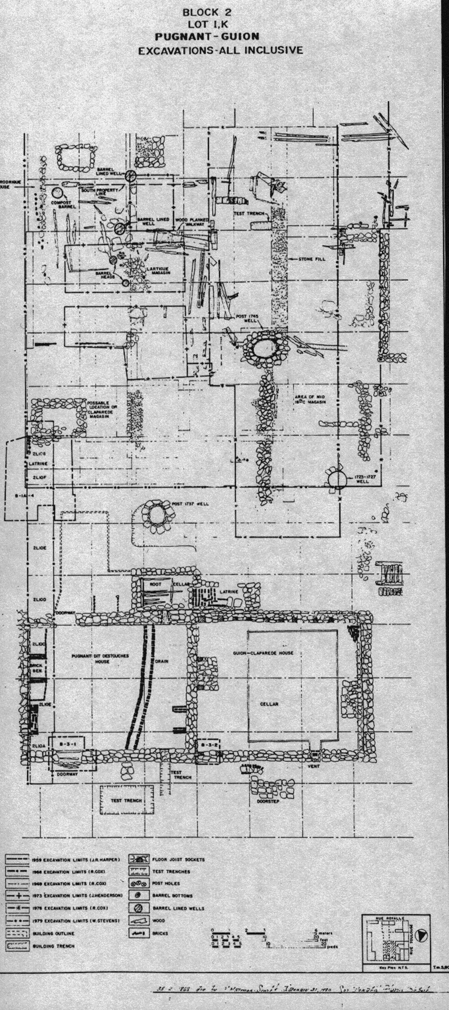
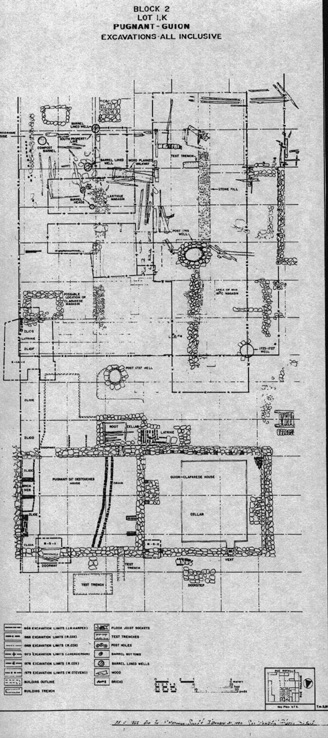
Block 2 - Lot I - Pugnant Property ...
Historic Synopsis ...
1721-37: ...
[236]
In 1737 a fire swept the buildings along the rue du Quay of Block 2 and Pugnant's [Lot I] house was destroyed along with those of his neighbours, Rodrigue [Lot H] and Guion [Lot K]. Pugnant built a masonry house on the site of the burned house almost immediately after the fire ...
[237] ...
Archaeological Investigations
Archaeologists: J. Russell Harper (1959)
Two areas were excavated on the Pugnant property by Harper in 1959 . The first was an area near the western side of the Prevost extension ... the first was relatively large, encompassing a part of the yard of the Commissaire-Ordonnateur's property as well as that of Pugnant. Within this area a deep pit was excavated. This is believed to have been a latrine [Lot H Latrine - Archaeology: B-1A-4 ~ Archaeology: 2L10F, 2L10G] located in a small building shown at the southwest corner of the Prevost extension on the Sproule plan of 1767 [1767-1] ... [Harris neglected to describe Harper's possible Prévost portion of the Lot H/I Fence - Archaeology: Prévost portion of 2L28-29-30Q22/ Archaeology: 2L28-29-30Q22]
[238]
Latrine B-1A-4 ...
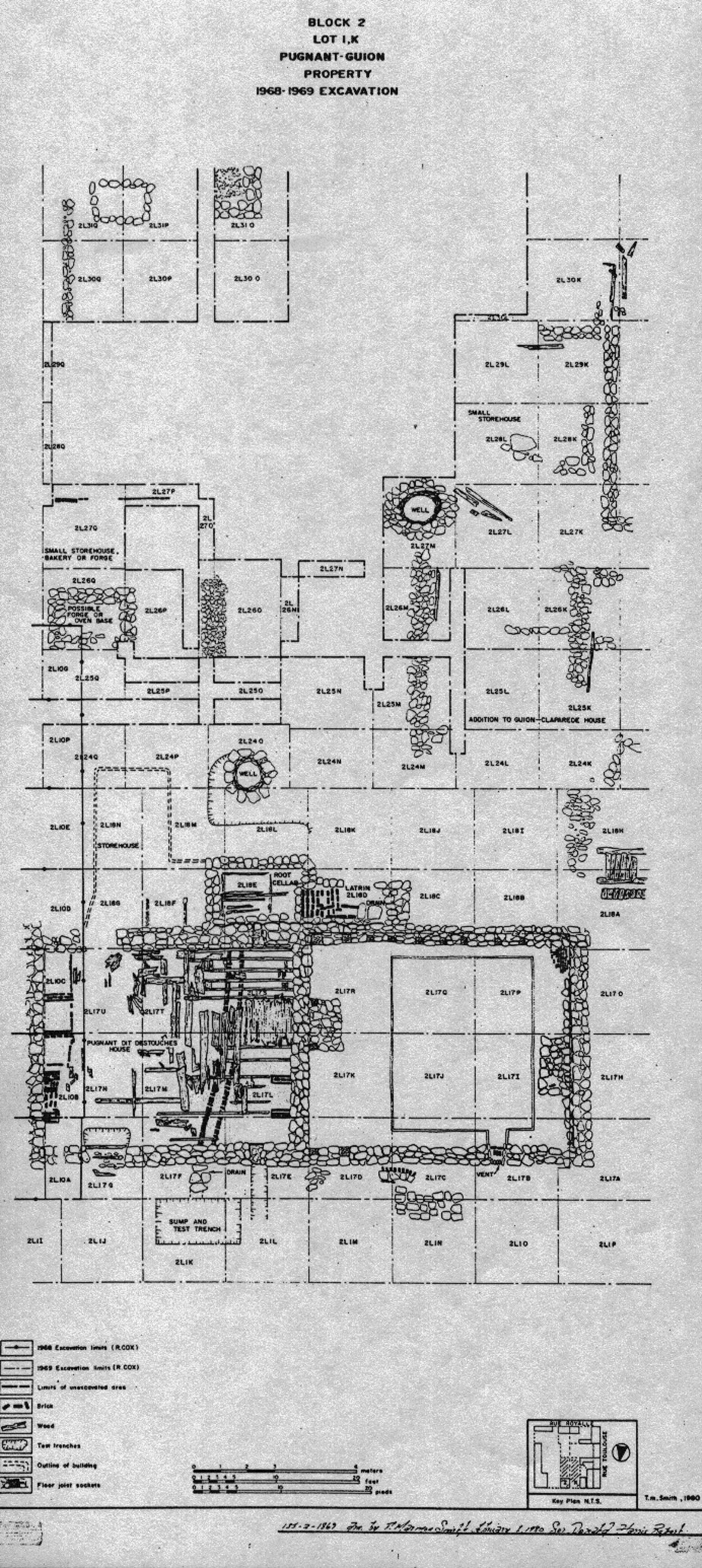
Archaeologist: Richard E. Cox (1969)
The 1969 excavations consisted of extensive investigations of all the Pugnant dit Destouches house and the yard with the exception of the southernmost end ... Other yard features uncovered in the 1969 excavations were ... the eastern boundary fence [Lot H/I Fence - Archaeology: Prévost portion of 2L28-29-30Q22/Archaeology: 2L28-29-30Q22] which separated Lot I from Lot H ...
Yard
2L24-270-Q
2L24-270-Q
2L28, 29Q
[239]
2L3O0-Q ...
[239] ...
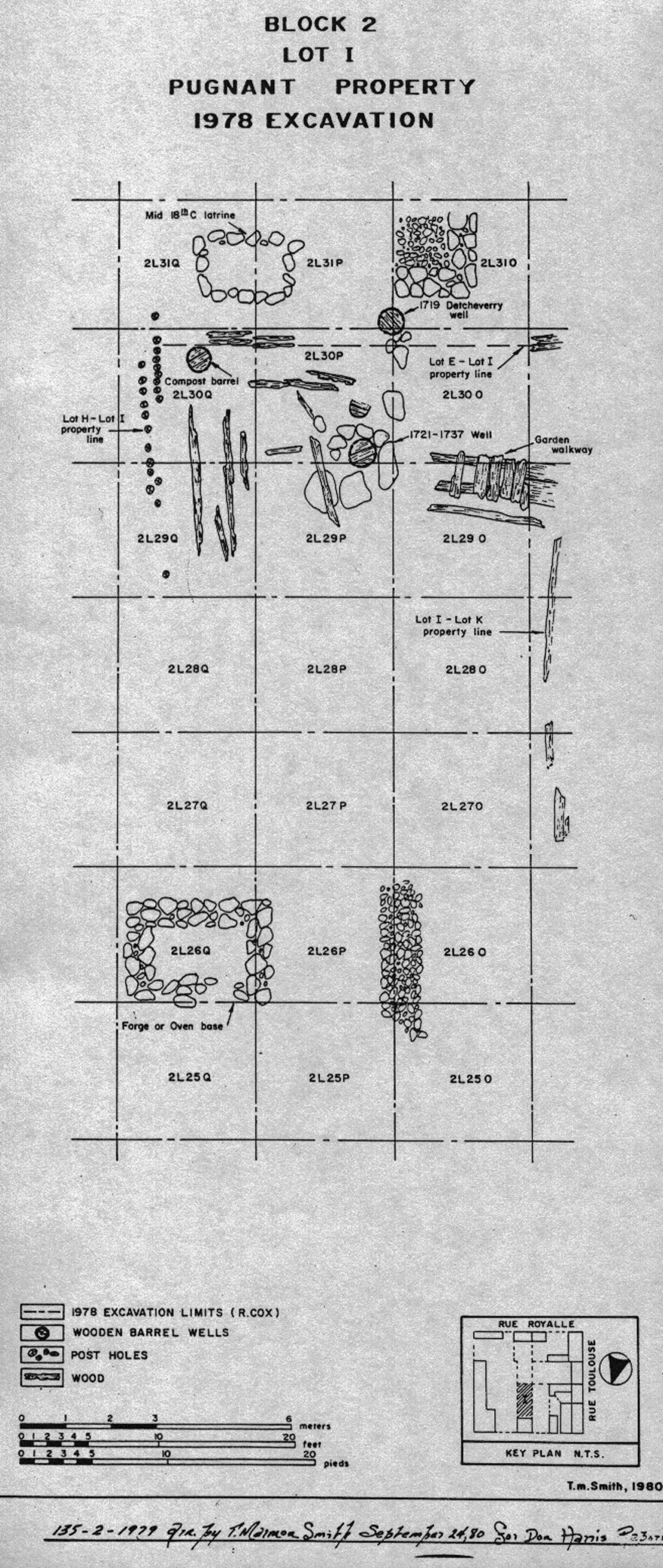
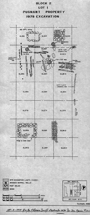
Archaeologist: Richard E. Cox (1978)
The 1978 excavations concentrated on the yard of the Pugnant property, principally in those areas that had not been previously excavated or had been only partially excavated ...
Yard 2L25-30O-Q
[Note: Harris neglected to describe (or provide his re-interpretation of) the possible Lot E/I property fence to which Cox referred and to which I have annotated: "At Louisbourg, the general boundary or garden fence was of piquet construction. A fence leaving remnants of boards would have been highly unusual."]
Archaeological Synopsis ...
[240]
1721: In 1721 Pugnant was conceded the 30 by 100 pieds lot that was to remain in his or his family's hands throughout both French occupations ... At the time the enlarged lot was conceded to Pugnant, he lost at least 6 pieds of land on the eastern boundary to Rodrigue on Lot H. This property loss resulted in Pugnant having to remove part of the eastern end of his house (2II5), an event which probably occurred at the time of the re-alignment of the house or shortly thereafter ...
[241] ...
1737-38: ... In October 1737 a fire swept through the Lot I house destroying it along with several of its neighbours (2II3), but immediately afterwards Pugnant began to rebuild. This time he constructed a masonry building (2II2) that filled the 30 pieds frontage of his property and extended southwards approximately 24 pieds ...
One final point concerns the eastern boundary fence [Lot H/I Fence - Archaeology: Prévost portion of 2L28-29-30Q22/ Archaeology: 2L28-29-30Q22] which could have been erected as early as 1721 (2I38). After the 1737 fire, the widow Rodrigue, along with her new husband, had built a small house [Lot H 3rd Rodrigue House - Archaeology: c. 2L9F,G,M,N; 2L12A,B] on Lot H. This house and property, shown on a plan of 1739, was enclosed by a fence [Lot H/I Fence - Archaeology: Prévost portion of 2L28-29-30Q22/ Archaeology: 2L28-29-30Q22] which was located in approximately the same position as that which was found. This, however, does not mean the fence was erected in 1739, but it may be an indication that it has a later date than 1721 ...
[Note: The 3rd Rodrigue House was actually built further south of where the Lot H/I property fence was found.]
[242] ...
1750-57: ...
[243] ...
It is possible that the latrine [Lot H Latrine - Archaeology: B-1A-4 ~ Archaeology: 2L10F, 2L10G] located adjacent to the west wall of the Prevost extension was dug by Jean Claparede (2I50) but this too is uncertain. All that is known with any certitude is that the latrine was dug after the construction of the Prevost extension which occurred in 1754. It was in use (2I49) from the time of its construction up through at least 1767, when it was shown on the Sproule plan [1767-1]. When it was filled and demolished is not known and because of the way it was excavated by Harper it is possible to determine this date from the artifacts ...
[Plan 1739-1 places in great doubt the "certitude" that this latrine was dug in 1754 or later.]
[244]
1758-67: ...
... ash was found ... in the latrine [Lot H Latrine - Archaeology: B-1A-4 ~ Archaeology: 2L10F, 2L10G] which Harper describes as containing ash ...
1767-84:
... the latrine [Lot H Latrine - Archaeology: B-1A-4 ~ Archaeology: 2L10F, 2L10G] was no longer in use and had begun to accumulate ash (2I48); the fence [Lot H/I Fence - Archaeology: Prévost portion of 2L28-29-30Q22/ Archaeology: 2L28-29-30Q22] had collapsed (2I47) ...
[245]
Remarks
Of the Block 2 properties excavated in 1969, the Pugnant dit Destouches property is one of the better recorded ... There are still a number of unexplained features in the yard but there are some reliable contexts for analytical purposes. The one major element excavated that lacks provenience data was the latrine [Lot H Latrine - Archaeology: B-1A-4 ~ Archaeology: 2L10F, 2L10G] dug by Harper in 1959. This feature contained a considerable number of artifacts, but as there is no provenience data related to them their usefulness has become quite limited.
ILLUSTRATIONS
(Please click on an image to enlarge it)
[Two Image Sizes]
Block
2, Lots F, G, H
Commissaire-Ordonnateur Property
Excavations All Inclusive
|
|
|
| Small | Large |
-----
Block
2, Lots I, K
Pugnant [Destouches] - Guion
Excavations All Inclusive
 |
|
|
Small |
Large |
Block
2, Lot I,K
Pugnant [Destouches] - Guion Property
1968 - 1969 Excavation
 |
|
|
Small |
Large |
-----
Block
2, Lot I
Pugnant [Destouches] Property
1978 Excavation
 |
|
|
Small |
Large |
-----
Block
2, Lot E
Detcheverry - Dugas
Excavations All Inclusive
|
|
|
|
Small |
Large |
-----
Block
2, Lot E
Detcheverry - Dugas Property
1968 - 1978 Excavations
|
|
|
|
Small |
Large |