Bigotyard
Website Design and Content © December 14, 2001, by
Eric Krause, Krause House Info-Research Solutions
(© 1996)
All Images © Parks Canada Except
Where Noted Otherwise
Researching the
Fortress of Louisbourg National Historic Site of Canada
Recherche sur la Forteresse-de-Louisbourg Lieu historique national du Canada
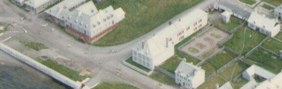
Fortress of Louisbourg, Block Two,
Lots F/G/H Properties:
Landscape Arrangements as of 1744
REPORTS
BACK
Chronological Index ~ Annotated Extracts from Historical and Archaeological
Reports of the Fortress of Louisbourg, 1959 - Present
Note: [...] represent Krause Annotations
Brenda Dunn, Block 2, Lot G, Property of the Commissaire, Unpublished Report HD 14R (Fortress of Louisbourg, 1969) - Extracts [Please Note: The entire report is available at HD14R]
...
[1]
A. First Phase 1721-1735
1. Chronology ...
[2]
Everything being in order, deMesy began to pour the foundations of his house in the spring of 1721 ...
[4]
In 1733 and 1734, the Ordonnateur's property measured 36 pieds along the Quay and 150 pieds along the Rue St. Louis ...
The
Ordonnateur's house was 36 pieds by 26 pieds, a relatively small
structure for a King's building ... In 1735, LeNormant received permission to
"make offices and other changes necessary for the service" ...
LeNormant's improvements drastically altered the Ordonnateur's house, taking the
building into its second phase ...
[7]
B.
Second Phase House. 1736-1754
1. Chronology
(a) 1736-1745
...
Knowing that the King planned to enlarge the Ordonnateur's house, the widow Rodrigue offered to contribute the 4 pieds passageway, located between her house and the Ordonnateur's dwelling, which led to her backyard ... On May 9, 1736, LeNormant and the widow signed an agreement. A masonry wall common to the lot G and lot H houses was to be built by the King, replacing the east end wall of the widow's frame house. The total area surrendered by the widow Rodrigue measured 5 pieds along the Quay, including the thickness of the common masonry wall, and 46 pieds into the Block. LeNormant agreed to maintain and guarantee the passageway on ground floor level, between the west end wall of the first phase house and the new common wall. The Ordonnateur's apartment on the first storey was to extend across the passageway. The Ordonnateur agreed to pay for the construction and maintenance of the common wall. The widow Rodrigue was to receive 300 1ivres and payment for anything broken accidentally during the construction period. In addition, LeNormant was compelled to build [new] latrines [Lot G/H Latrines - Archaeology: B-1B-1-5 ~ Lot G/H Latrines - Archaeology: 2L4E], backing the Ordonnateur's [new] latrines [Lot G/H Latrines - Archaeology: B-1B-1-5 ~ Lot G/H Latrines - Archaeology: 2L4E] in the yard, just within the south boundary of the awarded 46 pieds. A covered drain was to conduct the water from the yard through the latrines, along the passageway, to the sea ...
[8]
In 1736 the Ordonnateur's property was extended to include lot F. (See plan 734-5.) The property, as described in the 1734 Etat, ran 69 pieds along the Rue Royalle and 48 pieds along the Rue St. Louis ...
Francis Bigot took up residence in the Ordonnateur's house after his appointment in 1739 ...
[9]
The Rodrigue property was finally captured by the Ordonnateur in 1741. A fire destroyed Rodrigue's lot H buildings in 1737 ... In 1738, Verrier suggested that the Rodrigue lot be incorporated into the Ordonnateur's property. A freeze was put on the property which forbade the Rodrigue family to build on it or to sell it, forcing them to rent a house and storehouses elsewhere ... Finally, on September 5, 1741, the Rodrigue property was purchased for 5500 livres ... The newly-acquired lot ran 44 pieds along the Quay and 150 pieds into the interior of the Block. The 1736 latrines [Lot G/H Latrines - Archaeology: B-1B-1-5 ~ Lot G/H Latrines - Archaeology: 2L4E] and passageway, and a frame [charpente] house [Lot H Rodrigue 3rd House - Archaeology: c. 2L9F,G,M,N; 2L12A,B] were included in the sale ...
[10]
1749-1754
... Agitation mounted for a west addition. In 1754 construction began, taking the building into its third phase ....
[11]
2. Structural Details ...
When first constructed, the west extension was an enlargement of only the first storey. (See Second Phase Chronology.) While the passageway existed, the Ordonnateur's house had two west end walls--the original first-phase end wall which formed the east wall of the passageway, and the common second-phase wall shared with the Rodrigue house, which formed the west wall of the passageway and the end wall of the apartment above. Toothing stones (Pierre d'attente) were left at the extremities and the middle of the common wall to easily accommodate as an end wall if the widow Rodrigue ever wished to replace her wooden house in lot H with a masonry structure ...
[14]
Latrines
-
Prior to its annexation in 1736, lot F was being used by the Ordonnateur. It
seems that latrines were situated there
[Lot
F Building - Archaeology: 2L15Q
~ No latrine pits were found]
In 1736, latrines were located behind [actually, within the south boundary of the surrendered passageway of] the house. The agreement between the widow Rodrigue and the Ordonnateur stipulated that a [new] latrine [Lot G/H Latrines - Archaeology: B-1B-1-5 ~ Lot G/H Latrines - Archaeology: 2L4E] was to be built for the widow, backing the Ordonnateur's [new] latrine [Lot G/H Latrines - Archaeology: B-1B-1-5 ~ Lot G/H Latrines - Archaeology: 2L4E], just within the south boundary of the passageway. The two latrines were to share a common pit and a covered drain ...The Rodrigue's passageway latrine was included in the sale of lot H in 1741 ... It is not known how long the passageway latrines were functional ...
[23]
C. Third Phase 1754-
The Ordonnateur's house entered a third phase in 1754 when an addition was built on the west end of the building ...
[26]
2. Structural Details
(a) West Addition
2. Structural Details
(a) West Addition - Two walls running parallel to the Quay were erected to form the west addition. The west extremity of the Ordonnateur's house and the east extremity of the Destouches house, located further along the Quay side of Block 2, served as end walls, as suggested by Franquet ... (See plans 739-5-(2) and 767-1.) The toothing stones placed at the ends and middle of the west common wall in 1736 would have been used in the construction of the addition ...
[27]
... There is no way to determine historically the details of the 1754 addition. Verrier's 1739 plans ...
The structure proposed by Verrier was to measure 43 pieds along the Quay and 46 pieds into the Block, abutting for a width of 26 pieds against the Destouches house on the plans. [See plans 739-5 and 739-5a.] ...
[30]
Doors
... A small square [Lot H Latrine - Archaeology: B-1A-4 ~ Archaeology: 2L10F, 2L10G] projects into the Destouches property on the south section of the west wall on plan 767-1, possibly indicating the location of a door. Clough's c. 1759 sketch locates a door in this position ...
[32]
II. MAGASINS OF THE COMMISSAIRE ORDONNATEUR
A. Chronology
M. deMesy began constructing a magasin on lot G in 1720. (See plans 720-2 and 720-4.) It was situated, in alignment, along the Rue St. Louis boundary. By June of 1721, the building had been completed ...
[42]
III. OUTBUILDINGS
...
[43]
B.
Stables
Bigot erected a stable in the Ordonnateur's yard in 1739 to store poultry,
sheep, and "other things necessary for nourishment" ... It was situated
in the southwest corner of the property, along the Rue Royalle ...
[44]
By 1741, the stable had extended along the Rue Royalle to the corner of the Rue St. Louis, running the entire length of the south boundary of the Ordonnateur's property. (See plans 741-2, 744-5, and 745--11.) The extension shown is wider than the original building ...
[45]
C.
Dove-cote
[Lot F Dovecote - Archaeology: No evidence]
In 1741, a colombier* or dove-cote
was built in the Ordonnateur's
yard
...The
dove-cote was located in the southwest part of the yard, just in front of the
[French] stables. (See Clough's c.1759 sketch.) Plans 744-5, 745-11, 746-8, and 767-1
show a small square building in this approximate position ...
[Note - If the relatively small feature on 1744-5 and 1745-11 is a dove-cote, then on 1746-8, and 1746-8a the dove-cote is not the feature immediately to the east of the larger feature [Lot E/H English Stables - Archaeology: 2L31O,2L32O,P]. Rather the small feature is an unknown pre-existing Lot H asset. Significantly, archaeology has confirmed the Lot E/ H English stables at this approximate position.
If the larger feature on 1751-7, 1751-8, 1751-10a, and 1751-17a is the dove-cote, then the smaller feature to the south is either one of two possible Lot H wells: The Lot H Well - Archaeology: 2L14V or the central Lot H Well - Archaeology: B-1C-1 ~ Archaeology: 2L13V whose location is more accurately illustrated on 1751-8.
The larger feature on 1767-1a with the smaller feature to the east has no doubt been placed too far south on this plan since their combined configurations certainly mimic the same as shown on plans 1746-8, and 1746-8a. In this scenario, these features would then be the same Lot E/H English stables complex and unknown feature to the east of it.]
D. English Stable
[Lot E/H English Stables - Archaeology:
2L31O,2L32O,P
- Note: Harris placed the west portion of this feature on Lot E
- See Harris,
'82 Town]
The English reported that they had made "Several additional outhouses" at the "Intendance"
during the Occupation. [66] The only new building mentioned [specifically
identified by the number 15 on 1746-8a], however, was a "New House for Stock". (See plans 745-23 and 746--8.) What seems to be the English stable appears on plan
767-1. A small projection [Lot H Well - Archaeology: 2L14V], similar to these on other buildings on the plan, is shown on the
northeast corner of the wooden structure.
[Note: The exact quote is: " 15. New house for Stock at the Governors." and on site plans the archaeological location is given as c. 2L31O,2L32O,P. According to Harris, this placed the English stables on Lot E immediately south of what archaeology has assumed assumed to be the Lot E/I property line, and but a short distance from the assumed Lot H/I property line where the lot H/I property fence post remnants were excavated and identified as 2L28-29-30Q22. Archaeology exposed only the ell of the north-west corner of the stables, suggesting that the main body lay south and east of this corner - as far as Lot H - with its south wall sited perhaps just north of the Lot E well 2L14W.
However, Dunn here places this feature on Lot F and not on Lot E. For the purposes of this study, I have placed the stables as being Lot E/H English Stables - Archaeology: 2L31O,2L32O,P since some historical plans and the Harris archaeological interpretation both suggest that this feature extended east and west of the property line, but upon Lot H and not upon Lot F]
[47]
IV YARD
A. Gardens
[and Garden Fences ~ Lot F/G/H Garden - Archaeology: No evidence]
Almost nothing is known about the gardens of the Ordonnateur's property.
Several plans of the first-phase Ordonnateur's house situate a garden at the
rear of the lot G property. A cultivated area is seen in the southwest corner of
the lot on plans N.D.7 and N.D.7a. Plan 731-3-(1) confines the garden to a
square area behind the south magasin, while plan 734-4 extends it along the west
side of the magasins. Picket fences enclose the garden ...
In 1742, pickets were fashioned to enclose the Ordonnateur's courtyard and
garden ... With the exception of plan 744-5, gardens are not shown on the
plans of the second and third phases of the house. The 1744 garden is situated
on the former Rodrigue property, with an opening in the east wall of its
enclosure.
B. Fences [Fence: No evidence except for the
Lot H/I Fence - Archaeology: Possible Prévost
portion
of
the Lot H/I Fence - Archaeology: Prévost portion of 2L28-29-30Q22/ Archaeology:
2L28-29-30Q22 and the
Lot
F Fence - Archaeology: B-1D-1 ~ Archaeology: 2L7A-E]
In the first phase of the deMesy house, a picket fence ran along the west,
south, and partially along the east boundaries of the property, enclosing the
courtyard and the garden. (See plans N.D.7, N.D.7a, and 731-3-(1).) Entrance to
the property was gained through a [assumed] masonry wall [Lot
F Fence - Archaeology: B-1D-1 ~ Archaeology: 2L7A-E] which ran between the house and
the storehouse. (Also see plan 731-1.)
A picket fence between the west wall of the south magasin and the west boundary
of the property formed the north wall of a garden at the rear of the
Ordonnateur's yard. (See plans N.D.7, 731-3-(1), and 734-4.) The area of the
garden and the location of this section of the picket enclosure vary on the
plans.
The property to the rear of the Ordonnateur's house (lot F) was enclosed
following its acquisition from St. Ovide in 1736 ... Plan 739-5-(1) shows a
picket fence along the east, west, and Rue Royale south boundaries.
[48]
The Rodrigue property (lot H), which was added to the Ordonnateur's property in
1741, was encompassed by pickets ... As seen on plans 739-5, 739-5a,
740-3,741-2, and 742-6, the west perimeters of both lots G and H were very
irregular. A proposed masonry wall, enclosing the proposed prison on lot H is
shown on plans 739-5-(1) and 739-5a. It is likely that the section of picket
fence between the two properties was removed after the two were incorporated.
The entrance to the Ordonnateur's yard was situated behind the south magasin on
the Rue St. Louis after the transition to the second phase of the house. (See
plans 739-5-(1), 746-5, and 746-8) An entrance was also shown on the Quay front
of the former Rodrigue property on plans 746-5 and 746--8. Plan 745-1 situates a
picket fence across the Quay front of the lot H property.
The expenses for 1742 included pickets which had been furnished to enclose the
Ordonnateur's courtyard and gardens ... In 1750, masonry and pointing repairs
were made to several parts of a fence [Lot F Fence - Archaeology: B-1D-1 ~
Archaeology: 2L7A-E] at the Ordonnateur's house ...
[Note: The exact quote is:
Reparation en Maçonnerie et Crepissage faitte pour plusieurs parties, Sur Le mur de Closture et terrasse de Brique au pourtour de la maison, Estimé pour fourniture et façon a qharante Cinq Livre Seize sols, Cy ... 45: 16: 0 ..."
Fences on the east [Lot F Fence - Archaeology: B-1D-1 ~ Archaeology: 2L7A-E] and west [Lot H/I Fence - Archaeology: Possible Prévost portion of the Lot H/I Fence - Archaeology: Prévost portion of 2L28-29-30Q22/ Archaeology: 2L28-29-30Q22 and Lot E/F Fence - Archaeology ?] boundaries of the Ordonnateur's property are seen in Gibson Clough's c.1759 sketch. The diagram includes interesting sketches of two gates, one located in either wall. No other plan shows an opening in the west boundary. Clough's sketch and plan 758-9 situate a fence on the Ordonnateur's terrace, overlooking the Quay and running up the Rue St. Louis ...
[Note:
The fences illustrated an a number of plans (for example, 1740-3, 1741-2,
1746-6, 1745-11) is, of course, for the proposed jail, Superior Council,
etc., illustrated on plan 1739-5 and 1739-5a. This fence and building
complex was never constructed.]
C. Terraces
1. Plans N.D.7 and N.D.7a show pavé
[Lot
G Pavé
- Archaeology
B-1C-2 ~ Archaeology: 2L8B,C,E,F,H,I; 2L12G,N,T,U; 2L13G,N,U; 2L14G,N,U]
extending along
the west wall of the magasins. This feature does not appear on any other plan
...
2. Pavé ...
[49]
In 1742, the land around the Ordonnateur's house was lowered to the terreplein
level of the Quay ... A bank, eight pieds wide, was left around
the dwelling. (See plans 743-1.) ...
[50]
D. Wells
Several wells were located on the Ordonnateur's property throughout its history.
1. Plans 731-3-(1), 734--4, N.D.7 and N.D.7a show a well [Lot G Well - Archaeology:
2L8A] on the west boundary of
the Ordonnateur's property, opposite the west wall of the north magasin. It is
wood-framed and has a scaled diameter of about 3 pieds. (Scaled from
N.D.7.)
2. When Bigot became Ordonnateur in 1739, he complained that his Block 2
establishment did not have a well [This was exaggeration, since the
Lot G 2L8A well must have existed since c. 1721-1725] ... A new one [Lot F Well - Archaeology: 2L7B,C] had been made by December ... The 1739 well was situated on the east boundary of the property,
between the south magasin and the Rue St. Louis courtyard entrance. (See plans
739-5-(1), and 739-5a.) The well was enclosed, either partially or completely,
by a structure with a hipped roof. Plans 739-5-(1) and 739-5a show an
opening on the west side of the well house.
The well was in existence until at least the first siege, for it appears on
plans
740-3, 744-5, and 745-11.
3. A new well [Lot
H Well
- Archaeology: B-1C-1 ~ Archaeology: 2L13V] was excavated in the Ordonnateur's yard after the French
reoccupation in 1749. [68-18 to 22] The 1749 repair toisé stated that
the excavation was 6 toises 3 pieds, presumably cubic [pieds]
measurement.
Seven [cubic] pieds of [rubblestone, not brick] masonry were used in the well. There is no way of knowing
how far the masonry extended above ground level. If the well had a diameter of 3
pieds, there would have been 5 1/2 pieds of masonry below ground
level and 1 1/2 pieds above. Sixty cubic pieds of lumber [timber] were used for the roof
[frame] and its supporting [vertical] posts over the well. Six square toises
2 pieds of Boston planks [c. 1 pouce not 2 pouce thick
boards] covered the roof. [Also - there was a charge for 8 work days
pumping out water so that the well could be excavated].
The location of the well is not given on the plans. Possibly it was one of the
wells shown either on the Gibson Clough sketch or the 767-1 plan. (See below.)
[This well no doubt also appears on Plans 1751-8. It may also appear on Plans 1751-7, 1751-10a and 1751-17 if this is not the Lot H Well - Archaeology: 2L14V.]
[51]
Gibson Clough's c.1759 sketch situates a pulley-operated well in the northwest
corner of the Ordonnateur's yard
5. Plan 767-1 locates a well [Lot
H Well
- Archaeology: B-1C-1 ~ Archaeology: 2L13V] in the Ordonnateur's yard at the right-angle turn
in the west boundary ...
[Note - See also: 1751-8 which may also illustrate this new well.]
[6]. [Plan 1767-1a illustrates a feature at the location of the Lot G Well - 2L8A. It might suggest a covered well.]
[Footnotes/Endnotes]
...
[28b] [G3, Volume 2039s, 9 May 1736]
[Lot G/H Latrines - Archaeology: B-1B-1-5 ~ Lot G/H Latrines - Archaeology: 2L4E]
...Comm'aussy de faire faire a l'extrémité et en dedans des quarente six pieds du dit terrain des latrines qui appartiendront a la demoiselle Rodrigue, adossées a Celles de la maison du Roy, dont la fosse sera Commune ...
[34] [C11B Volume 18, December 29, 1736, f. 286]
[Lot G/H Latrines - Archaeology: B-1B-1-5 ~ Lot G/H Latrines - Archaeology: 2L4E]
... M. LeNormant adresse a Votre Grandeur l'Etat de la depense des amenagements quil a fait faire a la maison du Roy quil occupe ... tous les amenagements qui ont estés faits dans cette maison estoient indispensable, il ny avoit point de Lattrines ...
[44] [C11B Volume 21, September 14, 1739, f. 95v]
[Lot F Well - Archaeology: B-1D-1 ~ Archaeology: 2L7B,C]
... Jay trouvé, Monseigneur, en bon Estat La maison de L'ordonnateur ... n'en ayant point trouvé dans la maison, non plus que depuits, ny d'amenagement pour les provisions d'hiver, comme de betail et de volaille ...
[46] [C11B Volume 21, December 19, 1739, f. 268]
[Lot F Well - Archaeology: B-1D-1 ~ Archaeology: 2L7B,C and Lot F Basse-cour - Archaeology: No evidence]
... dans celuy de mr. Bigot pratiquer ... un angar fermé dans la basse Cour pour mettre a couvert la Volaille, moutons, et autres choses necessaires pour La nouriture, et un puis, par le moyen de ces reparations ces mrs. ce trouvent Logés plus Commodement ...
[57] [C11C Volume 12, 1742, f. 95v]
[Lot F Basse-cour - Archaeology: No evidence and Lot F/G/H Garden - Archaeology: No evidence]
...
4 sept Certifficat Ordonnance et Quittce. aud.
Duran pour
facon de palissades qu'il a fait au pourtour du
jardin et de la cour occupé par l'ordeur
91: 5: 0 ...
[66] [Nova Scotia A, v. 34, July 14, 1749, f. 162-163]
162
... The Intendance where the English Governours [163] have lived since the Place belonged to them ... Several additional outhouses made ...
[68b] [C11B Volume 29, December 31, 1749, ff. 347, 348]
[Lot H Well - Archaeology: B-1C-1 ~ Archaeology: 2L13V]
Maison
dy Roy ou
loge Monsieur L'ordonnateur ...
...
Excavation d'un puit dans la cour contient Suivant
le toisé qui en a esté fait 6to - 3 - 0 Estimé 9# la
toise cube
cy
58: 10: 0
La
Maconnerie faitte dans ledt puit se monte suivt le
toise qui en a esté fait a 1to - 1 - 0 po Estimé 120#
la toise cube
cy
140: 0: 0
60
pieds cubes de charpente employés en potteaux
comble de la couverture du puis, Estimé 20s le pied
cube
cy
60: 0 0
6
toises quarré et 2 pieds de Couverture de planches
de baston estimé 6# 10s la toise quarrée
cy
41: 3: 4
huit
Journées Employée a l'Epuissement des eaux pour
faciliter l'approfondissement dud. puits a 25 sols par
jour
cy
10: 0: 0 ...
[73b] [C11B Volume 29, December 31, 1750, f. 102v]
[Lot H Latrine/ Cistern - Archaeology: 2L12V]
... Vingt-deux Journées et demye Employés a L'Excaon d'un Bassin [Bassin - Archaeology: ?] utile a La Basse Cour [Lot H Basse-Cour - Archaeology: No evidence] a 20 Sols par Jour Ensemble vingt deux Livres dix sols Cy ... 22: 10 0 ...
[The cistern [Lot H Latrine/Cistern - Archaeology: 2L12V] existed on Lot H, and was therefore constructed by either the Lot H owner before 1741, or by the Lot G owner after 1741. Of the three drains which serviced it, two existed on Lot H, but one - the southern drain - began in Lot F, and crossed Lot G before entering Lot H. One interpretation might be then that the cistern was therefore constructed after 1741, and indeed, might be the "bassin" of 1750]
[Bassin, se dit aussi des lieux preparez dans les jardins pour recevoir les eaux des sources & des fontaines jaillissantes - Furetière, Dictionnaire Universel contenant généralement tous les mots Français tant vieux que modernes et les termes de toutes les Scienes et des Arts (Geneve, Slatkine Reprints, 1970)] ...