Bigotyard
Website Design and Content © December 14, 2001, by
Eric Krause, Krause House Info-Research Solutions
(© 1996)
All Images © Parks Canada Except
Where Noted Otherwise
Researching the
Fortress of Louisbourg National Historic Site of Canada
Recherche sur la Forteresse-de-Louisbourg Lieu historique national du Canada
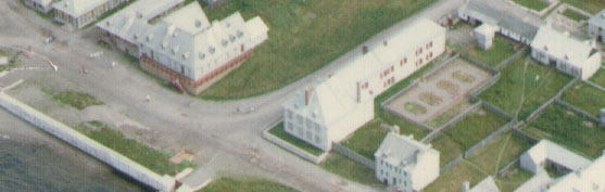
Fortress of Louisbourg, Block Two,
Lots F/G/H Properties:
Landscape Arrangements as of 1744
REPORTS
BACK
Chronological Index ~ Annotated Extracts from Historical and Archaeological
Reports of the Fortress of Louisbourg, 1959 - Present
Note: [...] represent Krause Annotations
Brenda Dunn, Block 2, Unpublished Report HD 17R (Fortress of Louisbourg, September 1971, Revised 1978) - Extracts [Please Note: The entire report is available at HD17R]
...
Lot E [Detcheverry-Dugas]
...
(A) PROPERTY AND FIRST HOUSE (c.1719-c.1728):
What was to become Lot E is first seen on Plan 1720-2; a building is located in the
interior of the block and a garden faces the Rue Royalle ...
Although the 1723 etat described Detcheverry as the owner of Lot E, his claim to the property was threatened by a royal ordinance issued from Versailles in May of that year. The ordinance of 1723 included Detcheverry in the list of two blacksmiths and one tavern keeper who were occupying Quay front properties in Block 2 to the alleged detriment of fishermen ...
Between the time that the ordinance was issued and registered, Detcheverry requested and received a concession of Lot E. This concession of 8 June 1724 did not mention a previous concession. The property conceded in 1724 was bounded on the west by Sabatier (Lot D) and on the north by Rodrigue (Lot H), and ran 46 pieds along the Rue Royalle and 60 pieds into the block ...
The building in the interior of Lot E, referred to in the Detcheverry-Verdon rental agreement as the vieille maison, does not seem to have survived long after 1726. No documentary reference to the structure has been found after 1726, and the last town plan to show it is 1724-2. It is probable that the building was destroyed in 1728, when Verdon's lease expired and Joseph Dugas became the sole owner of Lot E ...
[Note: No doubt, Lot H captured a portion of the property on which the skewed house sat. See below for the thread of this discussion]
(B) FIRST HOUSE -
STRUCTURAL DETAILS:
Detcheverry's first house served as both his residence and place of work. In
1726 the building consisted of "une boutique forgé, cuisine cabinets &
autres appartenances et dependences" [NOTE 9]. It is possible that the
forge was located in the extension shown on the north wall of the building on
Plans 1722-1, 1723-2, 1723-3, 1723-4 and 1724-2.
The building was a rectangular [skewed] structure located in the interior of Block 2 [and positioned in 1722/1723 nearly completely north of the Lot F/G/H property line to the east, and of the Lot D/E line to the west. The conceded Lot F/G/H property line in 1720 was 60 pieds from Rue Royalle, 54 pieds in 1724, and 48 pieds in 1734. The conceded Lot D/E line was 60 pieds in 1721 and c. 55-60 pieds in 1734/1735. To the north, the conceded Lot E/H/I property line stood 60 pieds from Rue Royalle in 1724, but in a different configuration in 1734, the conceded Lot E/H property line had decreased to 48 pieds while the Lot E/I line had increased to 98 pieds. Clearly, this building site, which in 1722/1723 once stood almost, if not entirely, beyond the conceded Lot E property, was partially brought to conceded Lot E property in 1734. According to Plan 1734-5 and Vallée's accompanying property descriptions for Lots C/D/E/F/H/I/K, it can be calculated that sometime after 1724-1731 and before 1734, Lot H had gained from Lot E a piece of 1724 property that measured 12 pieds along its west boundary line and 10 pieds along its south line.] ...
[For this skew, see, for example, plans 1722-1, 1723-2, 1723-3, 1723-4, and 1724-2: The skewed interior Lot E Detcheverry 1st House (c.1719-c.1728) was in the same similar line as the skewed Lot H Rodrigue 1st House (c. 1714-c.1724) then straddling the Quay.]
C) PROPERTY AND SECOND HOUSE (1722-68):
A formal agreement between Dominique Detcheverry and Joseph Dugas in October of 1722 provided for the construction of a double house on the south boundary of Lot E, facing the Rue Royalle ...
The house was built by 1723 ...
The size of the property increased between the 1724 concession and the 1734 etat. In 1734 the south boundary along the Rue Royalle was 51 pieds, the east boundary to Lot H was 48 pieds, and the west boundary to Lots I and K was 98 pieds. (See Plan 1734-5) ... [The E/I boundary line measured 30 pieds]
[The exact description was as follows:
à feu Joseph Dugas habitant, un terrain occupé par sa veuve de 51 pieds de face sur la ruë Royalle et de profondeur sçavoir 48 pieds jusqu'au terrain de la veuve rodrigue, et 98 pieds jusqu'au terrain de nicolas pugnant et de baptiste dyon, borné au nord par les terrains dudit baptiste dyon, et de nicolas pugnant, et par celuy de laditte veuve rodrigue, et à l'est par le terrain de feu michel rodrigue, et par un terrain non concédé; au sud par la ruë Royalle, et à ouëst par les terrains des Srs andres carrerot, et benoist, ledit terrain acquit par le feu Sr joseph dugas de dominique chevery, forgeron, qui en avoit la concession de messrs de St ovide et de messie du 24e may 1722. Contenant en superficie cy... [marge de dr.:] 4248 - [C11B, Volume 15, October 24, 1734, ff. 26-50, as transcribed by Claude Desaulniers (January, 1997)]
[On Plan 1739-5, the property scaled to the following measurements: Rue Royalle: Only a partial width is illustrated; Along Lot H: c. 54 pieds; To the Lot E/I boundary line: c. 92 pieds; Along Lot E/I: Only a partial width is illustrated.]
[The skewed interior Detcheverry first house (c.1719-c.1728) was illustrated at the rear of a property which, five years later, in 1724, was surveyed and conceded as being 60 pieds distant from Rue Royalle along its eastern boundary line. In contrast, in 1734, the surveyed lot measured only 48 pieds along the same eastern line to where it now encountered the Lot H boundary fence. Clearly then, by 1734, Lot H now occupied a portion of the lot E property on which the Lot E Detcheverry first house had been partially built. Not only that, but according to plan 1739-5, the Lot E/H north/south boundary fence had even taken the skewed line of the east wall of the original Detcheverry first house.]
(D) SECOND HOUSE - STRUCTURAL DETAILS: ...
It seems that the [interior] passage had been blocked by 1733, for it is not mentioned in the inventory. When the passage was constructed, the house filled the 45 pieds boundary on the Rue Royalle. By 1734 the passage would no longer have been necessary because the Rue Royalle boundary had been increased to 51 pieds, providing an [eastern] access 6 pieds wide into the yard ...
OUTBUILDINGS AND YARD:
When Lot E was first occupied, a garden extended from the house in the interior of the yard to the Rue Royalle. (See Plan 1720-2). The construction of the house on the Rue Royalle in 1723 reduced the size of the yard ...
[As for the Lot E/H north/south property fence, see, for example, plans 1722-1, 1723-2, 1723-3, 1723-4, and 1724-2: Prior to the resolution of the Lot 2 property fights, the Lot E/H north/south fence line was seemingly perpendicular to the Quay. However, as the later plan 1739-5 illustrates, after resolution, this condition changed dramatically, and a portion of the Lot H/I fence and all of the E/H north/south fence came to take the same approximate angle of skew as the skew of the interior Lot E Detcheverry 1st House and quay front Lot H Rodrigue 1st House.]
In 1726 the Lot E yard consisted of three sections. The land directly behind the duplex was divided into halves which corresponded to the division of the house. In November, Dugas' yard behind the west half of the house was increased to 22 1/2 pieds (E. by W.) by 12 pieds (N. by S.). The east half of the house rented to Latapy in October had a garden which ran 22 pieds (E. by W.) and about 15 or 16 pieds (N. by S.). The remainder of the yard apparently constituted the courtyard on the north side of the first house which was rented to Verdon in May ...
After the first house in the interior of Lot E was no longer in existence, the Lot E yard was divided into a garden at the north end of the property and a courtyard between the garden and the house. (See Plans 1730-2, 1731-3-(1) and 1734-4). A picket fence appears around the perimeter of the yard and between the courtyard and garden on 1731-3-(1) ...
There was a magasin in Lot E by 1733. Plans 1734-4 and N.D. 89 situate a building with a hip roof in the northwest corner of the courtyard adjacent to the garden ...
When the duplex was built, it filled the boundary of Lot E on the Rue Royalle. The passage in the east half of the house was designed to allow direct access from the street to the yard. It seems, however, that Detcheverry was trespassing on Lot F, for in 1726 he stated that the public could use the passage only if a building were erected next to the house, and a passageway "qui Est apresent Sur le derriere du jardin pour aler ala forge" was blocked. By the time of Vallées etat in 1734, 6 pieds had been added to the boundary on the Rue Royalle. A section of picket fence with an opening is shown between the buildings in Lots E and F on Plan 1739-5. If the passage in the house had been blocked by the time of the inventory in 1733, an opening larger than that shown in the picket fence on 1739-5 would have been required for the horse and cart ...
-------------------------------------------------
Lot F [Genier-St. Ovide-Stables of the Commissaire-Ordonnater]
....
Lot F apparently remained undeveloped until at least 1730 . A vacant property, with neither buildings nor a garden [Lot F Garden - Archaeology: No evidence], is shown on the town plans between 1717 and 1730. (See Plans 1717-2 to 1724-2 [A garden is clearly illustrated on this plan], 1730-2 and N.D. 6, N.D.7a, N.D. 24) ...
LeNormant may have been using Lot F prior to 1734. Verrier's use of the term "commodities" seems to refer to the proposed improvements, although it is possible that it refers to latrines which were already standing [Lot F Latrine - Archaeology: No latrine pits were found]. A building [Lot F Building - Archaeology: 2L15Q ~ No latrine pits were found] stood on the west half of the property, fronting the Rue Royalle and running lengthwise into the block, in 1731 and 1734. (See Plans 1731-3-(l) and 1734-4). There is no documentation on the construction and demolition of the structure. Plan 1731-3-(l) shows a solid picket fence on the boundaries between Lot F and Lots E [Lot E/F Fence - Archaeology: ?].
Whether or not he had a building in Lot F prior to 1734, the commissaire-ordonnateur had taken advantage of the unoccupied Lot F property. Lot F's east boundary had gradually decreased in size. The property measured 60 pieds along the Rue St. Louis in 1720, 54 pieds in 1724 and 48 pieds in 1734. Perhaps as compensation, the south boundary on the Rue Royalle had increased; it measured 60 pieds in 1720, 70 pieds in 1724 and 69 pieds in 1734 ...
In November ... of 1736 a letter by St. Ovide and a joint letter by St. Ovide and LeNormant reviewed the situation. By that time ... LeNormant had enclosed and was using Lot F of Block 2. Unfortunately it is not known how he was using the property ...
LeNormant left Louisbourg in 1739. When his successor, François Bigot, arrived, he considered several renovations and improvements necessary in his Block 2 establishment. One of these was the construction of an hangard in Lot F to house poultry, sheep and "autres choses necessaires pour la nourriture" ... The new building appears on Plan 1739-5.
The history of Lot F from its annexation to the commissaire-ordonnateur's establishment is included in the report Dunn' 69 CO ...
-------------------------------------------------
[Lot G (Genier-Commisaire-Ordonnateur - See Dunn' 69 CO]
-------------------------------------------------
Lot H (Rodrigue-Commisaire-Ordonnateur]
...
The Rodrigues' residency in Block 2 was one of constant conflict with their neighbours. Two disputes featured prominently in the history of Lot H. From 1720-22 the Rodrigues suffered their first clash with the commissaire-ordonnateur, their powerful neighbour in Lot G. The second dispute covered a period of 14 years, 1723-37, and involved the Rodrigue family and Joseph Lartigue with the commissaire-ordonnateur and the other inhabitants of the Block 2 Quay front ... [This property alignment and ownership dispute is too lengthy and involved to reproduce here, and for more details go to: Brenda Dunn, HD17R - Lot H and see "Rodrigue-Demesy Dispute (1720-22)" as well as the "Ordinance of 1723 Dispute, 1723-38."]
(A) FIRST RODRIGUE HOUSE AND MAGASIN (c.1714-c.1724)
Rodrigue's first principal building was an L-shaped [skewed] wooden structure composed of a house in the north section facing the Quay and a magasin in the south section running back into the block. ... The 1721 and 1723 letters submitted by Rodrigue to the council referred to "une maison de charpente de 60 pieds ... avec un magasin, un four, une Cour, et un Jardin" and "une maison ... avec un magasin de 60 pieds de charpente." ... The most probably explanation of the evidence is that the house was of charpente construction and the magasin of pickets ...
Concurrently,
Rodrigue was faced with the imminent demolition of his house because it was
outside the boundaries of Block 2 drawn up by Jean-François de Verville
.... A royal ordinance of 1723 ordered Rodrigue to destroy the unaligned section
of his house within one year ...
The demolition took place sometime after 1724. No work was done on the house in
1723. (See Plan 1723-2) ... Plan 1724-2, the last town plan to show Lot H until
1730, includes the Rodrigue buildings ...
[Sometime after 1724-1731 and before 1734 - perhaps reflecting the results of the property fight mentioned below ("Ordinance of 1723 Dispute, 1723-38") Lot H (a fisherman's property) captured a portion of the Lot E (a blacksmith's property) upon which a skewed house (c.1719-c.1728) partially sat (i.e. Lot H gained 12 pieds along its west E/H boundary line and 10 pieds along its south E/H line.) Not only that, but according to plan 1739-5, the Lot E/H north/south boundary fence had even reproduced the approximate same angle of the skewed line of the east wall of the said Lot E house. For the rest of the thread of this discussion, See Lot E above.]
Lot H was recorded in François-Magdeleine Vallée's town survey in 1734. The property measured 48 pieds along the Quay and 150 pieds into the block. ...
[The exact description was as follows:
à feu Sr Michel Rodrigue habitant un terrain de 48 pieds de face sur le quay et de 150 pieds de profondeur, borné au nord par le quay, à l'est par l'emplacement au Roy occupé par l'ordonnateur, au sud par un terrain non concédé et par celuy de feu joseph dugas, et de celuy de nicolas pugnant dit d'Etouches, par concession de messrs de St ovide et de messie du 3e aoust 1716 lequel terrain contient des quantitées de pieds quarrés en superficie cy... [marge de dr.:] 7200 [marge de g.:] occupée présentement par Cavernes [?] ... [C11B, Volume 15, October 24, 1734, ff. 26-50, as transcribed by Claude Desaulniers (January, 1997)]
(B) SECOND
RODRIGUE HOUSE (c.1725-37)
Rodrigue replaced his first house with a dwelling on the Quay front of his newly
aligned property. The structure first appears on an early elevation of deMesy's
Lot G buildings, Plan N.D. 7a. The second dwelling closely resembles the first
in size and shape. (See Plans 1717-2 to 1734-4). It is possible that the second
house was simply a re-assembly of the first structure with certain alterations,
assuming that the first house was charpente as described by Rodrigue.
The second Rodrigue house was of charpente construction ...
(C) SECOND HOUSE
YARD.
A garden
[Lot H Garden - Archaeology: No evidence]
was located at the rear of the second Rodrigue house. (See Plans
1730-2, 1731-3-(l), 1734-4 [N.D. 7, N.D. 7a] and N.D. 24). A picket fence
[No evidence except for
Lot H/I Fence - Archaeology: Prévost portion of 2L28-29-30Q22/Archaeology:
2L28-29-30Q22]
with an opening in its
north side encloses the cultivated area on Plan 1731-3-(l).
[On Plan 1739-5,
this garden would have been positioned in the fenced-off area to the south of
the Lot H 3rd Rodrigue House [Lot H Rodrigue 3rd House - Archaeology: c.
2L9F,G,M,N; 2L12A,B] which was demolished in 1742 after the Lot G capture of Lot
H in 1741.]
A small building [Lot
H Latrine/Cistern - Archaeology: 2L12V]
is seen in the northeast corner of the garden, in the interior
of Lot H, on Plans 1734-4 [Larger, rectangular building] and N.D. 89 [Small,
square building]. It is likely that the building was one of
the "magasins " which was destroyed in the 1737 fire ...
[On Plan 1739-5,
this latrine would have been positioned within the fenced off area
to the east of the Lot H 3rd Rodrigue House [Lot H Rodrigue 3rd House -
Archaeology: c. 2L9F,G,M,N; 2L12A,B]
which
was demolished in 1742 after the Lot G capture of Lot H in 1741.
Previously, this latrine (1725-1736) served the L-shaped Lot H Rodrigue 2nd
House (c. 1725-1737) prior to the 1736 agreement between Lots G/H for a new
commonly-shared latrine complex Lot G/H Latrines - Archaeology: B-1B-1-5 ~
Lot G/H Latrines - Archaeology: 2L4E.]
(D) ORDINANCE OF 1723 DISPUTE, 1723-38 ...
On 2 January 1737 the widow Rodrigue addressed an appeal to Maurepas, in whom she expressed the greatest confidence and loyalty, as had the other supplicants. Her letter vigorously attacked LeNormant. She blamed him for the omission of Lot E from the Etat which enforced the ordinance, stating that the depth into the block of the area originally granted had been greatly reduced, LeNormant having disposed of it to "certain persons" to the prejudice of Lartigue and herself. ... Dominique Detcheverry's claim to Lot E was legalized in 1724 when he received concession of the property from St. Ovide and LeNormant's father and predecessor, deMesy ... A house [Lot H Rodrigue 3rd House - Archaeology: c. 2L9F,G,M,N; 2L12A,B] in the interior of Lot H was first mentioned in 1738 and first seen on Plan 1739-5.
LeNormant's position was clearly defined in a letter to Maurepas on 30 January 1737. As stated by LeNormant, the issue was reduced to Lots I and K, the widow Rodrigue claiming 16 pieds of Lot I ...
(D) PASSAGEWAY ...
In addition, LeNormant was compelled to build [new] latrines [Lot G/H Latrines - Archaeology: B-1B-1-5 ~ Lot G/H Latrines - Archaeology: 2L4E] backing the ordonnateur's [new] latrines [Lot G/H Latrines - Archaeology: B-1B-1-5 ~ Lot G/H Latrines - Archaeology: 2L4E] in the yard, just within the south boundary of the awarded 46 pieds. A covered drain was to conduct the water from the yard through the latrines, along the passageway, to the sea ...
(E) QUAY-FRONT FIRE, 1737:
Ironically, the same year that Pugnant dit Destouches, Guion and Auger dit Grandchamp were confirmed in their ownership of the long-disputed Block 2 properties and buildings, a fire [apparently in the fall] swept along the Quay front, destroying the buildings of the widow Rodrigue (Lot H), Pugnant dit Destouches (Lot I), and Guion (Lot K) ...
After the fire, St. Ovide and LeNormant recommended that the properties along the Quay front be rebuilt with masonry structures ... Plans for reconstruction began almost immediately. In 1737 [apparently in the fall] the Rodrigue family and David-Bernard Muiron, the king's contractor, drew up a devis for a large masonry house ...
[This was a general description of anticipated work. The more detailed contract would be issued in 1738. In the 1737 Devis, mention was made of a well and latrine with a masonry foundation:
... Tout les Deblay des Terre Tant pour Cave fondation de mur puid fossé dEsance et autre Seront fait par lEntrepreneur ...
Tout les fondation des mur dudit Bâtiment Seront Construit dudit moellon et mortier Levés entre deux Ligne et Non bloqué contre les Terre lesquel en tout les endroit ou elle Seront Veue dans les Cave et fossé dEsance Seront bien Crepies a pierre aparente ... [G2, Volume 184, 1737, ff. 392-394.]]
(E) THIRD HOUSE (? - 1742):
A house [Lot H Rodrigue 3rd House - Archaeology: c. 2L9F,G,M,N; 2L12A,B] in the interior of Lot H was first mentioned in 1738 and first seen on Plan 1739-5. It was a charpente building, 22 pieds square, with a plank roof. A small addition [Lot H Latrine - Archaeology: B-1A-4 ~ Archaeology: 2L10F, 2L10G] appears on the north section of its west wall on Plan 1739-5 ...
[Note: The interior building illustrated an a number of plans (for example, 1740-3, 1741-2, 1746-6, 1745-11) is, of course, not the 3rd Rodrigue House, but rather the proposed, never-built jail illustrated on plan 1739-5 and 1739-5a. This building was never constructed.]
The use of the building is not known . Although referred to as a house in 1738, 1739 and 1741, there is no evidence that it was occupied. The Rodrigue family claimed that from the time of the 1737 fire to 1741 they had been obliged to rent accommodation for themselves and their commercial goods ...
[One could reasonably speculate that the construction of the 3rd Rodrigue charpente house, together with its 2L10F, 2L10G latrine, was part and parcel of the 1737 proposal for a new lot H masonry residence to replace the 2nd Rodrigue house (c.1725-37) destroyed in the fire of 1737. Its interior location, precisely in line with the south wall of the Lot G residence, to which line the 1738 Devis specified that the south wall of the 4th Rodrigue quayside house was to be built, is surely not a co-incidence. It was sited there, with its attached latrine, to serve perhaps first the contractor Muiron and his workers while construction was underway, but second, most assuredly, with certain modifications (to its sloped roof for example), the new Lot H residence.]
The house was included in the sale of Lot H to the king in 1741 ... Jean Durand demolished the building in October of 1742 at a cost of 50 livres to the king ...
[ ... La somme de Cinq mil Cinq Cents Livres pour Le prix d'un terrain size dans Lisle No. deux de cette ville Contenant quarente quatre pieds de face sur Le quay sur Cents Cinquante de profondeur dun passage de quatre pied de face sur quarente six aussy de proffondeur size au Raz dechausé du Logement de Lord.eur et dune maison de charpente de vingt deux pieds en quarree ... [G3, 2046, (No. 54), np.2, Laborde notaire [untitled] Contract de vente: Anne Belisle veuve Rodrigue et Michel Rodrigue au Roi, 5 septembre 1741; ibid, (No. 56) np.3, Laborde notaire [untitled] Contract de vente: Anne Belisle veuve Rodrigue et Michel Rodrigue au Roi, 5 septembre 1741]]
Another change in 1738 was the division of Lot H. In September [September 13] of 1738 the property was divided equally between the widow Rodrigue and Michel Rodrigue. Before division the lot measured 48 pieds along the Quay, including the 4 pieds passageway. Michel received the east half of the lot, adjacent to the Lot G ordonnateur's residence [which division presumably included the right of use to the passageway latrines [Lot G/H Latrines - Archaeology: B-1B-1-5 ~ Lot G/H Latrines - Archaeology: 2L4E] and 1/2 of the Lot H garden [Archaeology: No evidence]], while the widow received the west half [on which division the Rodrigue 3rd house [Lot H Rodrigue 3rd House - Archaeology: c. 2L9F,G,M,N; 2L12A,B] had been built and was first mentioned on September 16, 1738], adjacent to the Pugnant dit Destouches property (Lot I). Since the ordonnateur's ground-floor passageway and upper-storey apartments occupied 4 pieds of Michel Rodrigue's half, the widow Rodrigue agreed to pay her son 400 livres compensation ...
(F) FOURTH HOUSE:
A masonry duplex was to be built on Lot H [on or after September 13, 1738, the same day on which the Lot H property was divided into two lots.] The [shared] structure [however,] was to fill [completely] the property's Quay boundary (44 pieds), using the end walls of the ordonnateur's house (Lot G) and Pugnant dit Destouche's house (Lot I) as common walls. It was to be the same height and width as the Lot G house. A masonry partition wall, built on the Duperier side of the Rodrigue-Duperier division, was to run north-south from the cellars through the ground floor, first floor and attic, creating two separate residences. Each was to have its own exterior and interior entrances to its private basement, a private interior staircase, and a private rear entrance. A common front entrance on the Quay front was to open into a central corridor ...
Bernard Muiron, the king's contractor, was engaged to construct the Lot H house. The building was to be built by the specifications of the king's 1737 marché, a 1737 devis drawn up by Duperier, Rodrigue, and Muiron, and a plan, elevation and profile of the proposed structure .... Further construction details were included in Muiron's contract which was signed on 13 September 1738, the same day that the property was divided ...
[According to the Muiron construction contract of September 13, 1738, a garden [Archaeology: No evidence] existed at this time somewhere in the interior of the Lot H property, and a doorway, if one were necessary, could be punched into the Lot G/H passageway common wall, presumably to allow the east duplex owner access to the pre-existing passageway latrine [Lot G/H Latrines - Archaeology: B-1B-1-5 ~ Lot G/H Latrines - Archaeology: 2L4E:]
... une maison de pierre de quarante quatre pieds de face Sur Le quay Sur La Meme profondeur & hauteur de la maison du Roy Servant de Logement a Lordonnateur ...
... apres que La fouille desd terres Sera fait ledS. Muiron fera Elever Sur un bon fondement Les murs de face tant du coste dud quay que du Costé du Jardin ...
Que Sur Le mur de face du Coste du Jardin il pratiquera aussy deux Soupireaux ...
que Led. S. Muiron fera Les ouvertures qui Seront necessaires tant aux murs de detouches [Lot I] qua celuy de la maison du Roy [Lot G] pour poser lesd Solives et en outre une porte Sil est besoin de faire Dans
La RuelleMur de la Ruelle delad Maison du Roy [Lot G] et Le tout ensuite Refermé & Raccomode ...Une cloison qui prendra depuis Lemur de face du Coste du quay jusques au mur de face du Coste du Jardin ...
que led S. Muiron fera aussy Cinq portes pour Les faces du Coste du quay et du Jardin ... [G3, 2046, September 13, 1738, npp. 1-8]]
[Neither the well nor the latrine mentioned in the 1737 general outline of anticipated work was described in the detailed contract even though the west duplex owner obviously would not have been allowed access to the east owner's 2L4E latrine under normal property-right circumstances. On the other hand, the new masonry building could have easily modified the north wall and roof of the west duplex's 3rd Rodrigue charpente house [Lot H Rodrigue 3rd House - Archaeology: c. 2L9F,G,M,N; 2L12A,B] and incorporated it into its 2-storey south wall and, thus, continued to have accessed the existing latrine [Lot H Latrine - Archaeology: B-1A-4 ~ Archaeology: 2L10F, 2L10G]].
The Rodrigues' plans did not reach fruition. After Muiron had begun excavating the basements in 1738, LeNormant, who occupied Lot G, ordered construction halted [in the fall of 1738] ...
(H) EXPROPRIATION: ...
No further steps were taken until 1741. In the three years that had elapsed since LeNormant's order, the Rodrigues had been forbidden either to develop or to sell Lot H .... On 5 September 1741, the widow Rodrigue and Michel Rodrigue, by royal order, sold their Block 2 property to the king for the construction of the proposed ordonnateur's palace and civil prison. Included in the sale were the property, 44 pieds by 150 pieds, enclosed by a picket fence [No evidence except for Lot H/I Fence - Archaeology: Prévost portion of 2L28-29-30Q22/ Archaeology: 2L28-29-30Q22], the 22 pieds square (third) house [Lot H Rodrigue 3rd House - Archaeology: c. 2L9F,G,M,N; 2L12A,B], and the passageway, 4 pieds by 46 pieds, with its [new] latrines [Lot G/H Latrines - Archaeology: B-1B-1-5 ~ Lot G/H Latrines - Archaeology: 2L4E]. A price of 5,500 livres was to be paid by the king ...
-------------------------------------------------
Lot I [Destouches]
...
In 1734 the property measured 30 pieds along the Quay and 100 pieds into the block ...
(A) PUGNANT HOUSE - CHRONOLOGY (1737-68):
After the 1737 fire, Pugnant built a [masonry] house which was in the last stages of construction, if not completed, by September of 1738 when Muiron, Duperier and Rodrigue signed their contract. The proposed Lot H house was to use Pugnant's east wall as a common wall and Muiron was to construct two double fireplaces on it ...
(B) PUGNANT HOUSE - STRUCTURAL DETAILS: ...
The Lot I house was a masonry structure ...
When advocating the construction of an addition to the ordonnateur's house on the former Rodrigue property, the engineer Franquet suggested that the east wall of the Pugnant house serve as a common wall ... This recommendation probably was implemented when the addition was made in 1754 ...
When the Rodrigue house (Lot H) was planned in 1738, it was to run the same distance into the block as the ordonnateur's house. The west wall was to consist of Pugnant's east wall plus an extension into the block ...
C) PUGNANT OUTBUILDINGS AND YARD:
(C) PUGNANT
OUTBUILDINGS AND YARD:
(1) MAGASIN
As part of the 1749 rental agreement, the widow Pugnant promised to build a
small magasin in the yard for Claparede's use ...The magasin was to be a
charpente building with a plank roof, 30 pieds by 20 pieds, and was to contain a
storage bin for bread (soute a pain) ...
What seems to be the magasin is shown in the Lot I yard on Plan 1767-1. The plan places the building in the category "stores and stables occupied at present."
(2) OTHER STRUCTURES: ...
Picket fences [Lot E/I Fence - Archaeology: 2L30N,O,P,Q] are shown at the rear of the Lot I house on Plan 1739-5. The east [Lot H/I Fence - Archaeology: Lot H Prévost portion of 2L28-29-30Q22/Archaeology: 2L28-29-30Q22] and south perimeters [Lot E/I Fence - Archaeology: 2L30N,O,P,Q] of the yard are lined with pickets while an east-west fence with an opening seems to divide the yard into two sections ...