Bigotyard
Website Design and Content © December 14, 2001, by
Eric Krause, Krause House Info-Research Solutions
(© 1996)
All Images © Parks Canada Except
Where Noted Otherwise
Researching the
Fortress of Louisbourg National Historic Site of Canada
Recherche sur la Forteresse-de-Louisbourg Lieu historique national du Canada
Fortress of Louisbourg, Block Two,
Lots F/G/H Properties:
Landscape Arrangements as of 1744
REPORTS
BACK
Chronological Index ~ Annotated Extracts from Historical and Archaeological
Reports of the Fortress of Louisbourg, 1959 - Present
Note:
Don Harris has extensively
edited the typed report with hand-written notations which
I have included as [single square brackets];
Krause annotations
are represented by [[double square brackets]]
Richard E. Cox, Archaeological Excavations on the Properties of the Commissaire Ordonnateur, Block Two, Louisbourg, 1968-1978, Unpublished Report AE 44 (Fortress of Louisbourg, [1979]) - Extracts
INTRODUCTION ...
This [The 1968] season saw the completion of the excavation of the buildings of the Commissaire ordonnateur including the stables in Lot F. The courtyard area of the lots G, H, and F were briefly examined in the same excavation programme with emphasis placed upon certain features such as wells and latrines. Test excavations were conducted during several field seasons between 1972 and 1976 but no additional significant features were identified during these programmes in the courtyard of the Commissaire Ordonnateur ...
The resumption of excavation by the author in the season of 1978 saw the completion of the courtyard excavations ... The primary objective of this "clean sweep" approach stemmed from a need to place the courtyard structures, (wells, latrine, etc.), in a chronological framework in which the functional variations in the area exploitation patterns could be drawn out. As the courtyard had seen many different phases of utilization and several changes of ownership resulting in its final amalgamation into the Commissaire Ordonnateur's courtyard it was acknowledged that an abstraction of these interrelated events was essential to our understanding of the area and its association with the adjacent buildings ...
In
1736 the buildings [residence/magasins] were extensively modified, more
than doubling the original residence in area occupied ...In that year an
agreement was reached with the widow Rodrigue [Lot H] to establish [[new]] [latrines] at the south end of the passageway between her house and that
of the Commissaire Ordonnateur ... Presumably access to this latrine [[Lot
G/H Latrines - Archaeology: B-1B-1-5 ~ Lot G/H
Latrines
- Archaeology: 2L4E]] would have
been provided from the rear, particularly as the Commissaire Ordonnateur's house
was to be extended to a common wall erected on the widow's house, replacing the
original wooden wall. While the exact nature and extent of the construction
which enclosed the former passageway at that time remains a mystery, it is known
that the extension was initially only made above the ground floor. Historical
information is not available which could determine the extent of enclosure by
the time of the fire which destroyed the widow's house in 1737 ... It should be
noted that the widow's house was not rebuilt [on the original alignment] on the
Quay facade thus relieving her of any need for access to this latrine by a
passageway [[When the Lot H property was sub-divided into an east and west
portion, the rights to the use of this latrine passed to another family member.
Plans were then being formulated in 1737/1738 for the construction of a duplex
that would have accessed this latrine through a new doorway punched through the
common Lot G/H passageway west wall]] ... The status of latrines is unclear for these properties between
1737 and the provision [provision construction] of the latrine
[[Lot H Latrine - Archaeology: 2L12H]] situated on the west boundary of lot H. A small structure abutts
[[sic]] the 1739
house [[Lot
H Latrine - Archaeology: B-1A-4 ~ Archaeology: 2L10F, 2L10G]] on a plan of that date at the scaled position of a latrine examined in
1968; it is suggested that this structure is the widow Rodrigue's latrine and
that the latrine [[Lot
G/H Latrines - Archaeology: B-1B-1-5 ~ Lot G/H
Latrines
- Archaeology: 2L4E]] in the passageway was enclosed at or about that time. In
addition archaeological evidence suggested the passageway latrine ceased to
function prior to 1742 when its drain was cut by the retaining wall of the
[newly built] quayside terrace. ...
The magasins [magasins] which had been built about 1720 were substantially altered in 1736 to increase space available in the residence ...
Bigot
erected stables for livestock on Lot F to the south in 1739 several [several
two] years years after its annexation. The building grew in size to occupy the
full width of the property by 1741 ...
A number of structures were placed in the interior area of the courtyard; wells, latrines a dovecote [[Lot F Docecote - Archaeology: No evidence]], a garden [[Lot F/G/H Garden - Archaeology: No evidence]] and walkways [[Lot G Pavé - Archaeology B-1C-2 ~ Archaeology: 2L8B,C,E,F,H,I; 2L12G,N,T,U; 2L13G,N,U; 2L14G,N,U]] among others. The dovecote [[Lot F Dovecote - Archaeology: No evidence]] neatly eluded archaeological curiosity but some of the other structures yielded a quantity of artifacts ...
... Latrine and passageway (2: G24) [2 G24]
Sometime before 1736 a [[new]] latrine [[Lot G/H Latrines - Archaeology: B-1B-1-5 ~ Lot G/H Latrines - Archaeology: 2L4E]] had been built at the south end of the passageway between the widow Rodrigue's house and the Commisaire Ordonnateur's residence (Dunn 1969: 7) ... The passageway, 4 pieds wide, was ceded to the crown in 1736 and in the same year the first storey was extended across to a masonry wall built replacing the original frame end wall of the Rodrigue house (Dunn 1969: 7). The latrine was quite large, 8.10 ft. long by [how wide?] 4.5 ft. deep, with vertical sides. Two of the sides of the latrine were formed by the inside corner by the meeting of the south and west walls of the [[1736]] enlarged residence ... The east wall and part of the adjacent drain were formed by a southerly [and western] extension of the lower courses of the original wall of the residence ... [The west wall was formed of entirely new masonry construction.] The drain, which ran toward the front of the houses through the passageway, seems to have been built at the same time as the common wall erected in 1736.
[NP]
Subsequently, in 1736
[39 ?] the
passageway was closed off at the north and south ends of the building to meet
the Rodrigue common wall [[Note: Significantly, Dunn never asserted a specific
date, and this report never provided direct evidence of one]]. With the removal of the former west end wall of the
residence, the ground floor was extended west to the common wall [[which
survived the 1737 fire]] over the
latrine and drain. Evidently the floor joists were installed well above the
drain covers. The slope of the drain increased the distance between the covering
boards and the floor joists toward the front wall of the residence [and] Near [Near
near] the north wall one joist was supported by a crude rubble arch spanning the
drain ... It is not known whether any of the other joists were given
supplementary support by arches. An enlarged footer or sill was provided
to support the west ends of the joists along the entire Rodrigue [surviving]
common wall. The masonry seems to be consistent throughout, implying one
construction phase for the latrine, the drain and the external wall of the
residence added in 1736. It was seen that the drain had ceased operating
before the retaining wall [of the quayside terrace[ was built as it was
completely clogged with debris between the exterior wall and the point where the
drain had been exposed in section by the 1742 [1742]
construction trench dug into the bank to receive the retaining wall, [in 1742]
... And, as well, there was no provision made for
the drain to pass through the wall ... Successive modifications had destroyed
any evidence for the doorway directly at the north end of the latrine
passageway. It is possible that this access was eliminated after the fire of
1737 or shortly thereafter. The question apparently cannot be resolved by either
documentary or archaeological sources ...
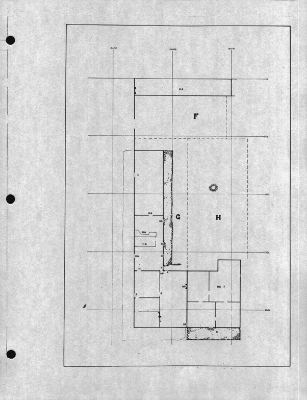
The Courtyard
The courtyard comprised the open area bounded by the
residence and Prévost Addition on the north, the magasins and garden
wall on the east, the stables and the Dugas property on the south with the
Pugnant and the northward extension of the Dugas property defining the westerly
boundary (Fig. 1) [Fig 1 5]. While
no evidence was recovered which permitted any delimitation of garden areas [[Lot
F/G/H Garden - Archaeology: No evidence]], the
two walkways [[Lot
G Pavé
- Archaeology
B-1C-2 ~ Archaeology: 2L8B,C,E,F,H,I; 2L12G,N,T,U; 2L13G,N,U; 2L14G,N,U and Lot
G Flint
Walkway - Archaeology: ?]], several
wells [[Lot F Well - Archaeology: 2L7B,C; Lot H Well - Archaeology: 2L14V; Lot E Well - Archaeology: 2L14W;
Lot H Well
- Archaeology: B-1C-1 ~ Archaeology: 2L13V]], a latrine [[Lot H Latrine - Archaeology: 2L12H]] and a drainage sump or cistern
[[Lot H Latrine/Cistern - Archaeology: 2L12V]] were found
during the excavation [Fig 11] ...
A walkway [[Lot G Pavé - Archaeology B-1C-2 ~ Archaeology: 2L8B,C,E,F,H,I; 2L12G,N,T,U; 2L13G,N,U; 2L14G,N,U]] flanked the west side of the magasins [magasins] and the south wall of the residence (Fig. 30). This walkway was about 9 ft. wide throughout. It was distinguished by a perimeter or curb made of large flat-topped sandstone blocks set into the glacial till subsoil ... The walkway had no paving remaining ... A substantial layer of flint pebbles found a few feet to the west suggested the existence of an additional walkway [[Lot G Flint Walkway - Archaeology: ?]] between it and the nearby cistern [[Lot H Latrine/Cistern - Archaeology: 2L12V]] (Fig. 31) [An extensive, thin layer of flint pebbles found slightly below the modern surface. The presence of a second walkway between the terrace and the nearby cistern was suggested by ... ] ... The flints, not indigenous to the area, were probably imported as ship's ballast and found use here as path dressing ...
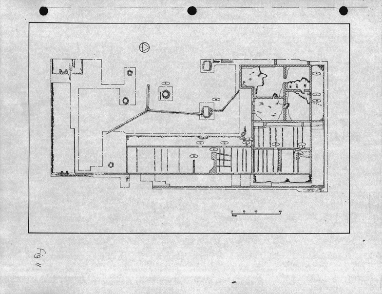
Wells
Four
wells were examined in the courtyard area and all of these in the 1968 season
[Fig. 11]. Two of the wells had been previously excavated, probably by curio
seekers earlier this century. One [One Two] of the previously unexcavated wells was
[were] likely of seasonal utility, a consequence of its [their] slight depth.
Well 1 (2: G14) [2 G14] (fig. 33)
This
well [[Lot F Well - Archaeology: 2L7B,C]] was located 12.00 ft. south of the magasins [magasins] and 4.00 ft.
west of the courtyard wall near the rue St. Louis gateway. Its dimensions were:
top diameter 3.2 ft.; bottom diameter 5.0 ft. and depth below modern surface to
bottom of well ca. 10.3 ft. The well cap had been [had been
was] uncovered some 6 in. below the present day sod. This well was a solidly
built structure representative of the most common type of well construction at
Louisbourg. The well lining consisted of rough fieldstone averaging 1.25 ft. by
1.75 ft. by 0.75 ft., apparently set without the use of mortar. This type of
well generally constricted toward the top, perhaps [perhaps] in
an effort to provide additional structural stability. The well lining was placed
directly upon the hard glacial till without the use of a baseplate. According to
historical sources the well was probably built in 1739 and continued in use at
least until 1745 (Dunn
1969: 50) ...
Well II (2: G12) [2 G12]
This was a very shallow well [[Lot H Well - Archaeology: 2L14V]], probably only useful during relatively wet periods, possibly for watering livestock. It was located 38 ft. [[sic 34.8']] west of the most southerly part of the magasins [magasins] (Fig. 34) Its form was conical with a top diameter of 3.1 ft., and its total depth measured from the modern sod 4.8 ft. The lining of this well was made with waterworn sandstone slabs, some of which were of considerable size, (up to 2.5 ft. by 1.5 ft. by 1 ft.) ... No mortar was used in the construction. The source of the sandstone slabs is not known, although deposits of similar materials occur within 20 miles of Louisbourg. This type of stone was fairly frequently used in other construction in Block 2 and elsewhere within the town. No evidence was found for a superstructure of any kind over the well ... the well was filled with a mixture containing some glacial till. Consequently, the infilling may have occurred about 1754 when large scale transformations of the courtyard were taking place in conjunction with the construction of the Prévost Addition to the residence ...
The nature of the
artifacts does not suggest [point to] any particular period of occupation
[utilization] but it is suggested that [but it is suggested that]
documentary sources indicate a pre-1750 use period (Dunn
1969: 50). [[Dunn did
not identify this well]]
Well III
[This well lies within the property line of Lot E and in my synopsis of that property I have included it as an Event R. E. C may agree or disagree with this, but in any case he should assign well III an event # if he feels it is an element belonging to lot G.]
The second of the diminutive pair of wells [[Lot E Well - Archaeology: 2L14W]], situated some 23 ft. west of well II (Fig. 35) [Well - Archaeology: 2L14V] It measured 2.5 ft. wide at the top and tapered to a pointed bottom at 4.4 ft. below the modern surface. The depth of materials between the well cap and the modern surface was 2.0 ft. Perhaps the only remarkable aspect of this tiny well was a massive boulder jammed form [from] side to side just below the upper edge ... as well as below a second, but smaller boulder at 3.5 ft to 4.2 ft. below the surface datum ... Unless any of the upper part of the cap was demolished this well was certainly very small; little over 2.0 ft. deep. It is difficult to imagine the utility of such a structure, if indeed it was a well ...
[For the moment, this well is considered to be a Lot E rather than a Lot H asset, although Plan 1739-5 suggests that it actually stood on Lot H.]
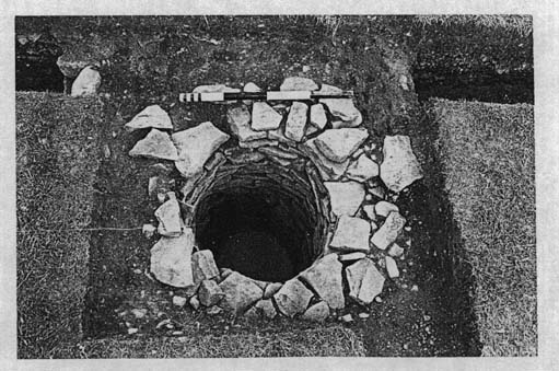
Well IV (2: G11) [2 G11]
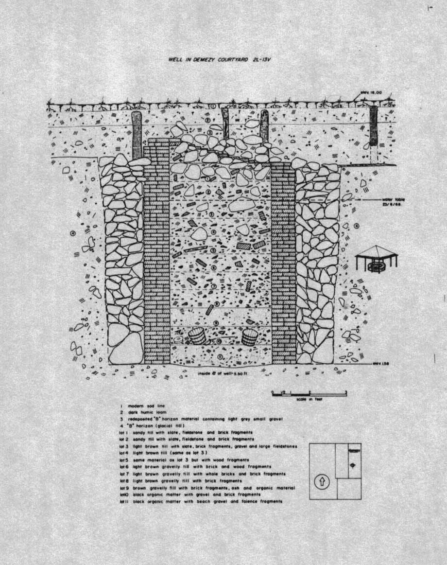
This was the most spectacular well encountered in Block 2. The well [[Lot H Well - Archaeology: B-1C-1 ~ Archaeology: 2L13V]] was centrally placed in the courtyard about 36 ft. west of the magasins [magasins] (Fig. 36) ... This well was cylindrical in section with a consistent internal diameter of 3.10 ft. and spanned a depth of 11.6 ft. from the modern sod to the bottom.
This well was
easily the largest in Block 2 and was further distinguished by having the only
brick lining so far recorded in that area ... The well diameter was constant,
lacking the usual flare toward the bottom encountered in fieldstone masonry
wells at Louisbourg. The construction hole dug for the well was about 9 ft. in
diameter, lined with 1 1.0 fr. fill of loose rubble stone retained by an [an
the] inner liner of unmortared brick. The bricks were rectangular and fairly
uniform, measuring 2 pouces by 4 pouces by 8 pouces, laid
header fashion, aligned with the [with the] radially of [of
with] the well, with a single row of bricks placed behind in stretcher in
contact with the rubble fill. No base was used for the liner; the bricks were
laid directly on the exposed bedrock.
Thw [thw
the] wooden posts which suported a protecting superstructure were found on the
north and south sides of the well top, standing about 8 ft. apart. On [the] two
sides, four upright timbers rested on single foundation beams set about 2.7 ft.
below the 1968 sod line ... While some accumulation of soil deposits is to be
expected over the use period it is likely that the supporting structure was
originally bedded at some depth in the soil. The upper 2.5 ft. of accumulation
is assumed to have been [assumed to have been was] brought from
the digging of the cellars of the West Addition in 1754. As
the well is presumed to have been built around 1749 (Dunn
1969: 50), the
presence of posts still upright in the 1754 debris has to be explained. Two
obvious explanations present themselves: the first, that the posts were buried
in 1754, assuming that the roof structure was removed or thrown down the well,
(ornamental slates were abundant in the upper layers of well fill), the second,
that the well was retained after the adjacent deposit fill in 1754 and that a
new [, higher,] shelter was built over the well. The additional fill would have
been possibly lower than the exposed height of the well capping or perhaps the
capping was raised sufficiently to retain the new fill zone. It is difficult to
favor either interpretation of [of by] the debris alone.
In summary, an
examination of the stratification shows the well was sealed by excavation lot 3,
event [2G] 10 fill. This is the 1753-54 deposit of excavated soil from the
construction of the Prévost Addition. However, the four vertical wooden support
posts of the well superstructure have their upper extant ends covered by the
modern sod and humus zone and are, as well within the level of deposition
following the 1754 fill. From figure 36 37 [figure 36 37]
the soil stratification several stratigraphic interpretations can be mad [Fig.
37]. Firstly, the 1754 deposition was kept from the well interior by the brick
lining. When the well began to collapse several courses of bricks fell into the
interior or were carried away. The layer of 1754 fill would then slump toward
the well interior. As the well house collapsed the slate roofing either fell
into the well or was thrown in. The stratum within the well from lot 3 to 9 is
basically redeposited B-horizon. Throughout these lots are found the roofing
slates and the brick lining materials. As a gradual process of natural leveling
or deliberate infilling [occurred], the lot 3 materials [finally] covered over
the well. It is important to note that this material above the well does not
post-date the well. The fact that it seals the remains of the well indicates
only that the collapse of the well lining permitted adjacent materials to flow
into the resulting void. The soil within the well was nearly free of organic
remains except in the lower three lots (10, 11, 12). It was from these lots that
the vast majority of the ceramic, glass and other artifacts came ..
Eighty-six [complete] bricks were recovered from the well. Part of the original lining, they were only a fraction of a greater quantity ]&] mainly fragmentary [bricks] from the well infilling. All of the complete bricks were measured and the dimensions manipulated to provide mean measurements ands their standard deviations. As follows
Mean length 0.61 ft. SD 0.0213
Mean width 0.31 ft. SD 0.0264
Mean thickness 0.15 ft. SD 0.0331
It is [of] some slight interest to note the greatest standard deviation is observed in the thickness of the brick. It is simply a result of the manufacturing technique utilizing an open topped mould ...
Two hundred and
eighty-two slate fragments were also recovered from the 13V well. The slate
colour is dark grey (Munsel 7.5YR N4/0). Fifty-nine fragments were sufficiently
complete to identify five shapes of slates. They range from 19 to 22 cms. in
length, 6.5 to 6.8 cms. in width, with four exceptions of 13 cms., and are 0.3
to 0.15 [0. 1.5] cms. thick, with four exceptions of 3.7 cms.
The "head" [head] of these slates are squared and show one nailing
hole. Of the fifty-nine identifiable slates 19 [Of the fifty-nine
identifiable slates 19 Nineteen slate] have a round or
"scalloped" butt (Mouchel 1965: 69), eleven a pointed butt while the
remaining three shapes are rectangular (22 specimens), trapezoidal (3
specimens), and wide-rectangular (4 specimens (Fig. 38) (Mouchel 1965:
69) . As illustrated by the various butt shapes discussed above, it may
be seen that slates has [has have] decorative as well as
functional characteristics. The first four shapes are described by Mouchel as
French and are suggested for use in a wet Maritime climate [Mouchel 1965: 69].
The wider rectangular slates could be called English in style due to their
greater thickness and width again according to Mouchel but this condition is
quite unconvincing. There is absolutely no means of determining the source of
these slates available at [at during] this time [time
period] and accordingly it is felt that attempts at defining
"national" styles or origins from a single assemblage are wholly
fallacious. This is the only utilization of slates noted in Block 2 and it is
known that their use was generally restricted to governmental type buildings.
Accordingly, it is odd that the Ordonnateur's well cover qualifies as a Royal
building. Nevertheless, this well, to judge by its large proportions and
extensive use of bricks was, if not grand, then a little out of the ordinary and
so, might have merited a slate covered roof ...
[To conclude] [Since]
there is reasonable [cartographic] evidence that the well was still operating in
1767 (fig. 23] and since the vertical wooden well house support posts are
contained in a post 1754 accumulation, it is quite possible that the well
existed as a functional unit into the period of British occupation in the 1760s
and 70s. The presence of two putatively British buckets cannot really be
accepted as evidence of Anglo [Anglo ?] usage but, since wells were occasionally
cleaned out, then artifact depositions tends to reflect the latter part of any
period of use and abandonment. Hence a suggested deposition period of the last
quarter of the 18th century.
Well V (2G38)
This
well [[Lot G Well - Archaeology: 2L8A]] was situated quite close to the residence at the corner formed by the
meeting of the courtyard sidewalks
[[Lot
G Pavé
- Archaeology:
B-1C-2 ~ Archaeology: 2L8B,C,E,F,H,I; 2L12G,N,T,U; 2L13G,N,U; 2L14G,N,U]]
of the magasins and the residence (Fig. 1)
[Fig. 11] The well was either dug into the curbing of the sidewalks or the
sidewalks built up to the well casing as the curbing butts up against the
exterior of the wall [wall well].
The
diameter of the well increased from 3.0 ft. at the top of [of
to] 3.7 ft. at the bottom and the total depth below the modern surface to the
bottom was 13.53 ft. This well was lined with fieldstone and no mortar was
employed in the masonry. No evidence for a sheltering superstructure was found,
although historical evidence suggested that the well cap was formed with a
wooden framing (Dunn
1969: 50) (Fig 39). These sources suggested that the well was in existence by 1731 and
that it did not appear after 1734 (Dunn
1969: 50) ...
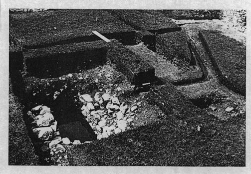
The Cistern or Latrine (2G29)
During
the pre-excavation examination of the site a large [,] open stone-lined pit
[[Lot H Latrine/Cistern - Archaeology: 2L12V]] was
noted in the courtyard area opposite the north magasin (Fig 11). [Fig 11
40]. The pit measured about 4 ft. by 8 ft. near the top of the extant
rubblestone lining (Fig. 31). The floor of the pit, about 5.5 ft. below the
sodline, was bare glacial till without any surfacing. The pit was slightly wider
and longer at the top; presumably the slight flaring added stability to the
unmortared lining (Fig. 68-24) [(Fig. 68-24) In 1968, the
pit was nearly empty ... It is apparent that the feature had been dug out before 1959 as Harper
makes no mention of having made any test explorations in it (Harper 1959: np)
[[Nevertheless, Harper does provide a detailed description of it]]. While it conformed to the general plan of latrines uncovered in Louisbourg,
additional original features become more obvious during subsequent adjacent
excavations. A narrow brick and board-lined trench was traced from the southern
projection of the Prévost Addition to the north side of the cistern (Fig. 40).
A similar wooden drain ran parallel to the magasins from the southwest corner of
these buildings to the south side of the "cistern" ["cistern"
cistern] (Fig. 1). [Fig 11). While it is unknown whether or not water was drawn
directly from the pit, it is evident that the proximity of this feature to the
well [Lot G Well - Archaeology: 2L8A] in the "L" of the residence would [would may]
have helped to maintain a [general] water supply.
The cistern appears on none of the historical plans held at Louisbourg; consequently it is felt that it was constructed at some time after 1750, when documentation for this area decreases. A document of 1750 mentions the construction of a bassin for the courtyard (Dunn 1969: 73b). It is quite likely that the reference is being made to this structure. The drains which lead to the pit need not have been built at the same time. The branch which leads from the Prévost addition was obviously following the erection of that building. The south branch is probably the earliest while that to the west may correspond to the [nearby] latrine (2G13) [[Lot H Latrine - Archaeology: 2L12H]] found at its furthest limit. Could one suggest that water was led to latrines to permit periodic cleaning of these facilities? The slope of the westerly drain suggests a flow away from the cistern toward the latrine.
The Latrine (2G13)
The
latrine [[Lot H Latrine - Archaeology: 2L12H]] was situated 22.7 ft. south of the West [West
Prevost] Addition
on the west property line of the former Rodrigue property (Fig. 1) [Fig. 11].
The lot on which the latrine was built had belonged to the widow Rodrigue until
1741 (Dunn
1969: 22 [[sic:
9]])
[NP]
The fieldstone lining was roughly made with occasional bulges in the side wall
caused by soil displacement. The latrine may have been graced by a course of
reused cut-stone at the top to accommodate a wooden superstructure. One such
reused stone was found at the highest extant point of the walls. The interior
dimensions of the latrine were 4.5 ft. north-south by 7.1 ft. east-west. The
siting of this feature is close to that of a latrine [proposed] to be built with
the proposed [proposed] prisons of 1739 (Dunn
1969: 43) (Fig.
6). It is suggested that the latrine could have [could have]
existed prior to 1754 and that the plans proposed for the prison, (Which were
never carried out), incorporated the latrine in a more elaborately planned form.
The latrine was completely excavated in 1968 ...
The
establishment of a use period for the Bigot [Bigot] latrine can
be obtained through two sources. Historical maps and plans indicate the latrine
existed from 1741 to 1745, the latter date representing New England occupation
... [[The plans in question never directly identify a latrine. The
building until 1742 may be the Rodrigue third house [Lot
H Rodrigue 3rd House - Archaeology: c. 2L9F,G,M,N; 2L12A,B],
with an addition possibly a latrine [Lot
H Latrine - Archaeology: B-1A-4 ~ Archaeology: 2L10F, 2L10G], first shown 1739-5. Later plans until 1745
show a proposed prison and its latrines in the same general location]] Stratographically, the latrine is
sealed by a fill zone which was assigned a date of 1749 - 1770 [Fig. 42[.
Subsequently, it can be assumed the latrine was not in use beyond the initial
date of the fill's deposition.
With these dates for the latrine use, it is evident the artifacts were deposited within it between 1741 and 1745 ...
Fences & Walls [[No evidence except for Lot H/I Fence - Archaeology: Prévost portion of 2L28-29-30Q22/Archaeology: 2L28-29-30Q22 and Lot F Fence - Archaeology: 2L7A-E]]
Many
of the historic plans at our disposition show fences of various types erected in
Block 2. These fences may have enclosed gardens or courtyards either conforming
to the established property alignments or earlier individual pre-alignment
configurations. Archaeology has succeeded in identifying only two of the assumed
fence lines of properties F, G, and H. The first fence [[Lot F Fence -
Archaeology: B-1D-1 ~ Archaeology: 2L7A-E]] uncovered was built along
rue Toulouse [[sic: Rue St. Louis]] from the southeast corner of the south magasin [magasin] (Fig. 1)
[Fig. 11] almost [almost] to the [stables in the] southeast
corner of the block. This masonry courtyard wall was quite substantially built
(over 2 ft. wide) and was erected sometime around 1740. The area appears
undeveloped on a plan of the 1720s and later, in 1739 a wall and fence [[only a
piquet fence is being indicated on Plan 1739-5]] are indicated. It is not
likely that the masonry wall was built then, but rather somewhat later with the
improvements of rue St. Louis in the mid-1740s. Unfortunately, the wall was not
preserved above contemporary ground level thus limiting the retained features to
one doorway (Fig. 42) [42 43] No jamb check or other detail
survived consequently the actual positioning of the gate or door is unknown. The
wall seems to have been incorporated into the Lot F stables or, perhaps the east
stables wall was extended to create the garden wall [The wall seems to
have been incorporated into the Lot F stables or, perhaps the east stables wall
was extended to create the garden wall] As the original 1739 stable was
extended to rue St. Louis by 1741 (Dunn 1969: 44), the erection of the courtyard
wall as an extension of [as an extension of] at or near the
same point in time] the stables wall seems chronologically correct.
None
of the garden fences assumed to have graced the interior of the courtyard were
seen in the various excavations. However, the west property line of Lot H was
marked by a picket fence (Fig. 43) [43 44]
[[Lot
H/I Fence - Archaeology: Prévost portion of 2L28-29-30Q22/ Archaeology:
2L28-29-30Q22]]. It seems that this
fence covered the entire distance from the Destouches [Destouches
Pugnant] house to rue Royalle [[Cox neither found the entire run of the
remains
of the Lot H/I Fence - Archaeology: Prévost portion of 2L28-29-30Q22/
Archaeology: 2L28-29-30Q22]
nor reported upon any of the remains of the Lot E/F Fence: Archaeology: ? -
However, Bruce Council states that there might have been a masonry boundary wall
along the south portion of the E/F property line -
Click
here and go to B 126 89 - 90, November 12, 1975]]
including the small jog
at
its intersection with Lot E. No openings were seen in the course of excavation.
The construction technique was very simple. Trimmed pickets of about 0.6 ft.
diameter coniferous tree trunks were placed upright in a construction trench of
about 1 ft. deep. No evidence for a subsurface nailer or ribband was found and
apparently reinforcement was achieved by ramming stones around the pickets.
Obviously, a ribband would have been provided at some point above the ground
level. The pickets were placed close together at the rate of about two to the
foot. As this property was not incorporated into the Commissaire Ordonnateur's
realm until 1741, its intial [sic] construction must be attributed to Rodrigue
or his neighbours. It is suggested that the fence was not demolished and rebuilt
at any one time but simply repaired where and as needed. This is predicted on
the observation that fill material (2G10) lay up against the east side of the
pickets for some time before the adjacent property to the west was raised to the
same level (Fig. 76). [Fig. 76]. [possibly Figs. 79 & 80
should be inserted to show mid-courtyard stratification.] Whether or not the fence was replaced after this time is impossible to determine from the archaeological record but it might be again assumed that the need for a good enclosure at all times favored repair rather than wholesale replacement. No evidence was found for the fence assumed to have been built between Lots G and H. Presumably, all remains were eliminated at the time of incorporation of Lot H in 1741
(2H48) ...
THE PREVOST [[1754]] ADDITION
...
The extant remains spanned 44.5 ft. on the quay terreplein frontage form [from]
the common walls of the adjacent buildings ... The front [north] wall [of the addition] was on the same alignment as the
residence and consequently advanced upon the Pugnant house by the equivalent [equivalent]
distance of 2.90 ft. The rear [south] wall was also aligned with the rear of the
residence. The west wall of the Addition extended south [[of the common wall ]]
of the Pugnant house some 28.75 ft. A
projection on the south-west corner of the Addition 22.20 ft. wide
extended some 10.50 ft. beyond the 50.00 ft. external depth of the body of the
addition. The historical dimensions [[These are 1739 historical measurements.
There are no known 1754 historical measurements]] were 43 pieds on the
Quay front and 26 pieds deep along the Pugnant common wall plus an
additional 20 pieds of new west wall making a total depth of 46 pieds.
The southwest projection exceeded this depth by about 10 pieds as seen by
the extant ruins ...
The Southwest Room
The largest room in the cellars was the southwest, which was further distinguished by having an 11.4 ft. (measured on the floor) extensions [extension] on the south, 17.5 ft. wide [, out] of a total room width of 25 ft. .... Due to the L-shaped configuration of the room ...
The Pugnant Common Wall
The north of the west wall was formed by incorporating the east end wall of the Pugnant house. The presure of a cellar in the Pugnant house permitted the unaltered inclusion of the wall, as it was unnecessary to extend the masonry downward ...
The South Half of the West Wall
This section of exterior wall ran south 29 ft. to the south wall of the extension of the southwest room ... This was one of the new sections of masonry built in 1754. The wall was built to the same thickness as the Pugnant wall; 2.5 ft. ...
A test trench was dug with a mechanical shovel on the outside of the wall at the southwest corner ...[[Where Harper had found the possible Prévost portion of the Lot H/I Fence - Archaeology: Prévost portion of 2L28-29-30Q22/ Archaeology: 2L28-29-30Q22]]
[[Please click on an image to enlarge it]]
[[Two Image Resolutions]]
|
|
|
| Small | Large |
Figure
1 (135-1-1745)
Site plan showing excavation units
---
 |
 |
 |
 |
[Figure
?]
---
Figure
9 (135-1-1755)
Isometric reconstruction of Prevost Addition including adjacent residence
---
 |
Figure
11 (135-1-1814)
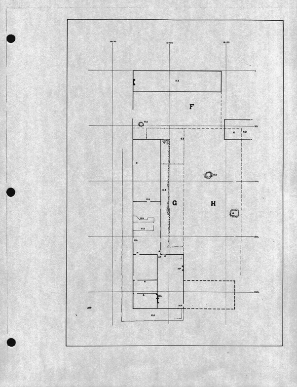
Location plan for some features in lots F, G, and H properties
---
 |
Figure
31 (68-89-6)
Stonelined cistern in Commisaire-Ordonnateurs courtyard
[[Lot H Latrine/Cistern - Archaeology: 2L12V]]
---
 |
Figure
34 (68-379-14)
Overhead view of well to the west of the south magasin
[[Lot H Well - Archaeology: 2L14V]]
---
 |
Figure
36 (68-89-5)
Overhead view of brick lined well in courtyard west of south magasin
[[Lot H Well
- Archaeology: B-1C-1 ~ Archaeology: 2L13V]]
---
 |
Figure
37 (135-1-1759) [G70-326]
Cross section of well stratification and timbers of superstructure
[[Lot H Well
- Archaeology: B-1C-1 ~ Archaeology: 2L13V] - The
timber pattern of the superstructure is based on the "post mould impressions" set upon a
"wooden beam" pattern illustrated on Drawing 2L10A69 (ND-2A and
2L-69-10A), "2L13J adjacent to 2L13V (English well), North View of E/W
Section along 105L"]]
---
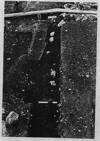 |
Figure
44 (78R008-4)
Picket fence line between lots H and I
[[2L28-29-30Q22 portion of Lot H/I Fence - Archaeology: Prévost portion of
2L28-29-30Q22/ Archaeology:
2L28-29-30Q22]]