LouisbourgProperties Website Design and Content © 2005 by Eric Krause,
Krause House Info-Research Solutions (©
1996)
All Images ©
Parks Canada Unless Otherwise Designated
Report/Rapport © Parks Canada / Parcs Canada
---
Report Assembly/Rapport de l'assemblée © Krause
House
Info-Research Solutions
Researching the Fortress of Louisbourg National Historic Site of Canada
~ Recherche sur la Forteresse-de-Louisbourg Lieu historique national du
Canada
REPORT 2005-62
THE BUILT HISTORY OF BLOCK
THREE, LOTS C, D, AND E
1713 - 1768
THE RÉCOLLET PROPERTIES
BY
ERIC KRAUSE
KRAUSE HOUSE INFO-RESEARCH SOLUTIONS
November 30, 2005
NARRATIVE REPORT
INTERPRETATION
OF EVENTS
SELECT IMAGES SHOWING
CONSTRUCTION PROGRESSION
|
|
|
|
|
|||
| 1718 | 1731 | 1746 | 1767 |
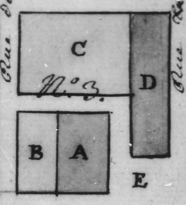
BLOCK THREE
On June 26, 1717, a King's memoir directed Engineer Verville to lay out a town plan for Louisbourg with a quay that measured 60 pieds deep at high tide. As reported on November 10, 1717, the King owned a particular piece of property on that same esplanade that measured 165 pieds fronting the harbour and Block Three, with 36 pieds of depth. The problem - from west to east - was that it was presently occupied by the properties of Jean Baptise LaGrange; the King's bakery; Michel Ballan, Sieur de LaCombe; and the Récollet church. Later, on March 4, 1721, it was declared that all buildings built on the Quay were to be demolished by July, 1722. Further, Verville was to plant masonry posts, of his own design and at King's expense, where each street intersected the Quay, thus defining the northern limit of waterfront properties. Hard on this, on October 7, 1722, Verville submitted a "proposed" town plan. Among other things, town plan 1723-3 suggested a Block Three, Lot E configuration, one that, by means of a fence, carved a most unusual waterfront setback out of Lot E and Rue St. Louis. While this design may have satisfied the need for a place publique of the size as decreed on May 31, 1723, the final town plan of October 24, 1734, was no doubt the more practical of the two.
The 1734 plan described a Block Three that measured 165 pieds along the Quay with 198 pieds of depth. By now LaGrange had moved to Lot A of Block Three and the Récollets to Lot C. Lot D was reserved for a parish church, and Lot E for a public place. Although the King's brevet of [1717 - See also Map 1717-2] had predetermined the dimensions of Lot C, the same brevet had provided property dimensions for Lot D and Lot E that exceeded the amount remaining. As a result, Lot E was re-configured in or before 1734 to occupy an area to the side of Lot D to ensure that Lot D kept its original brevet size. As a result, where in 1720, to the west of Lot A there existed a Rue De L'Eglise, in 1734, there now existed but a place [publique], though it would prove to be one in name only.
THE EARLY YEARS
From 1713 until February 19, 1717 (when Engineer Verville surveyed the Lot C and D area for a Récollet parish church, cloister and garden), it was the surgeon LaGrange, who held effective and locally approved - though non-conceded - control over Lots C, D, and E, and who during this period would build three harbour-facing piquet buildings (LaGrange 1 [House/Hospital (1713-1717)], LaGrange II (Storehouse (1713-c. 1723/1724)]) and LaGrange III [House/Hospital/LaChaume Residence (1714-1723/1724)] both on and fronting a newly surveyed area, first shown on Map 1717-2, and later known as Lot E. In October, 1717, the authorities demolished and burnt the LaGrange I structure - apparently it stood on Lot E - but, in stark contrast, left the other two, which stood further north, both out of lot alignment and in the quay. These would remain in LaGrange hands, to the chagrin of the authorities, both at Louisbourg and in France, until he later shifted (albeit slowly) over to Block Three, Lot A following his August, 1720 concession to that property.
The LaGrange and Récollet stories are well documented, and but for the built-histories that were relevant to an understanding of Lots C, D, and E, they are not repeated in this narrative. Rather that more complete built-history has been abstracted in the Select Interpretative Summaries chapter. In that same chapter too will be found an additional link if the complete report has been digitally transcribed and published to the Louisbourg Institute of Cape Breton University Web Site.
________________________
The results of Verville's February 19, 1717 survey appeared on the c. October 1717-2 map where the traced dimensions of the proposed Lot D church property appeared for the first time, as well as areas which later became Lots C and E. In his February 19 letter, Verville noted, with clarity, that not only did LaGrange own [though not through a concession] the surveyed property lots, but also that he should be compensated for their loss according to a July 17, 1715 Toisé (by Engineer DeCougane) and February 18, 1717 estimation (by Engineer L'Hermitte).
As noted, Map 1717-2 did not show LaGrange I but it did illustrate two existing buildings to the north of the Block Three butte or plateau: LaGrange II (the larger structure to the east) and LaGrange III (the smaller structure to the west) that stood fully outside the area and on the quay. These, at various times (e.g. issuances of May 22, 1717 or May 2, 1722) - being on the Quay, not on conceded property, or out of block alignment - were susceptible to immediate demolition or removal should the local officials ever wish to enforce said regulations.
On August 23, 1720, the day following his official concession to Lot A, LaGrange III was already perceived as unfit for service: The roof - half-gone - leaked rain throughout, and all its exterior supporting wall braces, wall sleepers, interior doors, most hardware, ground and first storey flooring, one harbour-side window sash, and all but one of its piquet partitions had been removed. Now being only a matter of time until LaGrange II and III would be demolished, it was on October 27, 1722, that LaGrange added to the compensation mix a developed property also lost to quay and Block Three church requirements. This was most likely the large garden/yard described on July 17, 1715 and which was probably then located to the south of LaGrange 1. Finally, by c. 1723/1724, the LaGrange buildings in the area fronting the Récollet and reserved properties were removed.
THE RÉCOLLET YEARS
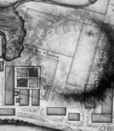
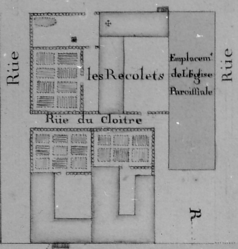
As early as 1716, and no doubt by February 19, 1717, Engineer Verville had physically laid out a property for a Récollet of the Province of Brittany church, cloister, and a garden on the "Butte" [des habitations], which property was clearly owned by LaGrange. On November 1, 1717, the local authorities approved a plot plan (Map 1717-8) for the Récollets that met the requirements of Louisbourg's first attempt at an official town plan as called for by, among others, the King in his memoir of June 26, 1717. Property development foresaw a church, convent, yard and garden, from west to east on Lots D and C. Accordingly, the Lot C plot plan was decreed on June 21, 1718 with letters patent of November 20, 1718, officially delivering the lot to the monks. Subsequently, in the 1720's, they would build their convent on the lot, but, to the west, on Lot D, property reserved for a parish church, this construction never materialized. To the north, in front of the proposed church, Lot E, designated as a place publique, sometimes referred to as the place de l'église, this area stood during the French period without development as well. The Rue du Cloître, as reserved - presumably public, land - ran east and west and served to separate Lots A and B to the north from Lot C to the south. Rue De L'Eglise, which would have run north and south, between Lot A and E, was identified by name only in its formative years and, unlike Rue du Cloître, not all in the final official town plan of October 24, 1734.
From February 19, 1717 until at least 1723/1724, the Récollets were not active on Lots C, D, and E and during that time they were holding their "divine service" in their church, which stood partially out of lot alignment on Lot B, Block Three. However, even prior to 1723, the tavern keeper Beauséjour had already unofficially come into possession of the Lot B property (perhaps even having built a small building there next to the church), and this arrangement was made official on June 1, 1724. Following that, by c. 1725-1726, a large L-shaped Beauséjour building appeared on Lot B.
On December 7, 1721, it was declared that Engineer Verville had excavated and laid a portion of the foundations for both the Lot C presbyter and Lot D church since his return to the colony that year. Construction on the Lot D church had begun on October 23, 1721, though as early as July 1, 1721, the King's storekeeper may have already supplied lime for the project. However, on November 24, 1721, it was claimed that DeMesy had looted the stones from the church property. Shortly thereafter, as reported on December 7, 1721, buried in the same excavated work would be two medals, a bronze and a silver, like others similarly placed to date [and thus like the 1720 commemorative medal found in October, 1923, that bore the profile of Louis XV on one side and a conjectural view of Louisbourg on the other].
By October 7, 1722, the construction of the presbytery may have resumed (See also Map 1722-1), with that portion of the L-shaped structure facing Rue Royale begun or completed during 1723. On February 19, 1724, its bell (Marie Josephe) of the chapel (Sainte-Claire) was blessed and perhaps as early as April 12, 1724, the first general service was held in a chapel now serving both the Récollet and Louisbourg's civilian populations. Reflecting the building's importance from that date on, public notices would also have been posted, from time to time, on the main entry door. Until, that is, beginning c. September 19, 1735, when the garrison chapel of the King's Bastion Barracks assumed the civilian role until the final fall of Louisbourg in 1758.
According to Map 1722-1, which provided written measurements, and which mirrored closely, +/- several pieds, the approved property dimensions of the official October 24, 1734 town plan (Map 1734-5), the monks residence measured 66 pieds along Rue Royalle beginning at the Lot C/Lot D boundary line, and 84 pieds of depth to Rue du Cloître, with a lot to the east measuring 56 pieds along Rue Royalle to Rue De L'Etang (thus totalling 122 pieds along Rue Royalle). Because Lot D for the proposed church to the west remained at 42 pieds along Rue Royalle, thus preserving the [1717] brevet and the Map 1717-2 allocation, the monks had in fact lost 10 pieds along Rue Royalle that had been mentioned in their 1717 brevet, described in their February 19, 1717 survey (Map 1717-8: 132 pieds), and conceded on June 27, 1718.
On October 24, 1734, gaining one pied back, the Monks were awarded a confirmed concession for Lot C of 123 pieds along Rue Royalle that again preserved the 42 pieds reserved for the parish church. However, Map 1734-4 clearly illustrates an obvious problem here. While the monks had built (see Map 1722-1) their L-shaped convent in the 1720's to where the western boundary limit had been set in 1718, Engineer Verrier, on plan 1734-4, clearly illustrates an enlarged Lot D property along Rue Royalle which incorporated a western portion of a built convent. Indeed, when, on April 16, 1737, asked to prepare a plan and devis for the construction of a parish church on Lot D, Verrier obliged in 1738 with Map ND-32. Although the proposal was immediately rejected that very year, the dimensions of the church (52 pieds x 138 pieds) did show, however, that its planned width would have impinged upon Lot C by 10 pieds!
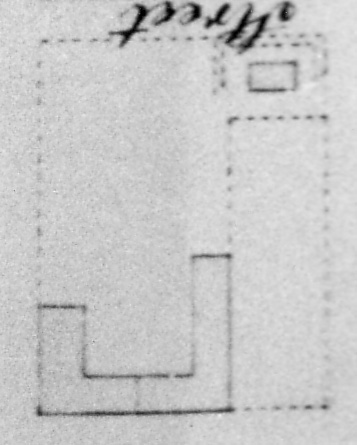
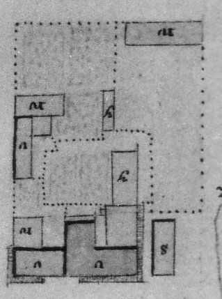
Most pre-1745 plans site an L-shaped presbytery resting on conceded property Lot C whereas early post-1745 plans illustrate only a more or less rectangular building either at or near its western boundary, or, more likely, on Lot D, that did not appear on Map 1752-11 at all anywhere. Perhaps most of the Lot C portion was either destroyed during the 1745 siege or, by July 8, 1746, partially torn down during the subsequent English occupation for use as fuel, as was the case with many other buildings. What is known for certain during this latter period is the following: On June 20, 1752, the monk's residence was completely dilapidated, but yet on the night of July 9-10, 1758, being a place where gun powder was being stored in two rooms, it was hit and ignited by siege fire, but survived.
Perhaps here Maps 1767-1A and 1768-1 hold the key. The only development illustrated for Lot C on Map 1752-11 is a Rue du Cloître yard in the north-west corner of the lot. Here, in this area, in 1767 stood an occupied "Stores and Stables" while to the east, had been built two attached houses, perhaps replacing the dilapidated Monk's residence of 1752, of which one had been built across the Rue De L'Etang terminus of Rue du Cloître, with the rest of Lot C being a garden. In 1768, of the three structures, only the terminus house [now called a private French wooden storehouse] appeared on that plan.
Taking then everything into consideration:
Just prior to 1745:
(1) The complex was an L-shaped wooden structure
(2) The Rue Royalle portion of the ell stood taller than the interior ell of Lot C (1731-3; 1734-4)
(3) A chapel existed at the eastern section of the Rue Royalle portion
(4) A raised entrance upon Rue Royalle existed at the Lot C/Lot D boundary line
(5) There was a yard at the corner of Rue Royalle and Rue De L'Etang with its usual amenities
(6) There was a garden at the corner of Rue de L'Etang and Rue du Cloître with its usual amenities
Streets:
(1) Rue du Cloître existed to the south of Lot C but, without a parish church on Lot D, there was no active Rue De L'Eglise or Place De L'Eglise (Lot E)
Post-1745:
(1) Perhaps a western Rue Royalle portion of the original wooden ell functioned as the monk's residence until declared completely dilapidated by June 20, 1752
(2) Most of Lot C was a garden
(3) At some point it was decided to close off the eastern portion of Rue du Cloître where it intersected at Rue De L'Etang
(4) To the east, on a portion of, and to the west near Rue du Cloître, a cluster of wooden outbuildings were built, apparently after 1752 and prior to 1758, of which one was perhaps the monk's new residence
________________________
As already noted, Lot D and Lot E saw little development, with perhaps the failure to raise a parish church on Lot D being the most surprising given the catholic nature of the colony. But being reserved land - and, as reported in 1739, on a plateau that would need to be lowered should construction ever happen - perhaps inevitable were several excavations that occurred there: On October 30, 1744 it was reported that rocks were taken from the parish butte, while on December 31, 1750, it was earth from Lot D required to level Rue l'Etang, from the intersection of Rue de France down to the Quay which included that portion opposite Block Three, Lots C and B. However, the "Old [wooden] Shed." at the corner of Rue Royalle and Rue St. Louis - perhaps even straddling Lot C and Lot D - that appeared in a August 10, 1768 inventory is certainly less explainable, and may have first appeared in 1745 and 1746, on assorted English plans, as a smaller structure, set back from, or on, Rue Royalle, either near, or at, the corner of Rue St. Louis, either entirely on Lot D or straddling Lot C and Lot D. However, since it did not appear on Map 1752-11, it may not have been a significant feature.
As for Lot E, as a public place it ought not be confused with the place publique most oft mentioned at Louisbourg. That place, "vis-ŕ-vis Langevin" (Place du Port), serving, in fact, as a place de la marine, existed as early as October 26, 1716 and perhaps as late as July 13, 1757, and was where a pillory (carcan) was raised - possibly temporarily - as early as November 15, 1725, and permanently on August 23, 1733 in the Place du Port area. No doubt, the Lot E place would have had a greater role if the Lot D church had been constructed, perhaps even resulting in the raising of a carcan, as Sabatier, the controller of the marine, had proposed in November, 1729, for punishing those committing civilian offences. However, like the carcan designated in the same memoir for near Block One, for those stealing from the King, both suggestions went unheeded. Notwithstanding its apparent unimportance, the lack of an associated Lot D Parish Church, and even the existence of a dilapidated Lot C monk's convent, its memory lived as "place publique prčs de la paroisse" as late as 1752 (Map 1752-11).
On January 19, 1729, Marie Magdelaine Noel, was buried on the Lot D proposed church location, in the middle of the nave on the gospel-side [north side[ of the alter, much reminiscent of five burials beneath the flooring of the garrison chapel of the King's Bastion Barracks. There four known individuals had their heads pointing away from said alter while the single unknown burial, that of a child, was placed "roughly" parallel to the alter. On August 12 and October 9, 1732, first Pčres Ignace Audren - next to an iron cross - and then Narcisse Varin were likewise interred on the proposed church site.
Finally, at least by April, 1766, a goodly-sized "Quay Guard house" had been set upon on Lot E, at the corner of the Quay and [Rue De L'Eglise].
BUILDING DETAILS
(All measurements are written dimensions [i.e. not scaled])
(A) LAGRANGE OCCUPATIONAL PERIOD
(I) LAGRANGE 1 HOUSE/HOSPITAL (1713-1717)
First Observation: Constructed 1713
Owner: Jean Baptiste Martin LaGrange, surgeon/merchant
Location: Probably on Lot E
Function:
(1) Hospital (winter 1713-1714)
(2) Residence (1713-1717)
Dimensions: 36/37 pieds long by 20 pieds wide
Construction Details:
(1) Walls: Vertical piquets
(2) Floor: Wooden resting on squared-off piquet sleepers
(3) Fireplace
(4) Oven
(5) Roof: Bark
Garden: Attached, large, and perhaps centered to the south upon the property
Outbuildings: N/A
Value: Building - 700 livres (February 18, 1717/October 27, 1722)
Property Chronology: 1715 - 1721
Last Observation: Demolished by October, 1717, and the debris burned in the ovens of the bakery
(II) LAGRANGE 11 STOREHOUSE (1713-c. 1723/1724)
First Observation: Constructed 1713
Owner: Jean Baptiste Martin LaGrange, surgeon/merchant
Location: Fronting Lot E (on the Quay), facing the harbour, with LaGrange I to the south and LaGrange III to the west
Function: Storehouse
Dimensions: 40 pieds long by 20 pieds wide
Construction Details:
(1) Walls: Vertical piquets resting on piquet sleepers
(2) Roof: Bark
Garden: To the south of the building
Outbuildings: N/A
Value:
(1) Building and land clearance - 500 livres (February 18, 1717/October 27, 1722) where the piquets cost 25 livres per 100, the joists or beams cost 5 livres each, and labourers and food 40 sols per day for clearing the land and building the structure
(2) Garden/Yard: 1500 livres (October 27, 1722)
Property Chronology: 1715 - 1721
Last Observation: Removed by c. 1723/1724.
(III) LAGRANGE III HOUSE/HOSPITAL/LACHAUME RESIDENCE (1714-1723/1724)
First Observation: Constructed 1714
Owner: King
Tenants:
(1) Jean Baptiste Martin LaGrange, surgeon/merchant (1714-1715, c. 1717 to 1720 -1723/1724)
(2) Louis LaChaume (1715-1720)
(3) King's Employees (1717-1722)
Location: Fronting Lot E (on the Quay), facing the harbour, with LaGrange II to the east
Function:
(1) Small house (1714-1723/1724)
(2) Hospital (1715)
Dimensions: 27 pieds long x 18 pieds wide or 30 pieds long x 20 pieds
Construction Details:
(1) Walls: Vertical piquets resting on large piquet sleepers and supported by exterior piquet struts
(2) Floors:
(a) Ground Floor: Piquet resting on piquet sleepers
(b) First Floor: Flooring material
(3) Partitions: Vertical piquets (small)
(4) Doors:
(a) Exterior: Lockable (nailed lock and bolt)
(b) Interior: Double-Leaf
(5) Windows (glazed sashes):
(a) One facing the harbour
(b) One facing the land
(c) Had hardware
(6) Window Panes: One window had at least 7 panes
(7) Fireplaces
(8) Roof:
(a) Initially bark
(b) Earth [sod] placed, perhaps over wooden slabs
(9) Use of nails
Garden: N/A
Outbuildings: N/A
Value: Building
(1) 250 livres (October 19, 1715)
(2) 1000 livres (October 27, 1722)
Property Chronology: 1715 - 1721
Last Observation: By October 27, 1722, the building was out of service, and was removed by c. 1723/1724.
_________________
(B) RÉCOLLET OCCUPATIONAL PERIOD
(I) LOT C PRESBYTERY
First Observation:
(1) 1721
Owner: Récollets of the Province of Brittany
Location: Lot C
Function: Presbytery/hospice/convent/cloister
Dimensions:
(1) L-Shaped prior to 1745
(a) Rue Royalle: 66 pieds
(b) Interior: 84 pieds
(2) Ell gone after 1745, with perhaps only a small Rue Royalle rectangular portion remaining
Construction Details:
(1) The excavation and laying of stones for a portion of the foundations began 1721
(2) Construction resumed perhaps by October 7, 1722
(3) 66 pieds along Rue Royalle beginning at the Lot C/Lot D boundary line, and 84 pieds of depth to Rue du Cloître (1722)
(4) Construction of that portion facing Rue Royale begun or completed during 1723
(5) The 30 livre bell (Marie Josephe) of the Chapel (Sainte-Marie) blessed on February 19, 1724
(6) A lot to the east measuring 57 pieds along Rue Royalle to Rue De L'Etang (1734)
(7) Plan 1734-4 perhaps an accurate representation
(8) Completely dilapidated by June 20, 1752
Garden: Plan 1734-4 perhaps an accurate representation
Yard: Plan 1734-4 perhaps an accurate representation
Outbuildings:
(1) On July 9-10, 1758, at least two rooms were ignited by siege fire, but extinguished
(2) A cluster of wooden outbuildings were built c. 1749-1758, one of which was probably the monk's residence
(a) Two private French wooden rectangular storehouses (or houses), built across Rue du Cloîture, fronting Rue De L'Etang
(b) One house with its gable end facing Rue De L'Etang
(c) One interior stables
Value: N/A
Property Chronology: 1717 - 1738
Last Observation: 1768
(II) LOT D CHURCH
First Observation: Under construction October 23, 1721
Owner: Reserved
Location: Lot D
Function: Church (proposed)
(1) Burial: Marie Magdelaine Noel (January 19, 1729, towards the middle of the nave on the gospel-side [north side] of the alter)
(2) Burial: Pčres Ignace Audren (August 12, 1732, next to an iron cross)
(3) Burial: Narcisse Varin (October 9, 1732)
(4) Plan 1734-4 perhaps an accurate representation
Dimensions: N/A
Construction Details:
(1) The excavation and laying of stones for a portion of the foundations began October 23, 1721
(2) Some stones removed c. November 24, 1721, from the church property, and in the excavation there were placed a bronze and a silver medal, each bearing the profile of Louis XV on one side and a conjectural view of Louisbourg
Garden: N/A
Outbuildings: An old wooden rectangular shed, fronting Rue Royalle (August 10, 1768) of unknown use
Value: N/A
Property Chronology: 1717 - 1738
Last Observation: 1768
(III) LOT E PLACE PUBLIQUE
First Observation: May 31, 1723
Owner: Reserved
Location: Lot E
Function: Public Place
Dimensions:
(1) N/A
(2) Plan 1734-4 perhaps an accurate representation
Construction Details: N/A
Garden: N/A
Outbuildings: Guardhouse (constructed c. 1758-1767)
(1) Wooden (August 10, 1768)
(2) Much out of repair by August 10, 1768
(3) At least one masonry chimney (May 30, 1765)
Value: N/A
Property Chronology: 1717 - 1738
Last Observation: 1768
(IV) RUE DU CLOITRE
First Observation:
(1) Not by Name: 1717
(2) By Name: 1718
Owner: Reserved
Location: North of Lot C
Function: Street
Dimensions: N/A
Construction Details: N/A
Garden: N/A
Outbuildings: N/A
Value: N/A
Property Chronology: 1717 - 1738
Last Observation: 1767
(V) RUE DE L'EGLISE
First Observation:
(1) Not by Name: 1717
(2) By Name: August 22, 1720
Owner: [Reserved]
Location: West of Lot A
Function: Street
Dimensions: N/A
Construction Details: N/A
Garden: N/A
Outbuildings: N/A
Value: N/A
Property Chronology: 1717 - 1738
Last Observation:
(1) Absorbed by Lot E by October 15, 1734
(2) Re-appeared in 1767
PROPERTY DETAILS
(All measurements are noted [i.e. not scaled])
Note: Fence type and locations, and gate openings, are always problematic and conflicting, particularly when illustrated on cartographic sources. One can and should always assume the existence of perimeter as well as interior and garden fences, whether illustrated or not. In addition, the following plans should make for some interesting discussion: 1731-3, 1746-5, 1751-8, and 1767-1A.
(I) July 17, 1715: Survey of non-conceded King's Property (Fronting and including Block Three, Lots A, C, D, and E) which LaGrange has developed:
(1) 60 pieds at the front
(2) 160 pieds deep in the middle because of the garden, bounded to the west by Genier (Block 2, Lot G), and to the east by the cemetery
(3) 250 pieds deep
(II) November 10, 1717: Non-conceded King's Property (Fronting Block Three, Lots A, C, D, and E)
(1) 36 pieds deep
(2) 165 pieds fronting the harbour, bounded to the west by Genier (Block 2, Lot G), and to the east by De Pensens (located east of the Block Three, Lot B church, LaCombe, and bakery buildings and fronting Block 4, Lot C)
(II) December 23, 1717: Non-conceded King's Property (Fronting Block Three, Lots A, C, D, and E)
(1) 36 pieds deep
(2) 165 pieds fronting the harbour, bounded to the west by Genier (Block 2, Lot G), and to the east by De Pensens (located east of the Block Three, Lot B church, LaCombe, and bakery buildings and fronting Block 4, Lot C)
(III) June 22, 1718: Non-conceded King's Property (Fronting Block Three, Lots A, C, D, and E)
(1) 36 pieds deep
(2) 165 pieds fronting the harbour, bounded to the west by Genier (Block 2, Lot G), and to the east by non-confirmed property
(IV) June 15, 1721: Non-conceded King's Property (Fronting Block Three, Lots A, C, D, and E)
(1)165 pieds fronting the harbour, bounded to the west by Genier (Block 2, Lot G), and to the east by De Pensens, next to the Block 2, Lot B church [Note: Although LaGrange had received his concession on August 22, 1720, this fact is ignored here. The reason is clear when one examines Plan 1721-2, dated September 12, 1721. Whereas the projected church (Lot D) and presbytery (Lot C) were within the aligned Block Three, the King's property frontage (165 pieds fronting Lots A, C and D) existed to the north of the Block within the area designated for the Quay.]
(V) September 12, 1721: Non-conceded King's Property (Fronting Block Three, Lots A, C, D, and E)
(1)165 pieds fronting the harbour, bounded to the west by Genier (Block 2, Lot G), and to the east by De Pensens
_________________
(1) By February 19, 1717 (Survey)
(1) Lots C, D, and E
(II) Map 1717-2 (Map Measurements)
(1) Lot D
(a) Rue St. Louis: 126 pieds
(b) Rue Royalle: 42 pieds
(b) Lot E: 42 pieds
(2) Rue du Cloître
(a) Lot A and Lot B: 90 pieds
(3) Rue de l'Etang
(a) Lot A: 60 pieds
(III) November 1, 1717 (Approved Measurements) - Map 1717-8
(1) Lot C
(a) Rue Royalle: 132 pieds
(b) Rue de L'Etang: 60 pieds [78 pieds]
(2) Lot D
(a) Rue Royalle: 42 pieds
(b) Rue de L'Etang: 126 pieds
(3) Street Measurements
(a) Rue Royalle: 174 pieds
(III) June 27, 1718 (Concession)
(1) Lot C
(a) Rue Royale: N/A
(b) Rue De l'Etang: N/A
(c) Rue De Cloître: N/A
(d) Lot D: N/A
(IV) August 22, 1720 (Lot A Concession)
(1) Street Measurements
(a) Rue De L'Eglise: 96 pieds along Lot A
(b) Rue de Cloître: 56 pieds along Lot A
(V) October 7, 1722 (Map 1722-1: Map Measurements)
(1) Block Measurements:
(a) Rue Royalle: 164 pieds
(b) Rue St. Louis: 199 pieds
(1) Lot C:
(a) Rue Royale: 122 pieds
(b) Rue De l'Etang: 84 pieds
(2) Lot D:
(a) Rue Royale: 42 pieds
(b) Rue De l'Etang: 144 pieds
(3) Lot E:
(a) Along Lot A: 102 pieds
(4) Rue du Cloître:
(a) Along Lot A and Lot B: 98 pieds
(5) Rue de l'Etang:
(a) Width: 24 pieds
(VI) May 31, 1723
(1) Lot E: 15 toise [90 pieds]
(VII) October 24, 1734
(1) Block Three
(a) Rue Rue Royalle: 165 pieds
(b) Quay: 165 pieds
(b) Rue St. Louis: 198 pieds
(d) Rue de L'Etang: 198 pieds
(2) Lot C (Concession) - 9963 square pieds
(a) Rue Royalle: 123 pieds
(b) Rue De L'Etang: 81 pieds
(c) Rue du Cloître: N/A
(d) Lot D: N/A
(3) Lot D and Lot E Place (Land reservation) - 11241 square pieds
(a) Quay: 67 pieds
(b) Lot A (105 pieds) and Width of Rue du Cloître (12 pieds): 117 pieds
(c) Rue St. Louis: 198 pieds
(d) Lot C to the East: 81 pieds
(e) Rue Royalle: 42 pieds
(f) Rue du Cloître Width: 12 pieds
(g) [Rue de L'Eglise] Width: 25 pieds
(4) Lot E Place (Land reservation)
(a) Located to the side, and included in the Lot D land reservation since the lot required for Lot D did not allow for the original planned disposition
(b) Lot A: 105 pieds
(5) Rue du Cloître (Occupation) - 1176 square pieds
(a) Width: 12 pieds
(b) Lot A and Lot B: 98 pieds
(VIII) 1737-1738 [MAP ND-32]
(1) Lot D (Construction proposal)
(a) Width: Not less than 52 pieds
(b) Length: Not less than 138 pieds