Bigotyard
Website Design and Content © December 14, 2001, by
Eric Krause, Krause House Info-Research Solutions
(© 1996)
All Images © Parks Canada Except
Where Noted Otherwise
Researching the
Fortress of Louisbourg National Historic Site of Canada
Recherche sur la Forteresse-de-Louisbourg Lieu historique national du Canada
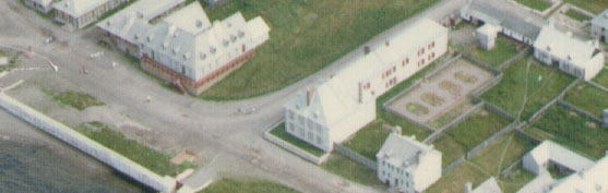
Fortress of Louisbourg, Block Two,
Lots F/G/H Properties:
Landscape Arrangements as of 1744
REPORTS
BACK
Chronological Index ~ Annotated Extracts from Historical and Archaeological
Reports of the Fortress of Louisbourg, 1959 - Present
Note: [...] represent Krause Annotations
Memo By Doug Ross-Shafir
Structural
Design Team Minutes
B 314
May 19, 1995
Block Two Garden Fence
1995/96
RECAP FENCES
Archaeology EARP Screening
...
Block 2 Bigot Garden Fence
[D] ...
Test trenches were dug in the yard
with most of the features such as the four wells , latrine, catch basin and drain and interior terrace excavated
(Harris 1982:206). No fences were recovered archaeologically in the area of the present period
fencelines. In the centre of the yard
(2L13J) near the 1749 brick
well the remains of piquets were found. Archaeological drawings 2L10A69 &
2L10B69 indicate two sizes of piquets. The larger piquets were 6 - 6 1/2 inches in diameter and were set 2 1/2 feet in the ground
with blunt ends. The larger piquets were spaced from 6 feet to 7 feet apart. Between these latter posts were smaller 4 3/4 inch diameter posts set 1 1/2 feet into the ground.
There also appears to have been a buried riband 3 3/4 inches thick. The basic plan appears to be similar to the reconstructed period
fence ...
[ Note: The Ross-Shafir research memo clearly contradicts, without comment, the findings of Richard E. Cox, who, in his report, Archaeological Excavations on the Properties of the Commissaire Ordonnateur, Block Two, Louisbourg, 1968-1978, Unpublished Report AE 44 (Fortress of Louisbourg, [1979]) unequivocally stated that no interior fences were located on this property. Although he did discover the "post mould impressions" that Ross-Shafir would much later interpret as for a fence line with a buried ribbon, for him they were the remains of the uprights, set upon a wooden beam, required of a superstructure built upon this brick well [Lot H Well - Archaeology: B-1C-1 ~ Archaeology: 2L13V]. Figure 37 (135-1-1759) [G70-326], Cross section of well stratification and timbers of superstructure.
Located eight feet apart upon the well top - one row on the north and one row on the south side of the well, four posts to a side - these upright appear on the two Cox drawings of two separate sections which Ross-Shafir had referenced: 2L10A69 (ND-2A and 2L-69-10A), "2L13J adjacent to 2L13V (English well), North View of E/W Section along 105L" and 2L10B69 (ND-2-B and 2L-69-10B), "South view of E/W Section of 2L13J adjacent to 2L13V (English well) ( along 95L)". In the Cox report, Figure 37 faithfully reproduce the pattern illustrated on drawing 2L10A69.
In summary, the two drawings are of parallel post moulds set eight feet apart to the south and north of the well in question. They do not represent a garden fence as described by Ross-Shafir.]