Bigotyard
Website Design and Content © December 14, 2001, by
Eric Krause, Krause House Info-Research Solutions
(© 1996)
All Images © Parks Canada Except
Where Noted Otherwise
Researching the
Fortress of Louisbourg National Historic Site of Canada
Recherche sur la Forteresse-de-Louisbourg Lieu historique national du Canada
Fortress of Louisbourg, Block Two,
Lots F/G/H Properties:
Landscape Arrangements as of 1744
REPORTS
BACK
Chronological
Index ~ Annotated Extracts from Historical and Archaeological Reports of the Fortress of
Louisbourg, 1959 - Present
Note: [...] represent Krause Annotations
J. Russell Harper, A report of preliminary archaeological investigations carried out in the summer of 1959 under contract with the Department of Northern Affairs and National Resources, Unpublished Report AE 01 (Historic Sites Division, 1959) - Extracts
[72]
AREA
"B"
Town Block bounded by Rue Royale,
Rue St. Louis, Le Quay and Rue
Toulouse
[74]
AREA 1
"PALACE" OF THE ORDONNATEUR
OR INTENDANT ...
[75]
[Please click on an image to enlarge it]
 |
Figure 35:
"Palace" of the Ordonnateur or Intendant
---
[82]
AREA B-1A
WESTERLY EXTENSION TO THE "PALACE"
BUILT TO CONTAIN COUNCIL CHAMBERS
AND POSSIBLY THE GOAL
[92]
...
Test B-1A-4:
Excavation was made to locate the south-westerly corner of the westerly extension of
the Palace" ...
Exterior stone masonry walls with the corner of the building were located ...
Exterior:
An
unlined pit [Lot
H Latrine - Archaeology:
B-1A-4 ~ Archaeology: 2L10F, 2L10G] measuring
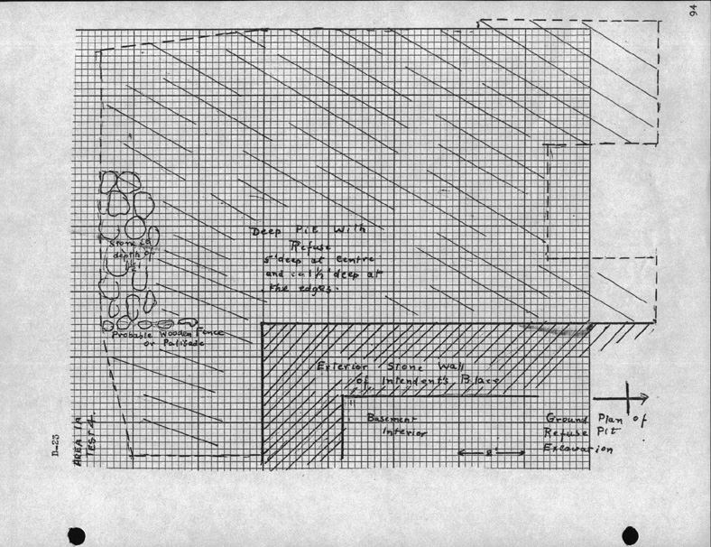
about 12' x 15' (Fig. 44D) and up to 5' deep is located to the west of the
corner of the building. It appears to
have been a kind of refuse pit for garbage from the building ...
A line of stones at a depth of 1 1/2' extends southerly from the south westerly corner of the building
... This marks the easterly edge of the refuse pit. They seem to mark the
location of a wooden fence [Lot H/I Fence - Archaeology: Possible Prévost
portion
of
the Lot H/I Fence - Archaeology: Prévost portion of 2L28-29-30Q22/ Archaeology:
2L28-29-30Q22], probably of a palisade type, which seems to be intended for the westerly edge of the
"Palace" property (as seen in Samuel Clough's sketchbook) ...
[94]
Figure
44d -
Area 1A - Test 4 [South West Corner of the Prévost Addition]
"Probable Wooden Fence or Palisade"
|
|
[To
the east: Prévost stone wall |
[103]
AREA
B-1B
ORIGINAL "PALACE" AREA - RESTORED WALLS
[107]
AREA
B - 1D
NORTH-WEST RESTORED ROOM OF THE "PALLACE"[sic]
Test B-1D-1
Surface indications showed some structure built into the floor in the south-west corner of the room. This was excavated and found to be a stone-lined pit [Lot G/H Latrines - Archaeology: B-1B-1-5 ~ Lot G/H Latrines - Archaeology: 2L4E] measuring 4'3" x 9' x 2'3" deep (Fig. 49 A-C). In the north-west corner of the pit an opening in the northerly wall 1'11" wide had a brick vaulted arched roof leading out of the pit. This opening led to a soft passage, evidently open during the French period ...
[117]
AREA B -
1C
COURTYARD TO THE REAR OF THE
MAIN "PALACE" BUILDING
...
Test B-1C-2:
Excavation was made to the west of the centre of the southerly wing of the "Palace" where a loosely laid stone walk [Lot G Pavé - Archaeology B-1C-2 ~ Archaeology: 2L12T-2L12U - (Portion of Lot G Pavé - Archaeology B-1C-2 ~ Archaeology: 2L8B,C,E,F,H,I; 2L12G,N,T,U; 2L13G,N,U; 2L14G,N,U)] was uncovered. This would seem to have extended out into the courtyard to a width of 7' from the building wall, and to have been edged on its westerly margin with carefully placed stones as a sort of retaining wall ...
Well:
The De Mezy house plan [ND 7 and ND 7A] shows a well [Lot H Latrine/Cistern - Archaeology: 2L12V] in the courtyard. Most Louisbourg wells are indicated by two concentric circles but this is more elaborately designated with a square structure marked. A depression was excavated at the point indicated a few years ago and a stone pit measuring 4' x 7' was excavated to a depth of 6'. The stonework is in a crumbling condition. No artifacts were found. The pit seems to be remains of the well [Lot H Well - Archaeology: B-1C-1 ~ Archaeology: 2L13V] indicated, and a well is shown in the Clough sketch at this point (Fig. 54E) ...[Note: Inexplicably, Harper illustrated this well on Figure 35 in a position closer to the central well [Lot H Well - Archaeology: B-1C-1 ~ Archaeology: 2L13V] than to the DeMezy cistern [Lot H Latrine/Cistern - Archaeology: 2L12V]. Consequently, his excavation has been sited as being at the central well location.]
[121]
AREA B-1D
REAR OF "PALACE" BLDG
A 2' wide stone masonry wall base [Lot F Fence - Archaeology: B-1D-1 ~ Archaeology: 2L7A-E] is readily traceable along the westerly margin of Rue St. Louis extending south from the south-east corner of the "Palace".
Test B-1D-1 [B-1D-1]
Excavation showed the stone wall ... Wall remains only survive for about 6" above the original ground level ... In the southerly part of of the test excavation there is the remains of a pit loosely filled with stones, brick and other debris. This is evidently a well [Lot F Well - Archaeology: B-1D-1 ~ Archaeology: 2L7B,C] shown on certain of the French plans. Excavation of the well was commenced but water almost to the surface made it impractical with the time available.