Bigotyard
Website Design and Content © December 14, 2001, by
Eric Krause, Krause House Info-Research Solutions
(© 1996)
All Images © Parks Canada Except
Where Noted Otherwise
Researching the
Fortress of Louisbourg National Historic Site of Canada
Recherche sur la Forteresse-de-Louisbourg Lieu historique national du Canada
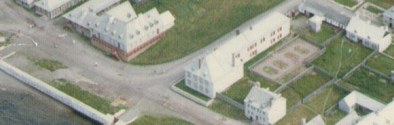
Fortress of Louisbourg, Block Two,
Lots F/G/H Properties:
Landscape Arrangements as of 1744
REPORTS
BACK
Chronological Index ~ Annotated Extracts from Historical and Archaeological
Reports of the Fortress of Louisbourg, 1959 - Present
Note: [...] represent Krause Annotations
Richard E. Cox, Preliminary Report De Mezy House, Unpublished Report AE 14 (Fortress of Louisbourg, June 26, 1969) - Extracts
INTENDANT'S BUILDING
...
[2]
The "latrine/lavatory" [Lot G/H Latrines - Archaeology: B-1B-1-5 ~ Lot G/H Latrines - Archaeology: 2L4E] was built about 1722 and incorporated into the residence by the widening of the building in 1736 (Merchant Block 2, Sept.1968). [Merchant (later Dunn) never referred to this 1722 date in her two later Block 2 reports] This facility had ceased functioning before the lowering of the quay terreplein in 1742; it consisted of a large square pit, stone-lined, [3] measuring 4.25' by 8.50' by 2.50' deep. In the northeast corner of the pit is a brick-arched drain exit, 1.5' wide and a maximum of 2.0' high. A drain of these dimensions runs through the north wall and has been truncated at its farthest north point by the removal of material during the 1742 quay terreplein construction ...
The "latrine/lavatory" [Lot G/H Latrines - Archaeology: B-1B-1-5 ~ Lot G/H Latrines - Archaeology: 2L4E] and drain were excavated by Harper in 1959 ...
[16]
The open area, or courtyard, which is partially enclosed by the Intendant's buildings can be broken into these following areas: the 7.90' wide pavé [Lot G Pavé - Archaeology B-1C-2 ~ Archaeology: 2L8B,C,E,F,H,I; 2L12G,N,T,U; 2L13G,N,U; 2L14G,N,U] which flanks the North and South Magasins; the area to the south of the South Magasin, bounded by the stables the gardens [Lot F/G/H Garden - Archaeology: No evidence] and walk area between the pavé [Lot G Pavé - Archaeology B-1C-2 ~ Archaeology: 2L8B,C,E,F,H,I; 2L12G,N,T,U; 2L13G,N,U; 2L14G,N,U] and the west property line [2L28-29-30Q22 portion of Lot H/I Fence - Archaeology: Prévost portion of 2L28-29-30Q22/ Archaeology: 2L28-29-30Q22]. This last area held the latrine [Lot H Latrine - Archaeology: 2L12H], sump [Lot H Latrine/Cistern - Archaeology: 2L12V], 3 wells [Lot G Well - Archaeology: 2L8A; Well - Lot G Archaeology: 2L14V; Lot H Well - Archaeology: B-1C-1 ~ Archaeology: 2L13V] and the dovecote [Lot F Dovecote - Archaeology: No evidence]. The dovecote has not been found. It may be presumed that it was built entirely of wood and was not preserved. One well [Lot G Well - Archaeology: 2L8A], which is near the angle formed by the North Magasin and the West room, was excavated by Harper in 1959, as was the sump/latrine [Lot H Latrine/Cistern - Archaeology: 2L12V], which is situated some 34.0' south west of the well [Lot G Well - Archaeology: 2L8A]. The sump is connected by a shallow brick and stone lined drain to the S.E. corner of the jog in the 1754 addition. The latrine [Lot H Latrine - Archaeology: 2L12H] was built 22.7' south of the Westerly [Prévost] addition on the west property line [Lot H/I Fence - Archaeology: Prévost portion of 2L28-29-30Q22/ Archaeology: 2L28-29-30Q22] ...
[17]
A further feature which appears either to be a very small well [Lot H Well - Archaeology: 2L14V] or latrine is situated 34.8' west of the South Magasin. It was constructed of water-worn brown sandstone slabs. Although the few contents of this feature include only French artifacts, it is conceivable that it was built in the 19th or the early 20th Century.
About 28' north of this last structure there is a large well [Lot H Well - Archaeology: B-1C-1 ~ Archaeology: 2L13V] which is in effect double lined. There is an outer layer of large field stones which are held in place by three rows of brick. The bricks are set with their ends facing inward and are sporadically mortared. The well was originally covered with a wooden superstructure of which six posts were located, 3 on the north side and 3 on the south. The vertical posts rested at regular intervals on 2 well preserved sleeper beams. From these it may be deduced that the shed covering was open to its east and west ends. Quantities of small finely made roofing slates were found in the upper levels of the well. Quite likely, these covered the well roof at one time. The material which fills the upper levels of the well would appear to date the well prior to 1754. It would not be too rash to suggest that the well was built during the occupation of 1745-1748 ...
[18]
South west of this structure is a diminutive well [Lot E Well - Archaeology: 2L14W] built very much like the other small slabstone wells to the east. It was effectively closed by two large stones ... The well is less than 6 feet deep.
[For the moment, this well is considered to be a Lot E rather than a Lot H asset, although Plan 1739-5 suggests that it actually stood on Lot H.]
A relatively thick stratum of flint-gravels [Lot G Flint Walkway - Archaeology: ?] lies along the courtyard pavé [Lot G Pavé - Archaeology B-1C-2 ~ Archaeology: 2L8B,C,E,F,H,I; 2L12G,N,T,U; 2L13G,N,U; 2L14G,N,U] and separated from it by 18.5' [Note: Cox says in his later 1968-1978 report: "A substantial layer of flint pebbles found a few feet to the west ..." Harris then says in 1982: "One other feature which may be related to this cistern or catch basin was a flint walkway which seems to have led out from the terrace toward the catch basin." If this is accurate, then this measurement is 18 1/2 inches (18.5")] ...
Original topography of this area is quite different from that of today. The construction in 1722 truncated the small hill upon which the Intendant's building stood. The material from this truncation was used to partially fill a boggy area which stretched from Block 16 into the westerly part of Block 2. A section cut along an east-west line through the [assumed] garden [Lot F/G/H Garden - Archaeology: No evidence] immediately south of the latrine [Lot H Latrine - Archaeology: 2L12H] gave a fairly clear picture of the chronology of this area. The west end of the trench revealed the preserved soils of a poorly drained zone or marsh margin, whereas in the east the section revealed the truncation of the "B" horizon in the vicinity of the North Magasin. The material which directly overlies the marsh is 2.0' thick and tapers to nothing near the sump/latrine [Lot H Latrine/Cistern - Archaeology: 2L12V] 32.0' west of the magasin. The upper few inches of this stratum clearly mark the level of the [assumed] 1720s and later garden ...