Search
Website Design and Content © by Eric Krause,
Krause House Info-Research Solutions (© 1996)
All Images © Parks Canada Except
Where Noted Otherwise
Report/Rapport © Parks Canada / Parcs Canada
---
Report Assembly/Rapport de l'assemblée © Krause
House
Info-Research Solutions
Researching the
Fortress of Louisbourg National Historic Site of Canada
Recherche sur la Forteresse-de-Louisbourg Lieu historique national du Canada
Louisbourg Stamp - 1995
By Eric Krause (Krause House Info-Research Solutions)
February, 2004
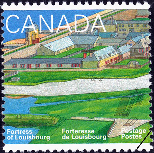
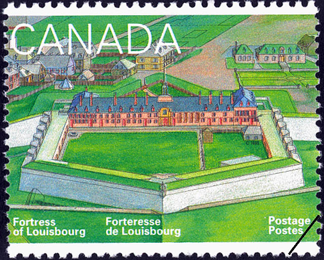
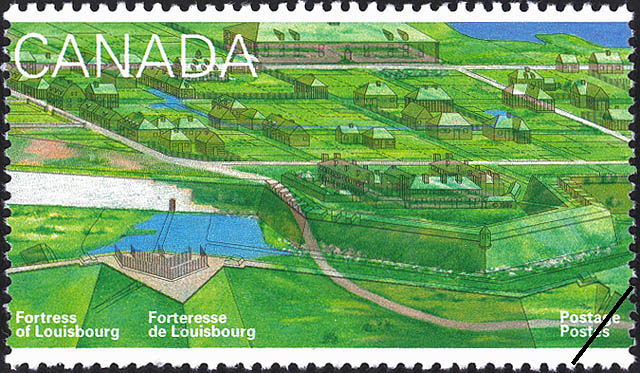
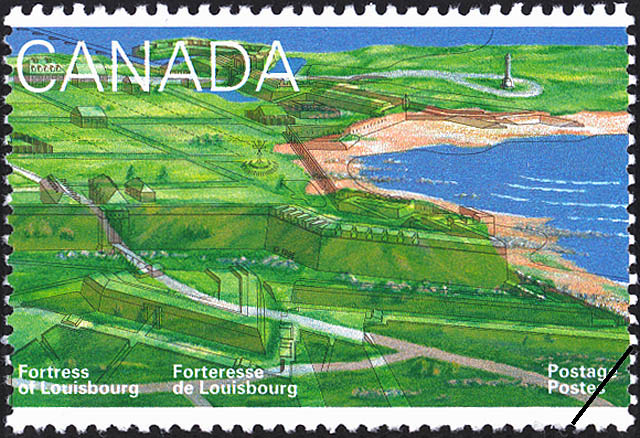
On May 5, 1995, Canada Post Corporation issued a series of five stamps honouring the Fortress of Louisbourg. Designed by Rolf Harder [other Canada Post employees involved: Bill Danard and Wayne Defour, Visual Designer], and researched and checked for historical accuracy by several key staff members of the Fortress of Louisbourg, these stamps recall a portion of the remarkable history of the Fortress of Louisbourg:
"IN A LAND of largely English loyalties, the port of Louisbourg, on the eastern coast of Cape Breton Island, provided France with a powerful fortress to protect her commerce and fisheries. 1995 marks the 275th anniversary of the official founding of that fortress, and the 250th anniversary of its siege by the New Englanders. European fishermen had been reaping the wealth of these Atlantic waters since well before the 16th century. Cabot's 1497 voyage to this area brought reports of cod so abundant they could be scooped up in baskets without hook, line, and bait! With England in possession of much of the eastern coast of North America, France felt it necessary to build a fortified naval station. In 1720 Louisbourg was founded, close to the fishing grounds, close to France, and strategically close to the St. Lawrence River, and New France. With massive fortifications and walls of 20 feet thick and 30 feet high, Louisbourg was one of the strongest fortresses on the Atlantic coast of America. Inside the walls, wide, straight streets fashioned after French cities, and impressive town gates gave it an air of European permanence. Louisbourg quickly became a busy and thriving seaport. For the English colonists to the south, however, Louisbourg posed a serious threat to their interests, and when France declared war on Great Britain in 1744, the New Englanders were alarmed. They launched an army to attack the fortress, and in 1745 their sailing fleets landed outside the walls. After a siege of 49 days the French garrison capitulated. Despite the high casualties suffered by the New Englanders in their victory, after three years the British returned Louisbourg to the French. Nine years later, however, the British and French resumed hostilites, and a similar siege and capture of Louisbourg took place. Determined that the town never again fall into French hands, the British decided to demolish the fortifications. By 1760, the destruction was complete, and this romantic French port was reduced to heaps of stone. In 1960 the Fortress of Louisbourg was declared a National Historic Site, and reconstruction was begun. While only 20% of this rare archeological site has been rebuilt, the reconstructed buildings and finely crafted gates give us a unique understanding of a protected enclave of 18th century French life. The five stamps create a modern panorama of historic Louisbourg. Three stamps show the reconstructed Fortress, and two portray the unreconstructed portion of the site, with transparent line work giving shape to the multi-layered treasure chest that was once Louisbourg. The stamps were issued on May 5, 1995." [Text and Image © CRB Foundation Heritage]
At Louisbourg, the historian assigned to the project was Eric Krause, Historical Records Supervisor, who undertook a study of the buildings and landscape features that once existed within the town and on Rochefort Point that were not within the current reconstructed zone. His colleagues, Bruce Fry, archaeologist , checked the fortification features, while Yvon LeBlanc, Restoration Architect, ensured the historical accuracy of all the illustrated architectural features.
 |
|
|
|
|
 |
|
 |
|
 |
|
"This year is of special significance for both the Fortress and Town of Louisbourg. It marks the 275th anniversary of the official founding of the fortress; the 250th anniversary of the siege by the New Englanders; the 100th anniversary of the commemoration by the Society of Colonial Wars; and the 100th anniversary of the arrival of the Sydney and Louisbourg (S & L) Railway. The French did not regard Louisbourg only as a fortress. It existed as a centre of military and commercial activity. Louisbourg had great offensive strength when a powerful fleet was stationed within its harbour. The Bretons had established a fishing station on the island (named after them) by the early 1500s but had no thoughts of colonization. When a group of Scots did in 1629, the French razed their fort. Under the 1713 Treaty of Utrecht, France lost claims to Newfoundland and mainland Nova Scotia, but retained Isle Royal (Cape Breton). With England in possession of most of the eastern coast, France felt the need to construct a fortified naval station to protect her commerce and fisheries and maintain links into the St. Lawrence. About 160 persons arrived at Louisbourg in September 1713; many were relocated fishermen from Placentia Nfld. Some construction took place between 1713 and 1719, but major fortifications are usually dated as beginning in 1720. The site was not a commanding one, but it had both landward and seaward defences as well as harbour defence positions. Covering some 57 acres, Louisbourg was one of the strongest fortress on the Atlantic coast. It was also one of the busiest seaports on the continent after Boston, New York and Philadelphia. By 1744, the population was nearly 3,000 and in the 1750s the garrison increased to 3,500. For the New Englanders, Louisbourg was both a place of beneficial commerce and a serious threat to their interests. In May of 1744 Louisbourg learned that France and Britain were at war. New Englanders, alarmed by French attacks on mainland Nova Scotia, sailed for Louisbourg in 90 transports. Rather than launching a frontal assault, small parties were landed to the southwest. By nightfall 2,000 invading troops were ashore and within seven weeks, the New Englanders were within the walls of the fortress. Casualties were higher among the victors, and this was compounded when England delayed sending replacement troops and the weary and ill-equipped New Englanders were forced to spend the winter in Louisbourg. Despite the price of victory, the British gave Louisbourg back to France three years later. In 1749, French troops returned and the British garrison sailed for Halifax. During the Seven Years War, a very similar siege and capture took place. Under the command of British officers, the town was reduced to ruins, with few French guns remaining in action before the final surrender. The people were evacuated, and the British demolished the fortifications in 1760. The 1763 Treaty of Paris ceded Cape Breton to the British. Within 11 years, there were more British than French settlers in Louisbourg; by 1818, only 13 families dwelled there. For 100 years, Louisbourg has been linked with Sydney, Nova Scotia as a vital partner in the shipping of coal. When Sydney's harbour froze over in winter, Louisbourg's ice-free harbour provided the alternative. The existing narrow gauge railway line was replaced by a standard gauge line between Sydney and Louisbourg in 1895. Around 1767, Captain Samuel Holland, Surveyor General, erected a monument of cut stones at Louisbourg, in what may have been the first such commemoration in Canada. An 1895 ceremony focused attention on the site, and in 1928 the old town and much of the battlefield were declared a National Historic Site. In 1940, the status was raised when it became the Fortress of Louisbourg National Historic Park." [Text © Canada Post Corporation" - Canada Post Corporation. Canada's Stamps Details, Vol 4, No. 3, 1995, p. 19-21. Source: POSTAL 1476]
![© CRB Foundation Heritage]](images/StampLsbg_Panorama.gif)