Retour ŕ la page premičre
Search
Website Design and Content © by Eric Krause,
Krause House Info-Research Solutions (© 1996)
All Images © Parks Canada Except
Where Noted Otherwise
Report/Rapport © Parks Canada / Parcs Canada
---
Report Assembly/Rapport de l'assemblée © Krause
House
Info-Research Solutions
Researching the
Fortress of Louisbourg National Historic Site of Canada
Recherche sur la Forteresse-de-Louisbourg Lieu historique national du Canada
NORTH SHORE PROPERTIES
BY
ERIC KRAUSE-
Krause House Info Research Solutions
2002 - Present
ARCHEOLOGY ON THE NORTH SHORE
![]() Return to the First Page/
Return to the First Page/
Retour ŕ la page premičre
Archaeological
Coastal Survey
at the Fortress of Louisbourg NHS
©Parks Canada/Parcs Canada
R. Duggan
August 28, 2002
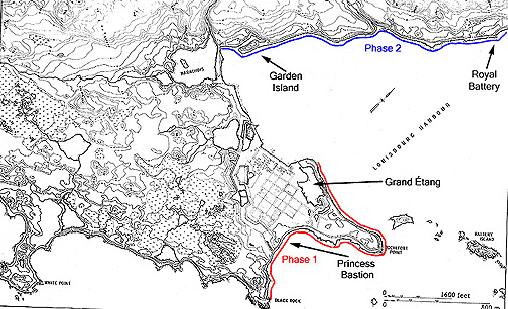
At least once a year, Louisbourg archaeologists carry out a coastal survey at the Fortress of Louisbourg NHS. The walking survey is carried out in two phases. Phase 1 extends along the coastline around Rochefort Point and Phase 2 extends along the north shore of Louisbourg harbour (figure 1). The purpose of the survey is to identify cultural features exposed along the eroding shoreline banks. These surveys are an integral part of the cultural management process at Louisbourg.
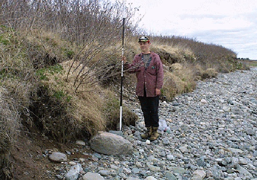
Archaeological coastal surveillance is undertaken regularly because of the high level of erosion along the coastline. Coastal regression, resulting from sea level rise and wave erosion (especially during storms) may be very subtle or readily visible (figure 2). A location that appears to be stable one year may become quite unstable in the next.
Although the historic site includes a 31 km stretch of coastline, the archaeology coastal survey focuses on the Rochefort Point & North Shore Harbour areas because these locations bear the highest probability of containing 18th century cultural resources.
During occupation of the fortress, numerous fishing & domestic establishments and military works lined the coast & harbour. Now, after two hundred & fifty years of erosion, a number of these structural features are becoming exposed along the shoreline. Actually, this exposure has been occurring for several decades, but the problem has been intensifying over the past ten years or so, as the coastline regresses farther inland. Each coastal exposure of 18th century cultural activity represents loss of historical knowledge & integrity.
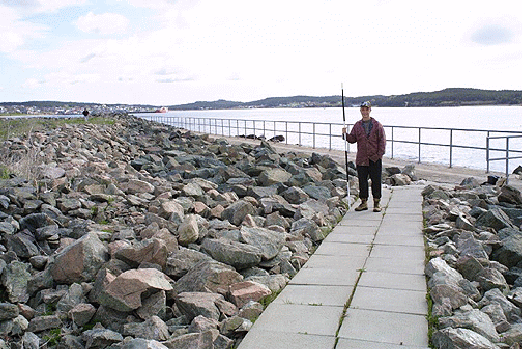
Although it may not be possible to halt the effects of erosion, we are able to rescue cultural data through archaeological salvage efforts, and in some cases we are able to protect the eroding resources with sea wall barriers, such as the large stone & concrete barrier at the Royal Battery located on the north shore of the harbour (figure 3).
In the past, archaeological coastal surveys revealed several significant sites that have required extensive archaeological rescue excavation. Typically, exposure of cultural materials along the shoreline prompts preliminary archaeological testing and historical research of the area. The results of these studies are then used to assess the nature & extent of the threatened cultural resource. This assessment then guides archaeological rescue efforts or the establishment of erosion barriers.
It is important to understand that all cultural materials found exposed along the Louisbourg shoreline are property of the site and must not be removed from their environmental context prior to visual assessment by a Louisbourg archaeologist.
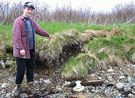
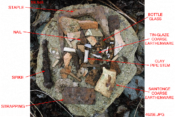
Presently, there are small exposures of cultural material along the coastline that are in need of preliminary assessment. For example, a small yet dense exposure of artifacts & fieldstones have recently become exposed in an eroding bank (figures 4+5). The artifacts include:
- 40 Saintonge ‘ring & dot slip decorated’ & ‘speckled’ green-glazed coarse earthenware plate sherds
- 15 tin-glazed coarse earthenware sherds
- 11 clay pipe stem fragments (bore diameter = 5/64)
- 3 fragments of light olive green bottle glass
- 1 fragment of blue-green glass
- 6 hand-wrought iron nails, a spike, a staple & strapping
- oyster shell
- mortar
This assemblage is suggestive of French domestic activity in the first half of the 18th century. Given that the exposure lies on the North Shore in the vicinity of known 18th century French occupation, it is tentatively suggested that this feature exposure may be part of a much larger domestic site. Further archaeological testing of the location will confirm or refute this hypothesis and historical study may also reveal an association between the feature location and a documented 18th century property.
In addition to small coastal exposures of cultural materials, there are several large scale exposures of cultural features at the fortress, such as the Princess Bastion. The sea has been encroaching on the Princess Bastion for decades and effort has been made in the past to protect it with armour-stone barriers, but the barriers have not held & the bastion continues to suffer. We are in the process of developing a new barrier to protect this feature, but until then, archaeological surveillance of the bastion continues on a regular basis.
Obviously erosion problems at Louisbourg are not going away. Sea level will keep rising and storms will happen again and again. However, routine archaeological surveillance of the coastline will continue to be an effective way of identifying and anticipating cultural resource loss.
Please Click on an image to enlarge it
 |
 |
|
 |
 |
 |