Search
Website Design and Content © by Eric Krause,
Krause House Info-Research Solutions (© 1996)
All Images © Parks Canada Except
Where Noted Otherwise
Report/Rapport © Eric Krause ---
Report Assembly/Rapport de l'assemblée © Krause
House
Info-Research Solutions
Researching the
Fortress of Louisbourg National Historic Site of Canada
Recherche sur la Forteresse-de-Louisbourg Lieu historique national du Canada
Louisbourg Maps and Plans (17th-18th-Century Publications)
Not Available in the Archives of the Fortress of Louisbourg
By Eric
Krause,
Krause House Info-Research Solutions, 2004 - Present
Note:
The listing of the maps and plans in the Fortress of Louisbourg Archives
is contained in a Fortmaps Database.
If you wish to go there, first bookmark this
address and click ../DBTextWorksResearchFortress/default.htm
THESE ARE MOSTLY LOW RESOLUTION MAPS AND PLANS
CLICK HERE FOR HIGHER RESOLUTION MAPS AND PLANS
|
THE EIGHTEENTH CENTURY |
|
|
1700 |
|
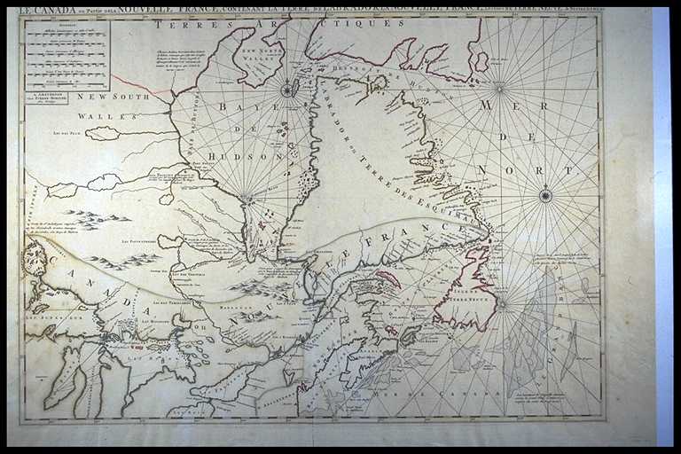 |
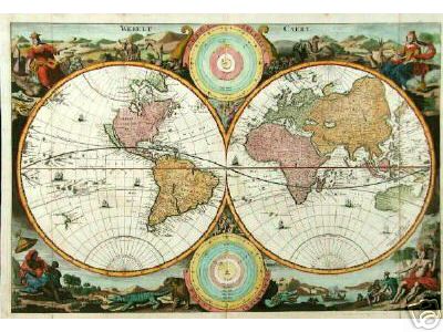
Pierre Mortier, LE CANADA ou Partie DE LA NOUVELLE FRANCE, CONTENANT LA TERRE DE LABRADOR LA NOUVELLE FRANCE, Les Isles DE TERRE NEUVE, de NOSTRE DAME &c: A AMSTERDAM Chez PIERRE MORTIER. Avec Privilege. Pierre Mortier (1661-1711), published circa 1700 [© McMaster University Library, Research Collections, Accession # 102883] |
|
1703 |
|
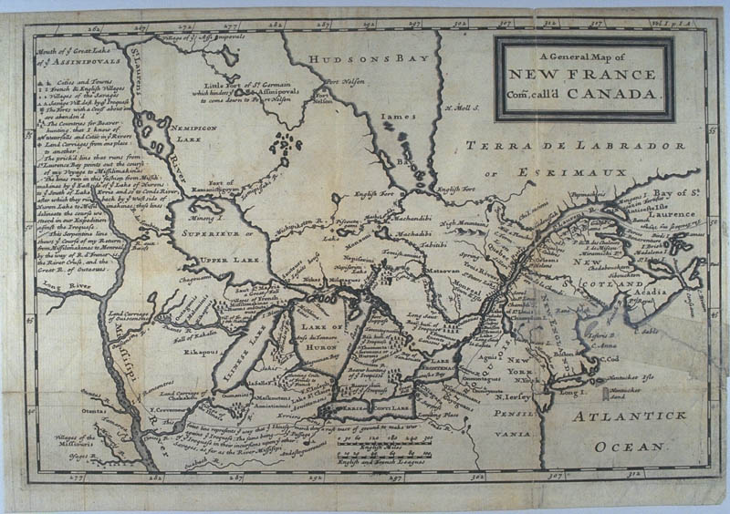 |
Louis Armand Lahontan, Baron de., A General Map of NEW FRANCE Com, call'd CANADA. Vol. I. p. I. A. Published 1703 and 1735. Originally published in Lahontan's New Voyages to North America, published 1703 & 1735. "This map was published in 1703 and 1735 without change." [© McMaster University Library, Research Collections, Accession # 107317] |
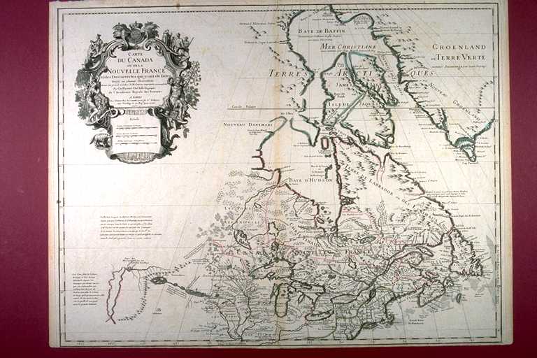 |
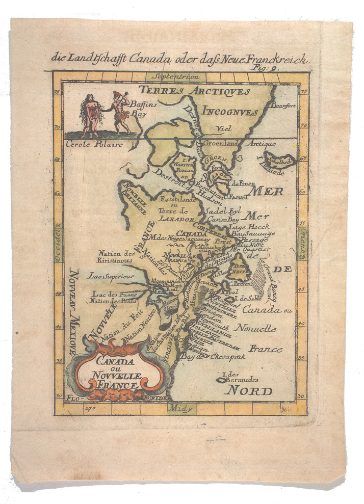
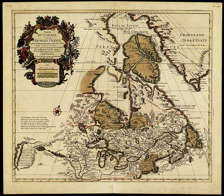
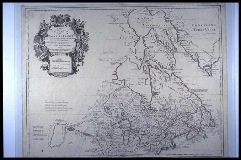
Guillaume de l'Isle, CARTE /DU CANADA OU DE LA NOUVELLE FRANCE / et des Decouvertes qui y ont été faites Dressée sur plusieurs Observations et sur un grand nombre de Relations imprimées ou manuscrites Par Guillaume Del'Isle Geographe de l'Academie Royale des Sciences A PARIS Chez l'Auteur Rue des Canettes prez de St. Sulpice. avec privilege de sa Majte. pour 20. ans 1703. Published 1703 [© McMaster University Library, Research Collections - Accession # 107034] |
|
1704 |
|
 |
Visscher - Stpppendaal- 1704 |
|
1708 |
|
 |
Guillaume de L'Isle, Carte du Canada ou de la Nouvelle France et des decouvertes qui y ont été faites : dressée sur plusieurs observations et sur un grand nombre de relations imprimées ou manuscrites. Paris : Chez l'auteur, [1708]. [© McGill University, 72 dpi - G3400 1708 L5 RBD Map] |
|
1712 |
|
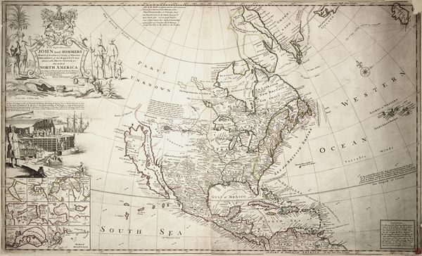 |
Herman Moll, John Lord Sommers This map of North America Herman Moll Geogr. Published: London [c. 1712] |
|
1713 |
|
 |
Pieter van der Aa. Canada, ou Nouvelle France : suivant les nouvelles observations de Mess'rs. de l'Academie Royale des Sciences, etc. augmentées de Nouveau. Leiden : Chez Pierre vander Aa, [1713]. [© McGill University, 72 dpi - G3400 1713 A2 RBD Map] |
|
1714 |
|
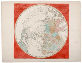 |
Guillaume Delisle, HEMISPHERE SEPTENTRIONAL LES TERRES ARCTIQUES... Paris, France, 1715 |
|
1715 |
|
| Herman Moll, A view of ye general and coasting trade-winds, monsoons or ye shifting trade winds through ye world, variations &c. According to the newest and most exact observations, by H. Moll geographer. Published: c. 1715 | |
|
1719 |
|
 |
Henri Abraham Châtelain. Carte du Canada ou de la Nouvelle France & des découvertes qui y ont été faites, dressée sur les observations les plus nouvelles, & sur divers mémoires tant manuscrits qu'imprimez. [Amsterdam : Chez Châtelain, 1719]. [© McGill University, 72 dpi - G3400 1719 C5 RBD Map] |
 |
Allain Manesson-Mallet. Canada ou Nouvelle France. [Frankfurt : J. A. Jung, 1719]. [© McGill University, 72 dpi - G3400 1719 M34 RBD Map] |
|
|
1730 |
|
|
Homann Heirs, "Totius Americae Septentrionalis et Meridionalis Novissima Representatio, Quam ex Singulis Recentium Geographorum Tabulis Collecta Luci Publicae Accomodavit." 1730 |
|
|
Guillaume de L'Isle. Carte du Canada ou de la Nouvelle France et des decouvertes qui y ont été faites : dressée sur plusieurs observations et sur un grand nombre de relations imprimées ou manuscrites. Chez Jean Covens et Corneille Mortier, [1730]. [© McGill University, 72 dpi - G3400 1730 L4 RBD Map] |
 |
Mattheus Seutter, "Accurata delineatio celeberrimae Regionis Ludovicianae vel Gallice Louisiane ol. Cauad et Floridae adpellatione in Septemtrionali America". 1730 |
|
1732 |
|
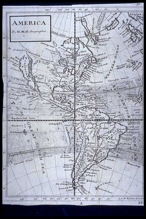 |
Herman Moll, America. By H. Moll Geographer. (Printed and sold by T. Bowles next ye Chapter House in St. Pauls Church yard, & I. Bowles at ye Black Horse in Cornhill, c. 1736) [© McMaster University Library, Research Collections - Accession # 3932] |
|
1733 |
|
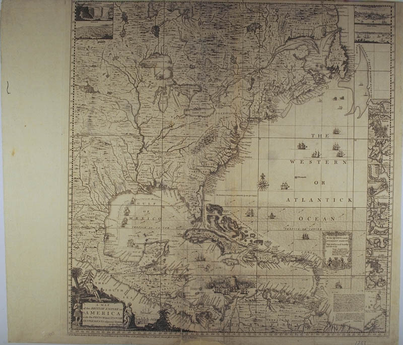 |
Henry Popple, A MAP / of the BRITISH EMPIRE in AMERICA with the FRENCH and SPANISH SETTLEMENTS adjacent thereto by Hen. Popple. Sold at Stephen Austen's Book Seller in Newgate Street & by Thos. Willdey at the great Toy Shop in St. Pauls Church Yard London. Price 2 Shillings. W.H. Toms Sculp. AMERICA SEPTENTRIONALIS [text on top of sheet cut off] To the QUEEN'S most EXCELLENT MAJESTY This MAP is most humbly Inscribed by Your MAJESTY'S most Dutiful, most Obedient and most Humble Servant Published 1733? [© McMaster University Library, Research Collections - Accession # 107383] |
|
1740 |
|
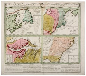 |
Homann Heirs, DOMINIA ANGLORUM IN AMERICA SEPTENTRIONAL DIE GROS-BRITANISCHE COLONIE-LAENDER IN NORD-AMERICA...; A. NEW FOVNDLAND, od. TERRA NOVA...; B. NEW ENGELLAND NEW YORK NEW YERSEY und PENSILVANIA; C. VIRGINIA und MARYLAND; and CAROLINA...von FLORIDA.,Nuremberg, c. 1740 |
|
1741 |
|
 |
Guillaume De l’Isle, "Carte du Canada ou de la Nouvelle France et des decouvertes qui y ont été faites ... / dressée ... par Guillaume De l’isle." A Amsterdam : Chez J. Cóvens et C. Mortier, ca. 1741 |
 |
J. A., Richtern, Planispar.Ter.Cum.Globo Coel et Terr. Et Sphaermii Engraved by Bernige roth Leipzig 1741 |
|
1743 |
|
 |
Jacques-Nicolas Bellin, CARTE DE L'AMERIQUE SEPTENTRIONAL Pour servir ŕ l'Histoire de la Nouvelle France, Dressé par N. B. Ing du Roy, et Hydrog. de la Marine, 1743 |
|
1744 |
|
|
|
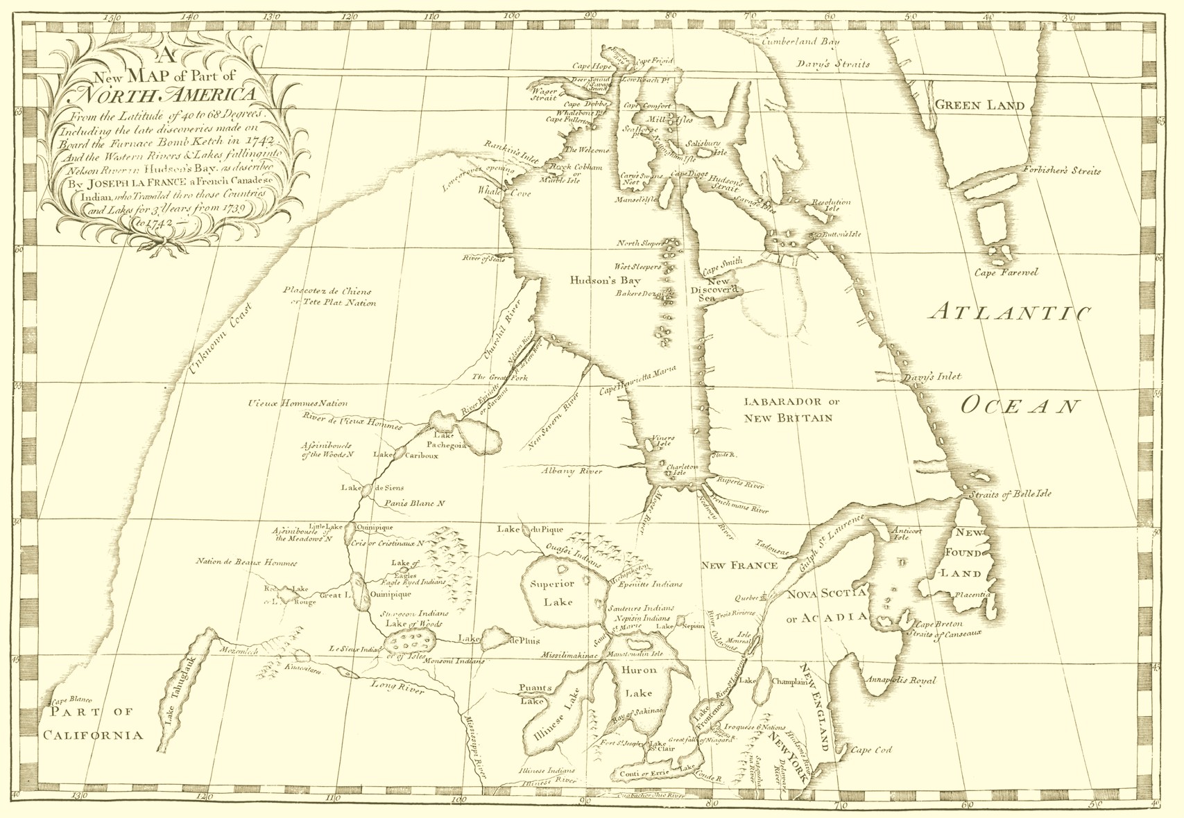
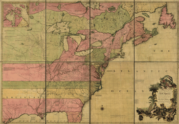
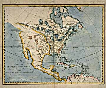
Joseph La France, A New Map of Part of North America From the Latitude of 40 to 68 Degrees ... [1744] |
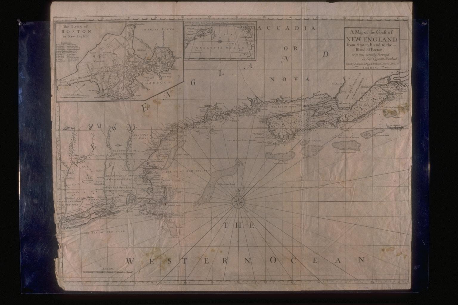 |
A Map of
the Coast of NEW ENGLAND, from Staten Island to the Island of Breton
... The Town of BOSTON in New England ...
[© Osher Map Library and Smith Centre for Cartographic Education, University of Southern Maine - [1744 published in 1775, The English Pilot ...] |
|
1745 |
|
| From: New England Bravery: Being a full and true Account of the taking of the City of Louisbourg, by the New-England Forces under the Command of the gallant General Pepperell, on the 17th of June, 1745. Woodcut. Massachusetts Historical Society Collections, vol. 75 (1922): 117. | |
|
1746 |
|
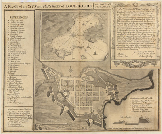 |
Richard Gridley, A Plan of the City and Fortress of Louisbourg, with a Small Plan of the Harbour, 1745, engraving by P. Pelham. Boston: Published by J. Smibert, 1746. |
 |
Homann Heirs,AMERICAE MAPPA GENERALIS SECUNDUM LEGITIMAS PROJECTIONIS... Nuremburg, 1746 |
|
1747 |
|
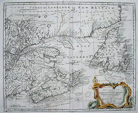 |
Emanuel Bowen, A new & accurate map of the islands of Newfoundland, Cape Briton, St. John and Anticosta; together with the neighbouring countries of Nova Scotia, Canada &c. Drawn from the most approved modern maps and charts, and regulated by astronl. observatns. By Eman. Bowen. (London: Printed for William Innys, Richard Ware, Aaron Ward, J. and P. Knapton, John Clarke, T. Longman and T. Shewell, Thomas Osborne, Henry Whitridge ... M.DCC.XLVII) |
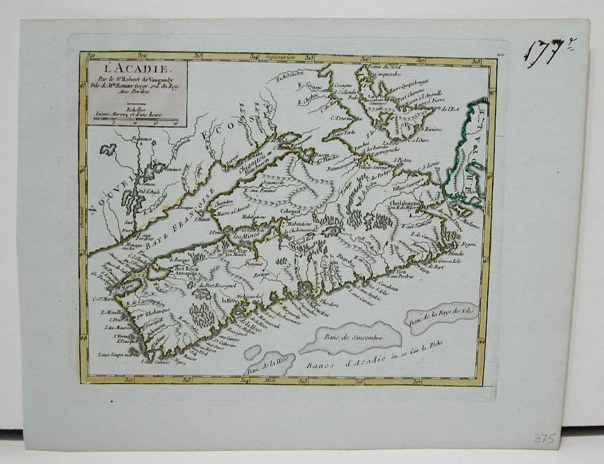 |
Robert de Vaugondy, L'Acadie par le Sr. Robert de Vaugondy, c. 1749. |
|
1750 |
|
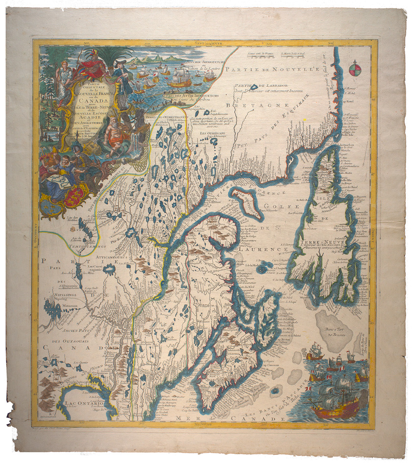 |
Matthaeus Seutter. Partie orientale de la Nouvelle France ou du Canada avec l'Isle de Terre-Neuve et de Nouvelle Ecosse, Acadie et Nouv. Angleterre avec fleuve de St. Laurence / representé par Math. Seutter, geogr. de S. M. Impér. d'Augsbourg [Augsburg : s.n., ca. 1750] [© McGill University, 72 dpi - G3400 1750 S4 RBD Map] |
|
1753 |
|
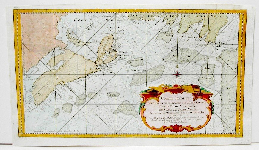 |
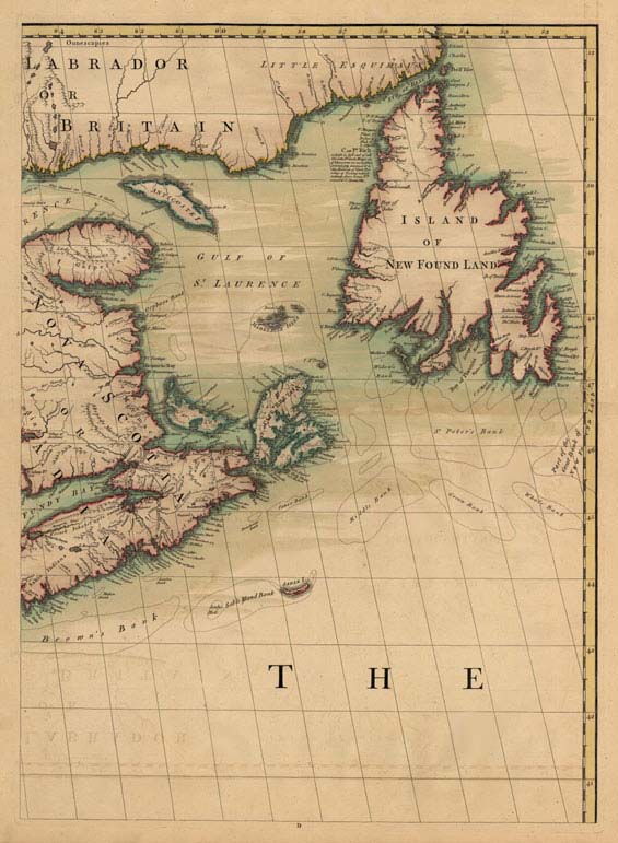
Joseph Bernard Marquis de Chabert, Carte Reduite des Costes de l'Acadie, de l'Isle Royale, et de la Partie Meridionale de l'Isle de Terre-Neuve. Dressee sur les Observations faites par Ordre du Roi en 1750 et 1751. Paris: Voyage fait par ordre du Roi en 1750 et 1751, dans L'Amerique Septentrionale ---, Paris 1753. |
|
1754 |
|
 |
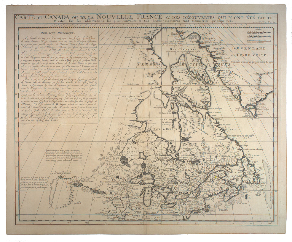
Jacques-Nicolas Bellin. Carte réduite du golphe de St. Laurent: contenant L'Isle de Terre-Neuve et partie de la coste des Esquimaux, L'Isle Royale, L'Isle St. Jean et celle d'Anticosti &c. dressée au Depot des Cartes et plans et journaux de la Marine, pour le Service des vaisseaux du Roi, par ordre de M. Rouville, Chr. Comte de Jouy &c. Ministre et secretaire d'Etat ayant le Departement de la Marine, M.DCC.LIV[Paris]: Depot de la Marine, 1754. [© McGill University, 72 dpi - G3402.S2P5 1754 B4 RBD Map] |
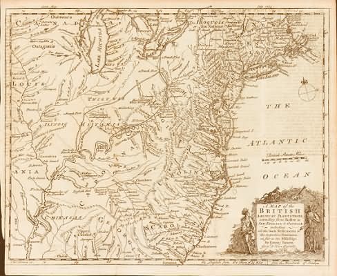 |
Emanuel Bowen, A Map of the British American Plantations, extending from Boston in New England to Georgia, including all the back Settlements in the respective Provinces, as far as the Mississippi. From Gentleman's Magazine, London: July 1754. |
|
1755 |
|
|
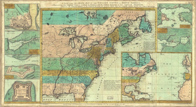
A new and accurate map of the English empire in North America; Representing their rightful claim as confirmed by charters and the formal surrender of their Indian friends; likewise the encroachments of the French, with the several forts they have unjustly erected therein. Society of Anti-Gallicans. Sold by Wm. Herbert & Robt. Sayer, London, 1755. Hand colored. Relief shown pictorially. Maps in margin: A plan of the harbor and town of Louisbourg on the isle of Cape Briton.--A plan of Chebucto Harbor.--The Atlantic Ocean.--Fort Frederick built by the French at Crown or Scalp Point in the year 1731.--A plan of Port Dauphin on the isle of Cape Briton.--A plan of the harbour of Annopolis Royal.--A plan of the town of Quebeck. [Source: DIGITAL ID: g3300 ar006200 URL: http://hdl.loc.gov/loc.gmd/g3300.ar006200 © Library of Congress Geography and Map Division Washington, D.C.] |
 |
J. N. Bellin, Carte de l'Amerique Septentrionale Depuis le 28 Degré de Latitude jusqu'au 72 ... Remarques Les Possessions en Francois sont colorées en Bleu, Celles des Anglois en Jaune, Et celles des Espagnols en Rouge ... [1755] |
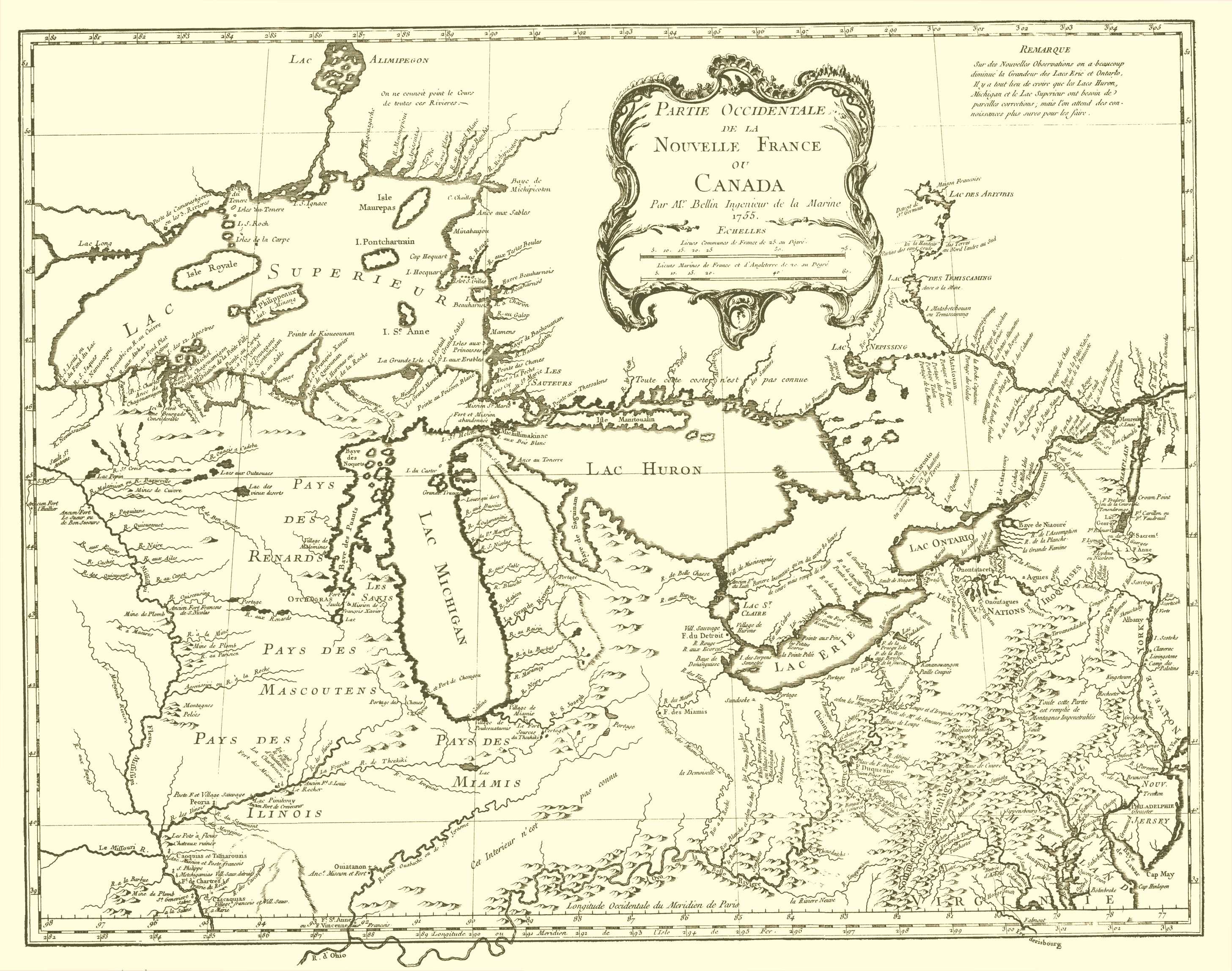 |
J. N. Bellin, Partie Occidentale de la Nouvelle France ou Canada ... 1755 |
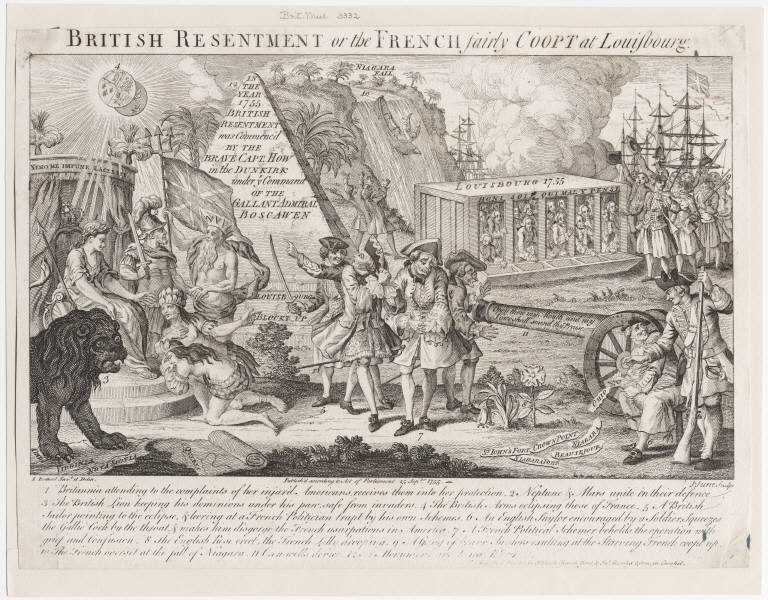 |
L.P. Boitard, British Resentment or the French fairly Coopt at Louisbourg, March -November, 1755. |
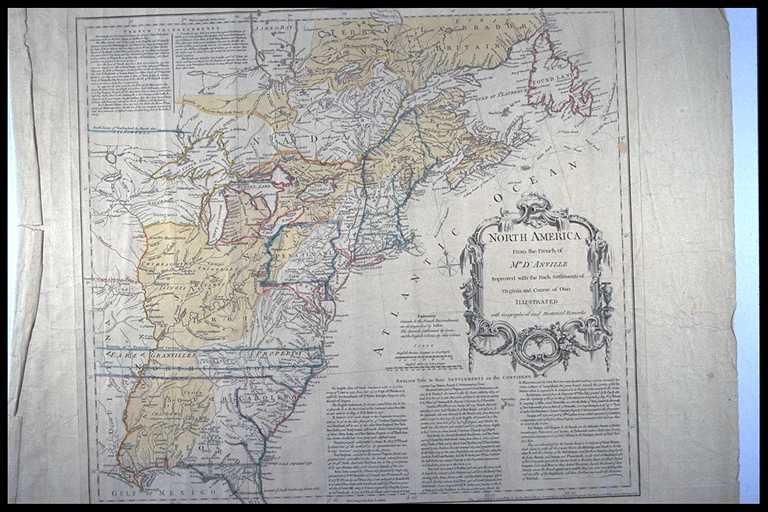 |
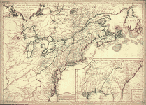
Thomas Jefferys, North America from the French of Mr. D’Anville Improved with the Back Settlements of Virginia and Course of Ohio Illustrated with Geographical and Historical Remarks.” London: Published by Thomas Jefferys, 1755. (Boston, 1755). [© McMaster University Library, Research Collections - Accession # 4249] |
|
Thomas Kitchin, From (portion) and John Mitchell, “A Map of the British and French Dominions in North America with the Roads, Distances, Limits, and Extent of the Settlements Humbly Inscribed to the Right Honourable The Earl of Halifax and the Other Right Honourable The Lords Commissioners For Trade and Plantations by their Lordships Most Obliged and very Humble Servant Jn. Mitchell.” Engraving by Thomas Kitchin. London: Published by John Mitchell, 1755. - Go to Osher Map Library, University of Southern Maine for a complete description of the Mitchell Map |
 |
Laccadie Paris c. 1755 |
 |
Georges-Louis Le Rouge, Canada et Louisiane, par le Sr. le Rouge ingénieur géographe du Roy. Paris, 1755. |
 |
Georges-Louis Le Rouge, Partie orientale du Canada, traduitte de l'anglois de la carte de Jefferys publiée a Londres en May 1755. Paris [1755?] |
 |
J. Lodge, A Map of the British and French Settlements in North America, Gentleman’s Magazine, London, [1755]. |
 |
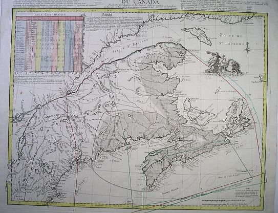
Isaak Tirion, NIEUWE KAART VAN DE GROOTBRITTANNISCHE VOLKPLANTINGEN IN NOORD AMERICA, Amsterdam, 1755 |
 |
Sr. Robert de Vaugondy, Partie de L'Amérique Septent qui comprend La Nouvelle France ou Le Canada ... 1755 |
|
1756 |
|
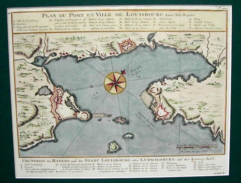 |
Jacques-Nicolas Bellin, "Plan du port et ville de Louisburg dans l'isle Royale ... Grundriss des Hassen un der Stadt LOUISBOURG oder LUDWIGSBURG auf der Koennigs-Inbsel; Leipzig: Arkstee & Merkus in Allgemeine Historie der Reisen zu Wasser und zu Lande, c. 1756 |
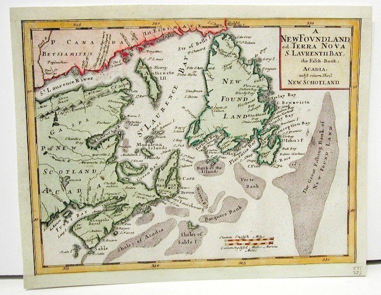 |
Homann Heirs, A. NewFovndland, of. Terra Nova S. Lavrentii Bay, die Fisch-Bank, Acadia, nebst einem Theil New Schotland.Nuremberg, c. 1756 |
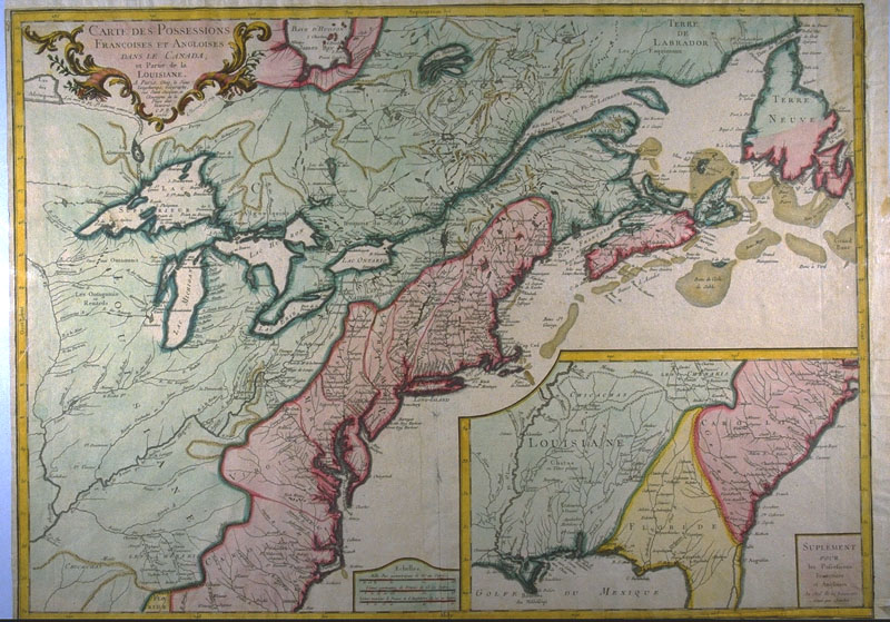 |
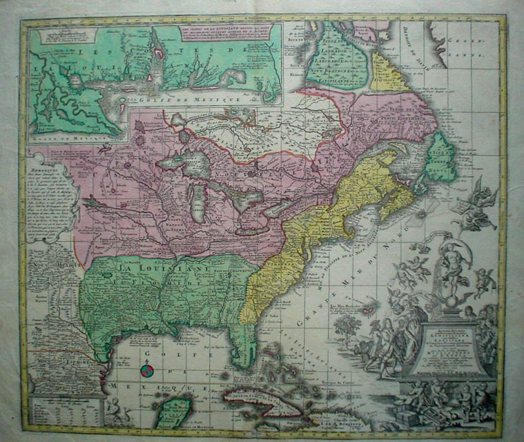
S. G. Longchamps, CARTE DES POSSESSIONS FRANÇOISES ET ANGLOISES DANS LE CANADA, et Partie de la LOUISIANE; SUPPLEMENT POUR les Possessions Françoises et Angloises Au Sud de la Louisiane. Gravé par Chambon.; A Paris, Chés le Sieur Longchamps, Geographe, rue Saint Jacques, a l'Ensiegne de la Place des Victoires. C.P.R. 1756. Livre XIII. Published 1756 [© McMaster University Library, Research Collections - Accession # 106785] |
 |
Jean Baptiste Nolin, Carte du Canada et de la Louisiane qui forment la Nouvelle France et des colonies angloises ou sont representez les pays contestez. Paris, Chez Daumont, 1756. |
|
|
|
|
1757 |
|
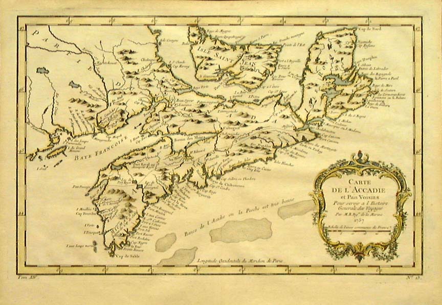 |
Jacques-Nicolas Bellin, "Carte De L'Accadie et Pais Voisins Pour Servir a L'Histoire Generale des Voyages. Par. M. B. Ingr. de la Marine”. Paris 1757. |
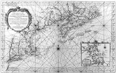 |
Jacques-Nicolas Bellin, Carte Reduite des Costes Orientales de l'Amerique Septentrionale. 1st Feuille Contenant l'Isle Royale, l'Accadie, la Bay Francoise, la Nouvelle Angleterre et la Nouvelle Yorc …Dressée au Depost des Cartes et Plans de la Marine / Pour le Service des Vaisseaux du Roy. [1757] |
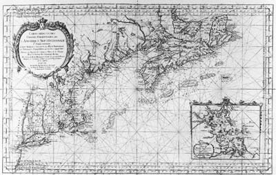 |
Jacques-Nicolas Bellin, Carte Reduite des Costes Orientales de l'Amerique Septentrionale. 1st Feuille Contenant l'Isle Royale, l'Accadie, la Bay Francoise, la Nouvelle Angleterre et la Nouvelle Yorc … Dressée au Depost des Cartes et Plans de la Marine / Pour le Service des Vaisseaux du Roy. [1757] - [Revised - Note the new series of rhumb lines] |
|
1758 |
|
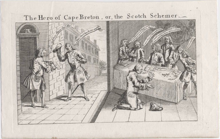 |
The hero of Cape Breton, or, the Scotch Schemer, 1758 |
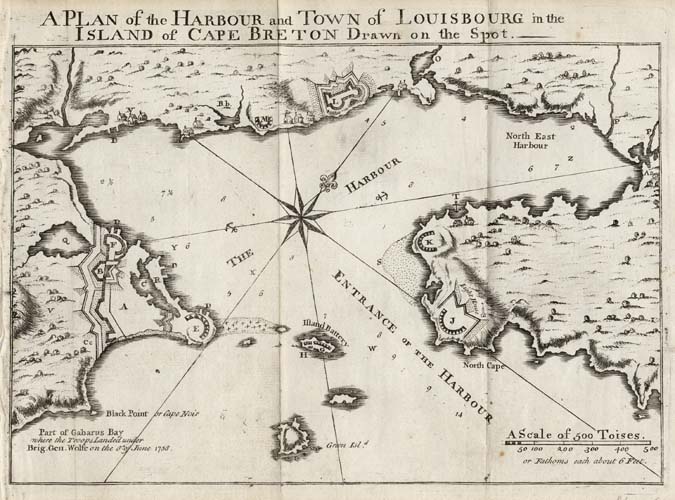 |
A Plan of the Harbour and Town of Lewisbourg in the Island of Cape Breton Drawn of the Spot, Published in the Gentlemans & London Magazine, August 1758. |
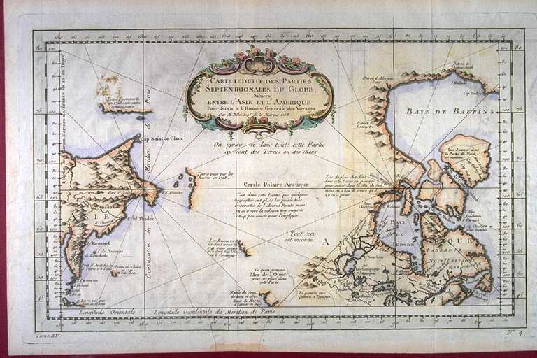 |
Jacques-Nicolas Bellin, CARTE REDUITE DES PARTIES SEPTENTRIONALES DU GLOBE, Situées ENTRE L'ASIE ET L'AMERIQUE Pour servir a l'Histoire Generale des Voyages Par M. Bellin Ingr. de la Marine 1758. Tome XV. No. 4. Published 1758 [© McMaster University Library, Research Collections - Accession # 107033] |
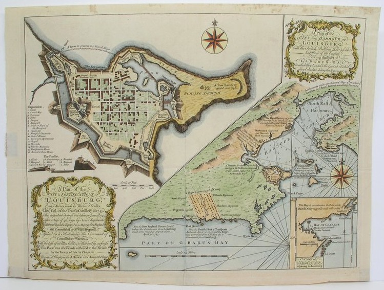 |
Richard, Gridley, A Plan of the City & Fortifications of Louisburg, from a Survey Made by Richard Gridley, Lieut. Col. of the Train of Artillery in 1745. / A Plan of the City and Harbour of Louisburg, with the French Batteries that Defended It; and Those of the English, Shwing that Part of Gabarus Bay, in which they Landed, & The Ground on Which they Encamped during the Sige in 1745. London: Universal Magazine, 1758 |
 |
Gilles Robert de Vaugondy, Partie de l'Amérique septent qui comprend la Nouvelle France ou le Canada / par le Sr. Robert de Vaugondy, géog ordinaire du roy. Avec privilege 1755 ; C. Haussard, sculp[Paris : Chez l'auteur, 1758].[ © McGill University, 72 dpi - G3402.S3 1755 R6 RBD Map] |
|
1759 |
|
 |
Homann Erben, Dominia Anglorum in America Septentrionali. Specialibus mappis Londini primum a Mollio edita, nunc recusa ab Homannianis Hered. [Norimbergć, 1759] |
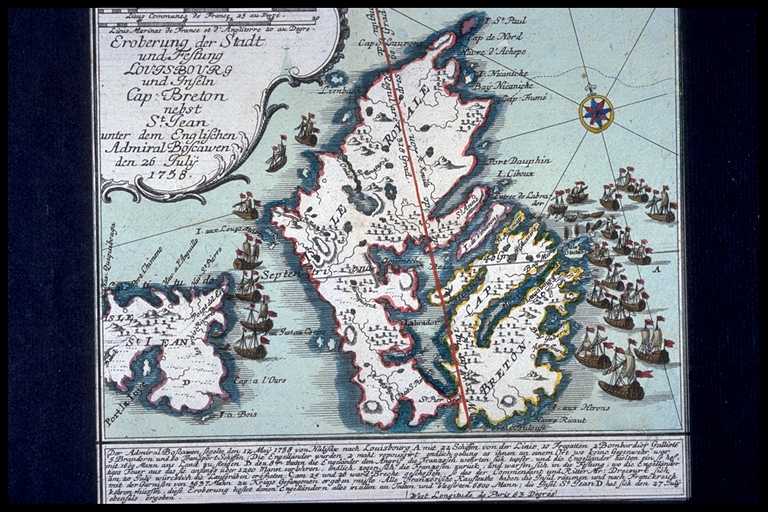 |
Christian Friederich van der Heyden, Eroberung der Stadt und Festung LOUISBOURG und Inseln Cap: Breton nebst St. Jean unter dem Englischen Admiral Boscawen den 26 July 1758. Published, 1759 [© McMaster University Library, Research Collections - Accession # 4255] |
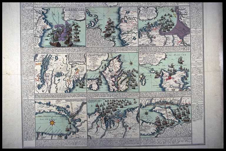 |
Christian Friederich van der Heyden, KARTE derer ENGLISCHEN UNTERNEHMUNGEN zur SEE auf denen Französischen Küsten desglei chen in denen Französischen Colonien in AFRICA und dem Mitternaechtlichen AMERICA aus denen beste / Relationen u: besondern Nachrichten gezogen, u: nach denen besten Geograph: und Topohtsphische Karten, mit beobach / tung der Longitudou: Latitudo derer entseriste Gegenden, gezeichnet, u: mit Historischen Anmerckunque erläutert durch C.F.v.H. ANNO 1759. CARTE des ENTREP: ANGLO:ISES par MER sur les Cotes de FRANCE aussi dans les Colonies Francoises en AFRIQUE et en AMERIQUE Septentrionale tirées des mellieurs Relations et Auis Speciels et Suivant les meilleures Cartes Geographiques et Topographiques, avec les Observations de Longitude et Latitude, de Signée et expliquée avec des Remarques Historiques par C.F. de H. , published in 1759 [© McMaster University Library, Research Collections - Accession # 4250] |
|
1760 |
|
 |
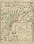
Anonymous, A NEW MAP OF CANADA, Also the North Parts of NEW ENGLAND and NEW YORK; with NOVA SCOTIA and NEWFOUND LAND; SUPPLEMENT for the LAKES of CANADA. From the Sr. Robert with Improvements. Anonymous, second state, [1760] [© McMaster University Library, Research Collections, Accession # 107315] |
 |
Jacques-Nicolas Bellin, Plan du Fort et Ville de Louisbourg dans l’Isle Royale), Paris, [1760] |
 |
Jacques-Nicolas Bellin, Karte Von L’Isle Royal ..., Paris, [1760] |
 |
Thomas Jefferys, A MAP of CANADA and the NORTH PART of LOUISIANA / with the ADJACENT COUNTRYS. By Thos. Jefferys, Geographer to His Royal Highness the PRINCE of WALES. T Jefferys sculp. Published 1760 [© McMaster University Library, Research Collections - Accession # 106455] |
|
1762 |
|
|
J. Gibson, An Accurate Map of the British Empire in Nth. America as settled by the Preliminaries in 1762), Gentleman’s Magazine, London, [1762] |
|
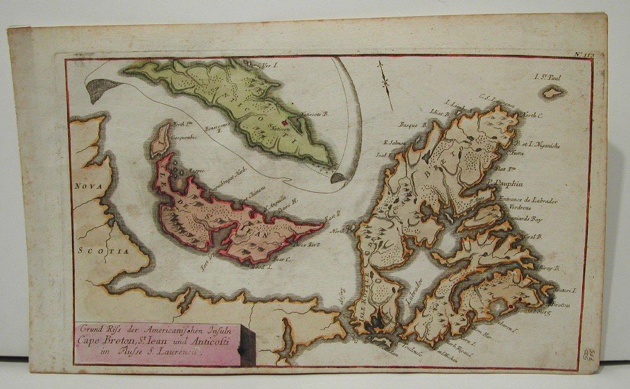
Grund Riss der Americanischen Insuln Cape Breton, St.Iean und Anticosti im Flusse S.Laurencii. Nurnberg: Raspe, c. 1762 |
 |
Didier Robert de Vaugondy. Canada, Louisiane, possessions angl par le S. Robert de Vaugondy, géog ord du roi, de S.M. Polonoise Duc de Lorr et de Bar, et de la Société royale de Nanci. Avec privilege 1762.Paris : Chez l'auteur, 1762. [© McGill University, 72 dpi - G3300 1762 R62 RBD Map] |
|
1763 |
|
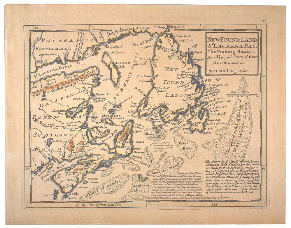 |
Herman Moll. New Found Land, St. Laurence Bay, the fishing banks, Acadia, and part of New Scotland / by H. Moll, geographer.[London : J. & C. Bowles, 1763?]. [© McGill University, 72 dpi - G3410 1763 M6 RBD Map\] |
|
|
1764 |
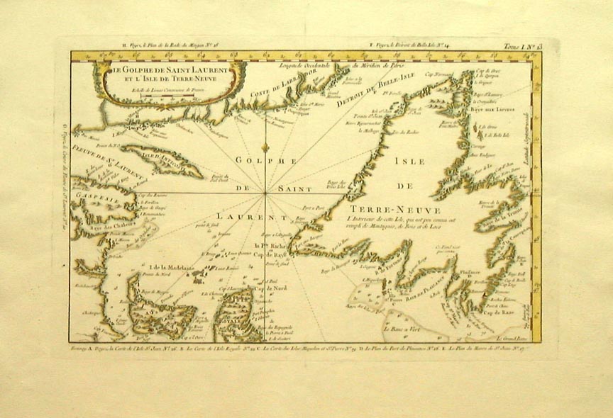 |
Jacques-Nicolas Bellin, "Le Golphe De Saint Laurent Et L'Isle De Terre Neuve.” Paris, 1764. |
 |
Jacques-Nicolas Bellin, La Nouvelle France oů Canada. [Paris, 1764] |
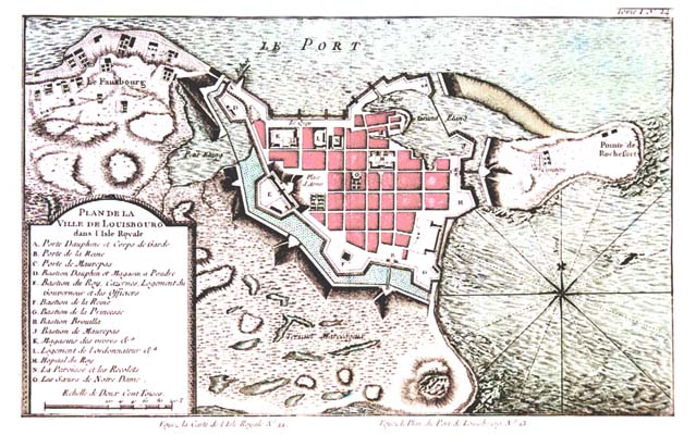 |
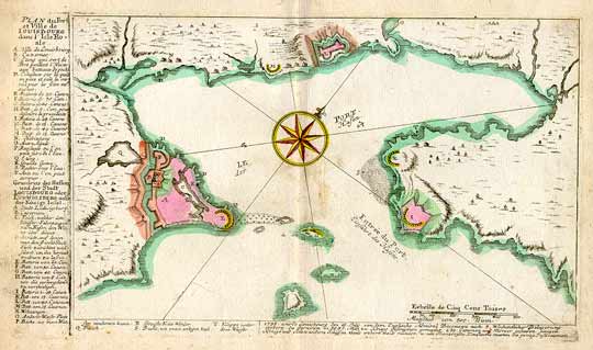
Jacques-Nicolas
Bellin, Plan de la Ville de Louisbourg, dans l' Isle Royale [Petit
Atlas Maritime - 1764 - Tome I, No. 24;
Voyez la carte de l'Isle Royale No. 22; Voyez le Plan du Port
de Louisbourg No. 23]
A.
Porte Dauphine et Corps de Garde [Note: Louisourg may indeed have a copy. When accessioned, this reference will be transferred to the Archives Database] |
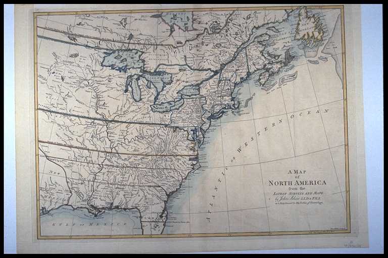 |
Reverend John Blair, A MAP of NORTH AMERICA from the LATEST SURVEYS AND MAPS by John Blair L.L.D. & F.R.S. as a Supplement to His Tables of Chronology. Thos. Kitchin Sculpsit Published c. 1768 [© McMaster University Library, Research Collections - Accession # 106457] |
|
1769 |
|
 |
Louis Charles Desnos, Carte des possessions françoises et angloises dans le Canada, et partie de la Louisiane, 1756. L. Thevenard fil. sculp. Longchamps, géographe. [1769]From Louis Charles Desnos' Atlas général. 1767-[69] |
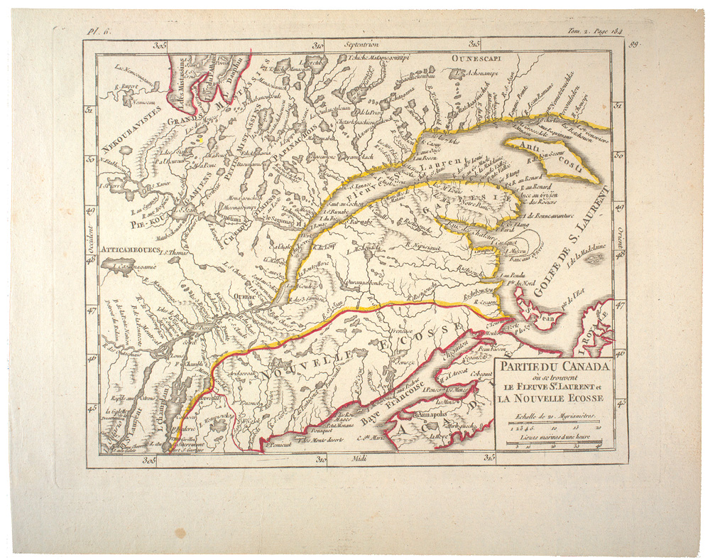 |
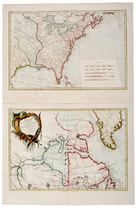
Didier Robert de Vaugondy. Partie du Canada oů se trouvent le Fleuve St. Laurent et La Nouvelle Ecosse [Paris : s.n., 1769]. [© McGill University, 72 dpi - G3402.S3 1769 R6 RBD Map] |
|
1771 |
|
 |
Rigobert Bonne, PARTIE DE L'AMERIQUE... & "CANADA..., 1771 |
|
1775 |
|
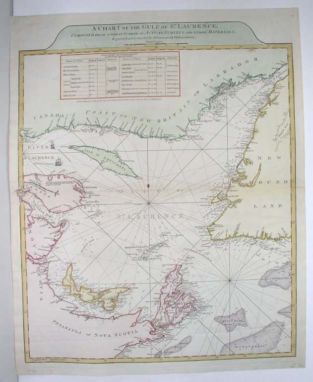 |
Thomas Jefferys, A chart of the gulf of St. Lawrence Composed from a Great Number of Actual Surveys and other Materials, Regulated and Connected by Astronomical Observations. London: Sayer & Bennett, c. 1775. |
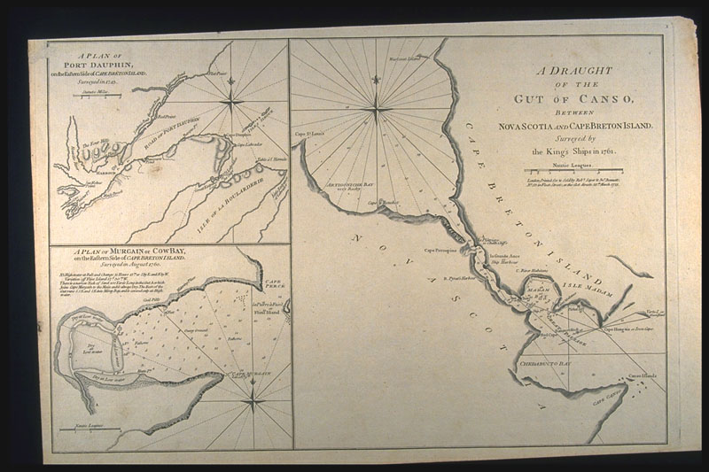 |
A DRAUGHT OF THE GUT OF CANSO, BETWEEN NOVA SCOTIA AND CAPE BRETON ISLAND, Surveyed by the King's Ships in 1761; A PLAN OF PORT DAUPHIN, on the Eastern Side of CAPE BRETON ISLAND, Surveyed in 1743; A PLAN OF MURGAIN or COW BAY, on the Eastern Side of CAPE BRETON ISLAND, Surveyed in August 1760; London. Robert Sayer and John Bennett, 1775 [© McMaster University Library, Research Collections - Accession # 4151] |
-----------
|
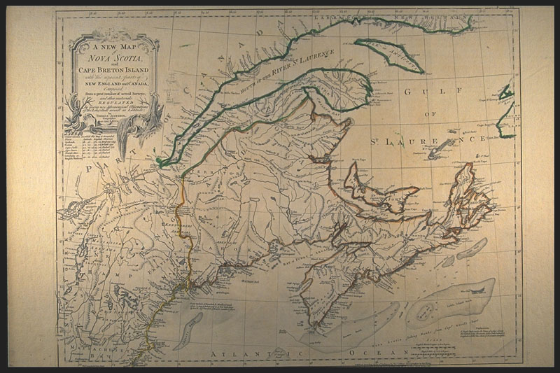
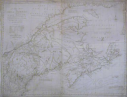
Thomas.
Jefferys, A NEW MAP of NOVA SCOTIA, and CAPE BRETON ISLAND with
the adjacent parts of NEW ENGLAND and CANADA, Composed from a
great number of actual Surveys; and other materials REGULATED by many
new Astronomical Observations of the Longitude as well as Latitude; by
THOMAS JEFFERYS, Geographer TO THE KING. VII Published according
to Act of Parliament by Thos. Jefferys. Geographer to the King.
London, Printed & Sold by R. Sayer & J. Bennett, No. 53, in
Fleet Street. 15 June 1775. [© McMaster University Library, Research
Collections - Accession # 6259/60]
------------ A new map of Nova Scotia, and Cape Breton Island with the adjacent parts of New England and Canada, composed from a great number of actual surveys; and other materials regulated by many new astronomical observations of the longitude as well as latitude; by Thomas Jefferys, geographer to the King." Printed & sold by R. Sayer & J. Bennett, London, 1775. Hand colored. Relief shown pictorially. Shows Maritime Provinces, New England, and St. Lawrence Valley region to Montreal. From the author's The American atlas. 1775. [DIGITAL ID: g3420 np000010 URL: http://hdl.loc.gov/loc.gmd/g3420.np000010 Source: © Library of Congress Geography and Map Division Washington, D.C] |
|
1776 |
|
 |
Matthew Albert Lotter, CARTE NOUVELLE DE L'AMERIQUE ANGLOISE CONTENANT TOUT CE QUE LES ANGLOIS POSSEDENT SUR LE CONTINENT DE L'AMERIQUE SEPTENTRIONALE SAVIOR LE CANADA, LA NOUVELLE ECOSSE OU ACADIE, LES TREIZE PROVINCE UNIES..., Augsbourg, c. 1776 |
|
|
1777 |
 |
Homann Heirs, AMERICA SEPTENTRIONALIS A DOMINO D'ANVILLE IN GALLIIS EDITA NUNC IN ANGLIA COLONIIS IN INTERIOREM VIRGINIAM DEDUCTIS NEC NON FLUVII OHIO CURSU..., Nuremberg, 1777 |
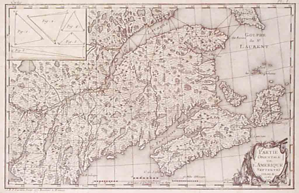 |
J.B. Tardieu, "Partie Orientale de L'Amerique Septentrionale." 1777 (Drawn by J.B. Tardieu in 1762) |
|
1778 |
|
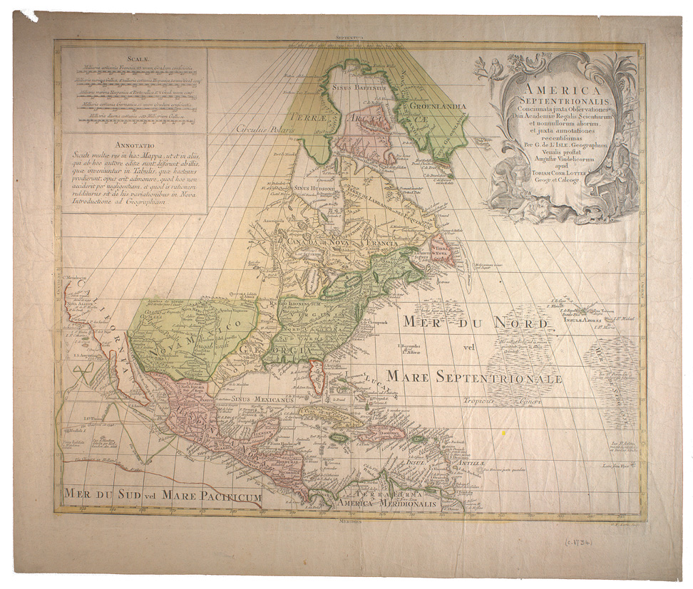 |
Georg Friedrich Lotter. Ameörica Septentrionalis : concinnata juxta observationes Dnn Academi' Regalis Scientiarum et nonnullorum aliorum, et juxta annotationes recentissimas per G. de L'Isle, geographum. Venalis prostat August' Vindelicorum apud Tobiam Conr. Lotter, geogr. et calcogr. -- Augsburg : Tobias Conrad Lotter, [1778?]. [© McGill University, 72 dpi - G3300 1778 L6 RBD Map] |
|
Gilles Robert de Vaugondy. Partie de l'Amérique septent qui comprend la Nouvelle France ou le Canada par le Sr. Robert de Vaugondy, géog ordinaire du roy. Avec privilege ; Groux.[Paris: Chez l'auteur, 1778]. [© McGill University, 72 dpi - G3402.S3 1778 R6 RBD Map] |
 |
Gilles Robert de Vaugondy. Carte du Canada et des Etats-Unis de l'Amérique Septentrionale par le Sr. Robert de Vaugondy, Géog. Ord. du Roi ... et Censeur Royal. Paris : Chez Fortin, Ing'r mécanicien du Roi pour les globes et sphčres, 1778. |
|
1780 |
|
|
|
R. Bonne, L’Isle de Terre-Nueve, l’Acadie ou la Nouvelle Escosse, l’Isle St. Jean, et la Partie Orientale du Canada, Geneva 1780 |
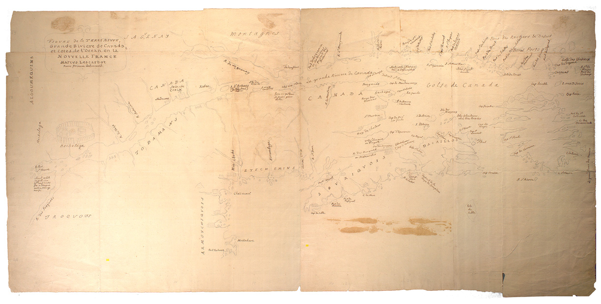 |
Marc Lescarbot. Figure de la Terre Neuve, Grande rivičre de Canada, et Côtes de l'Océan en la Nouvelle France Marcus Lescarbot, nunc primum delineavit [© McGill University, 72 dpi - G3402 S3 1609 L3 1780z RBD Map] |
 |
M De Sartine, Carte Reduite des cotes orientales de l'Amerique Septentrionale Contenant Celles des Provinces de New-York et de la Nouvelle Angleterre, celles de l'Acadie ou Nouvelle Ecosse, de l'Ile Royale de l'Ile de St. Jean, avec l'interieur du Pays. Paris: Departement de la Marine , c. 1780 |
|
|
1781 |
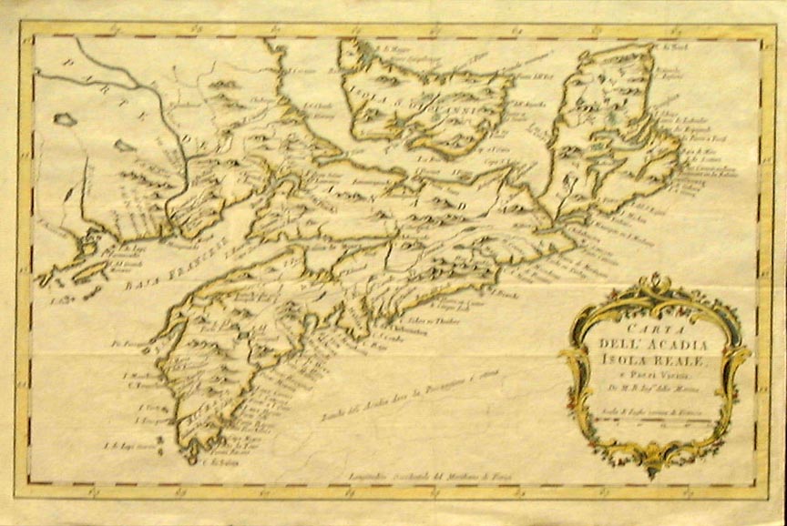 |
Jacques-Nicolas Bellin, "Carta Dell'Acadia Isola Reale e Paesi Vicini Di M. B. Ingr della Marina." Venice 1781. From the Teatro Della Guerra Maritima, the Italian edition of Bellin's “Petit Atlas Maritime”. |
|
|
1784 |
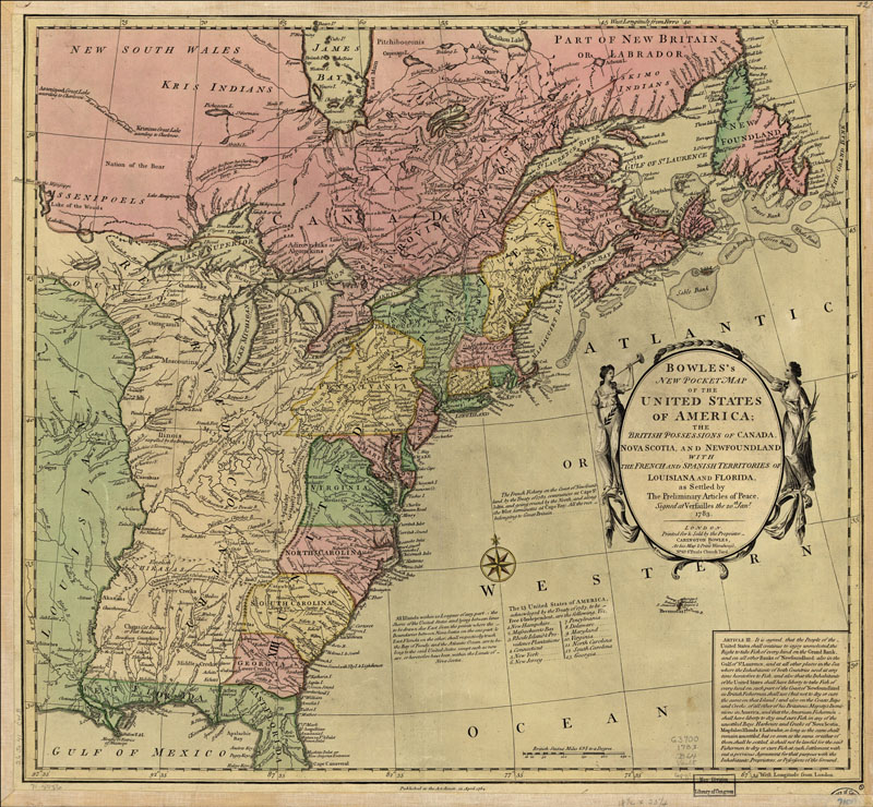 |
Carington Bowles, Bowles's new pocket map of the United States of America; the British possessions of Canada, Nova Scotia, and Newfoundland, with the French and Spanish territories of Louisiana and Florida, as settled by the preliminary articles of peace signed at Versailles the 20th. Jany. 1783.London, 1784. |
|
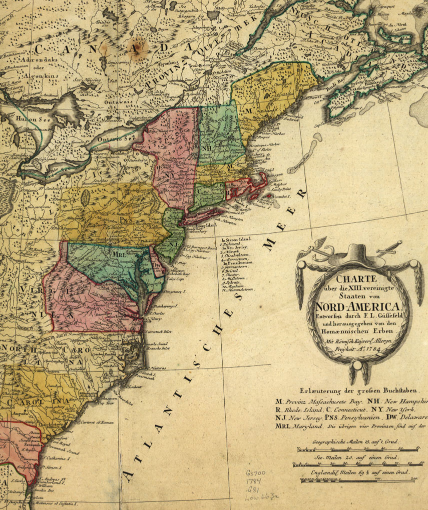
F. L.
Güssefeld, Charte über de XIII Vereinigte Staaten von Nord-America,
entworfen durch F. L. Güssefeld und hrsg. von den Homćnnischen Erben.
" Title in margin: Les XIII Etats Unis de l'Amerique septentrionale,
d'apress les meilleures & speciales carte angloises qui ont parues
jusqu'ci. " From publisher's Atlas geographicvs. 1759 [i.e. 1784]
v.3, no. 65. [© DIGITAL ID: g3700 ar075703 URL: http://hdl.loc.gov/loc.gmd/g3700.ar075703 SOURCE: Library of Congress Geography and Map Division Washington, D.C.] |
 |
Gerard Hulst van Keulen, A NEW CHART OF THE COAST OF NEW ENGLAND, NOVA SCOTIA and the ISLANDS of S.T JOHN, CAPE BRETON, SABLE, THE BANKS OF S.T PETERS, MIZEN, BANQUEREAU, PORPOISE, MIDDLE, SABLE ISLAND, BROWNS, CAPE SABLE, IEFFERYS, and with Part of S.T GEORGES BANK; These Chartz are Followed, according tho them Executed by ORDER of the LORDS COMMISSIONERS, of the ADMIRALTY in ENGLAND: To be Sold at AMSTERDAM By G. HULST van KEULEN. Anno 1784. |
 |
Remondini, CARTE GÉNÉRALE DU CANADA, DE LA LOUISIANE, DE LA FLORIDE, DE LA CAROLINE, DE LA VIRGINIE, DE LA NOUVELLE ANGLETERRE, ETC PAR LE SR. D'ANVILLE... [Santini (1776)], c. 1784 |
|
1785 |
|
 |
Thomas Kitchin, NORTH / AMERICA Drawn from the best Authorities By T. Kitchin. Published 1785? [© McMaster Library, Research Collections - Accession # 107301] |
 |
J. A. Murray, A New Map of Nova Scotia and Cape Breton with the Adjacent Parts of New England and Canada …, Publish’d as the Act directs 31st July 1785 by J. Murray. No.32 Fleet Street [London] |
|
1792 |
|
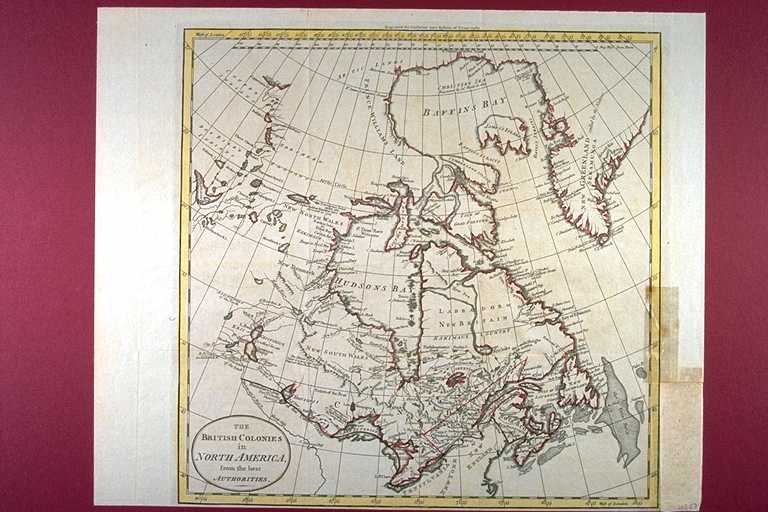 |
William Guthrie, THE BRITISH COLONIES in NORTH AMERICA, from the best AUTHORITIES. Engraved for Guthrie's New System of Geography Published [1792?] [© McMaster University Library, Research Collections - Accession # 107046] |
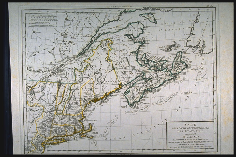 |
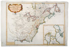
Pierre Francois Tardieu, CARTE / DE LA PARTIE SEPTENTRIONALE DES ETATS UNIS, comprenant LE CANADA, LA NOUVELLE ECOSSE, NEW HAMPSHIRE, MASSACHUSET'S BAY, RHODE-ISLAND, CONNECTICUT, NEW-YORCK, ETAT DE VERMONT avec partie de Pensilvanie et de New-Jersey. [c. 1792] [© McMaster University Library, Research Collections - Accession # 4151] |
|
1794 |
|
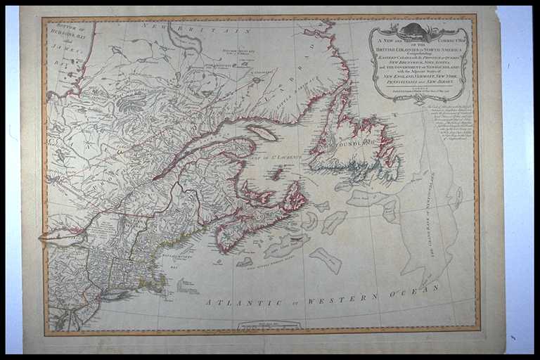 |
A NEW AND CORRECT MAP OF THE BRITISH COLONIES IN NORTH AMERICA Comprehending EASTERN CANADA with the PROVINCE OF QUEBEC, NEW BRUNSWICK, NOVA SCOTIA, and THE GOVERNMENT OF NEWFOUNDLAND: with the Adjacent States of NEW ENGLAND, VERMONT, NEW YORK, PENNSYLVANIA and NEW JERSEY. LONDON. Publish'd by Laurie & Whittle 53 Fleet Street, 12th May, 1794 [© McMaster University Library, Research Collections - Accession # 4405] |
 |
Eastern North American portion of: A NEW MAP OF THE WHOLE CONTINENT / OF AMERICA, DIVIDED INTO NORTH AND SOUTH AND WEST INDIES. wherein are exactly Described THE UNITED STATES OF NORTH AMERICA as well as THE SEVERAL EUROPEAN POSSESSIONS according to the Preliminaries of Peace signed at Versailles Jan. 20 1783. Compiled from MR. D'ANVILLE'S MAPS of that Continent, with the addition of the Spanish Discoveries in 1775 to the North of California & Corrected in the several Parts belonging to GREAT BRITAIN, from the Original Materials of GOVERNOR POWNALL, MP / LONDON. Published by LAURIE & WHITTLE, No. 53, Fleet Street. / as the Act directs, 12th. May 1794. [© McMaster University Library, Research Collections - Accession # 4403] |
|
1795 |
|
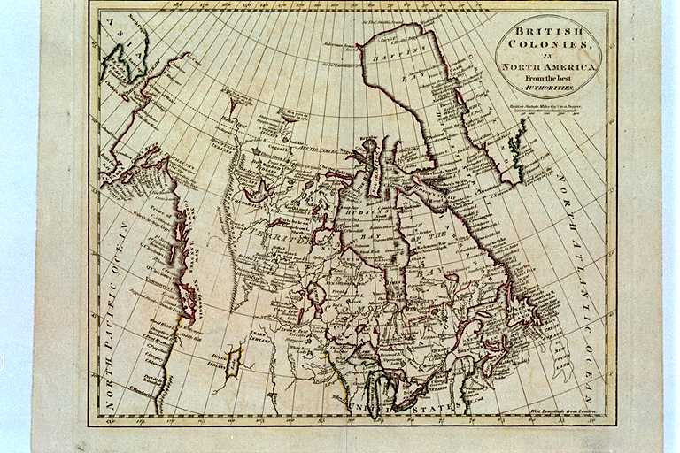 |
BRITISH COLONIES, IN NORTH AMERICA. From the best AUTHORITIES. Plate XXIII. [c. 1795?] [© McMaster University Library, Research Collections - Accession # 107029] |
|
1796 |
|
 |
John Wilkes, NORTH AMERICA. London Pubd. as the Act directs October 22d. 1796, by J. Wilkes. Neele sc. 352, Strand. Published 1796 [© McMaster University Library, Research Collections - Accession # 106777] |
|
1797 |
|
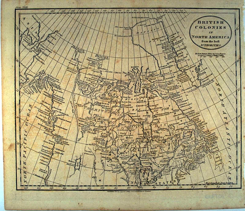 |
Charles Dilly, BRITISH COLONIES IN NORTH AMERICA from the best AUTHORITIES. Plate XXIII: Published Novr. 21, 1797 by C. Dilly & G.G. &. J. Robinson, London. Published 1797. [© McMaster University Library, Research Collections, Accession # 107310] |
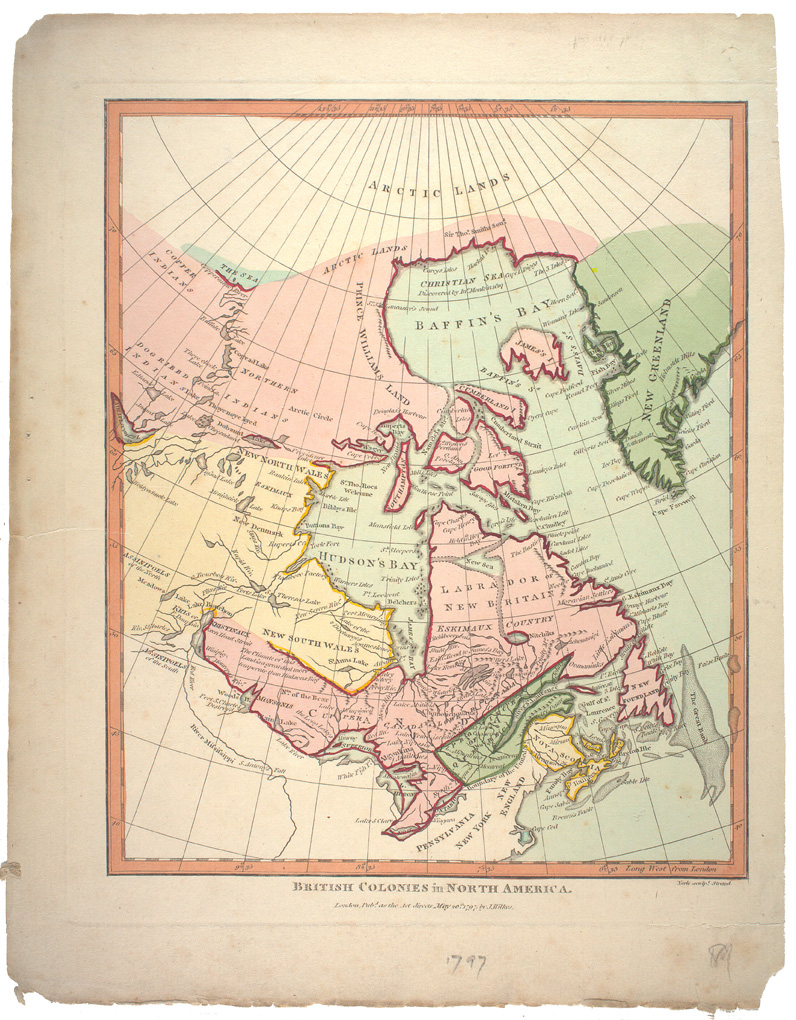 |
John Wilkes. British Colonies in North America London, Pub. as the Act directs May 20th 1797 by J. Wilkes London : J. Wilkes, 1797. [© McGill University, 72 dpi - G3300 1797 W54 RBD Map] |