|
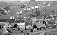
1.0 Introduction 1.1 THE LEGACY Founded in the aftermath of one war, Louisbourg suffered defeat in a second, then was demolished at the conclusion of a third, only to be partially resurrected in the 20th century, to become a symbol of Canada's identity. The French came to Louisbourg in 1713, at the end of the War of the Spanish Succession, when they had to surrender title to their holdings in Newfoundland and on mainland Nova Scotia. Initially Louisbourg was a base from which the French exploited North America's lucrative cod fishery. As Louisbourg's population grew and its potential as a trading centre became apparent, the town developed into one of the most important urban centres in New France. By the 1730s
more than 150 ships
a year from France, New England, the West Indies and elsewhere were calling at Louisbourg,
making it one of the busiest ports in North America. By the 1740s
Louisbourg's year-round population was 2,500 to 3,000.
It swelled by hundreds more during the shipping season. Louisbourg was a cosmopolitan
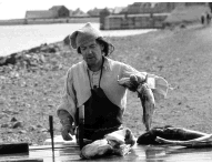
community, with a diverse and constantly shifting population which included Basques,
Irish, Acadians, Blacks, and Aboriginal people. There were also New Englanders in
and out of the town trading goods from the British colonies and elsewhere.
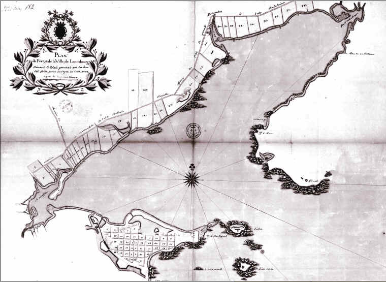
In addition to being a fishing and trading centre, Louisbourg also became the administrative centre for the colony of Ile Royale (Cape Breton Island), and the French military stronghold of Atlantic Canada. Louisbourg extended around the harbour far beyond the walls of the town's core, as fishermen staked claim to waterfront properties and merchants, tradesmen, and tavern-keepers followed them. With its walled inner city, and outlying defences such as the Island and Royal batteries, Louisbourg was among the most heavily defended settlements on the continent. It closely resembled a European fortified town [MAP 1].
In 1745, after three decades of peace and prosperity, a combined British and New England force attacked and captured Louisbourg. An occupying army took over the town, and its residents were removed to France. Three years later Britain returned Cape Breton to France through a treaty. In 1758 Britain took Louisbourg a second time, and in 1760 demolished much of the fortifications. In 1768, when the British garrison left, Louisbourg became, in the words of the Governor of Nova Scotia, a "decayed city ... going to ruin". Although English-speaking settlers trickled into the area subsequently and revived the fishery, the focus of settlement moved to the north side of the harbour. The former fortified town came to be known as "Old Town", and was "a place of scattered houses, grazing animals, and ruins". Interest in commemorating the historic significance of Louisbourg began at an early date. The French were the first. In 1720, they placed commemorative medals within the walls of certain buildings. Later, in 1767, Samuel Holland erected the first post-French commemorative monument, although it has since disappeared. In the latter half of the 19th century, however, interest grew in Canada and elsewhere in commemorating and preserving vestiges of the past. In 1895 an American organization, the Society of Colonial Wars, erected a monument at Louisbourg to mark the 150th anniversary of the 1745 siege. A number of Canadians began to take an interest in Louisbourg as a result of the erection of the 1895 monument. Senator Pascal Poirier expressed concern in the Senate that the area did not belong to either the Nova Scotian or Canadian government. Poirier visited the site in 1902, on behalf of the Royal Society of Canada and called on the government to preserve at least the remaining ruins. Over the next decade other individuals and organizations made proposals to mark the site's history. One individual was Captain D.J. Kennelly, an Irish-born industrialist who became general manager of the Sydney and Louisbourg Coal and Railway Company. In 1903 Kennelly began an international campaign under the auspices of the Louisbourg Memorial Fund. The society purchased the land with the most prominent ruins, raised money to have them stabilized, and in 1906 saw provincial legislation passed to declare Louisbourg an Historical Monument of the Dominion of Canada. Shortly after, J.S. McLennan, retired industrialist and publisher of the Sydney Post, began calling for the Canadian government to preserve Louisbourg. In an address to the Nova Scotia Historical Society, McLennan declared that preserving historic sites was too great a task for private or co-operative ventures, and that some of its significance would be lost except for "the action of the people through their governments." When the Historic Sites and Monuments Board of Canada (hsmbc) was created in 1919 to advise the Minister of the Interior on the preservation of historic sites of national significance, Louisbourg was one of the first sites it considered. The Board discussed Louisbourg frequently over the next two decades in close collaboration with Parks Branch officials. Initially the Board's focus was the protection of the ruins at Louisbourg, and then on their commemoration. In response to the Board's recommendations, the Parks Branch began acquiring land at Louisbourg in 1921. In 1923 the two Maritime members of the Board, Major J. Plimsoll Edwards and Dr. John Clarence Webster, were designated a special sub-committee to report on Louisbourg. They recommended to the Board that the entire site of historic Louisbourg be acquired, and that the fortifications be put in some sort of order. Throughout the period, the Board worked with people such as J.S. McLennan. This cooperation led, in 1926, to the unveiling of four bilingual commemorative plaques at the Lighthouse, the Dauphin Bastion, and the King's Bastion. In 1927, Henri Bourassa, prominent Quebec nationalist, journalist and politician, visited Louisbourg in the company of a large party of French-Canadians from Quebec and Ontario. Bourassa had visited Louisbourg thirty years earlier. Upset at the deterioration of the ruins over that time, Bourassa vowed to bring before Parliament the need to preserve historic Louisbourg. The following year he rose in the House of Commons to complain about "the terrible state of abandonment" of Louisbourg, and the need to clean up and protect the site. In the 1930s the Parks Branch started to plan for Louisbourg's future. Minutes of the hsmbc for May 1930 note the need for a comprehensive development scheme. This led to the appointment of a local sub-committee to advise the Board on Louisbourg. Senator McLennan and Melvin S. Huntington, Mayor of Louisbourg, were members. By this time the Parks Branch had acquired most of the private properties on the site of the former fortified town of Louisbourg. The hsmbc came up with recommendations for the excavation of selected building locations, and the reconstruction of the walls of the structures to a height of several feet. The hsmbc also looked at the issue of cultural resources under the waters of Louisbourg's harbour, and discussed the commemoration of cemeteries at Louisbourg, in co-operation with other organizations. And in 1936 the federal government opened a museum at the site, with Katharine McLennan, daughter of J.S. McLennan, as honorary curator. By 1940 the Parks Branch had acquired additional land, and Louisbourg became known officially as the Fortress of Louisbourg National Historic Park, following a campaign by Cape Breton historical enthusiast, Albert Almon. The Park then included the old townsite, Battery Island, and the Royal Battery. Eventually the Park came to include much of the area covered by the siege works erected in the assaults of 1745 and 1758. This ensured the protection of one of the best-preserved and most extensive 18th century siege landscapes in the Western World - an incomparable archaeological treasure. In 1961 the government of Canada accepted the recommendation of the Royal Commission on Coal, that there be a symbolic reconstruction of the fortress to provide employment, boost the tourism industry, and inspire the region culturally and intellectually. Two decades later nearly one-quarter of the walled heart of Louisbourg was reconstructed. The reconstruction is a tribute to J.S. McLennan, Pascal Poirier, and others who, inspired by the Site's place in history, called for its commemoration. At the same time, Fortress Louisbourg has become a symbol for the whole country, a testament to the skills and dedication of those who called for its protection, an assertion of Canada's identity, and a legacy to the nation. It is a tribute to the confidence with which Canadians celebrated the completion of Canada's first century, an acknowledgement of the past, and an act of faith in the future. 1.2 COMMEMORATIVE INTEGRITY One of Parks Canada's fundamental objectives for the National Historic Sites Program is to ensure the commemorative integrity of national historic sites administered by Parks Canada by protecting and presenting these places to the Canadian public in a manner that respects their significant and irreplaceable legacy. The goal of management planning for national historic sites is to ensure commemorative integrity and the application of cultural resource management principles and practices. Commemorative integrity is a way of describing the health or wholeness of a national historic site. A national historic site possesses commemorative integrity when:
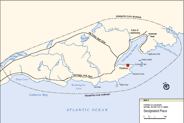
The following is an abridged version of the approved Commemorative Integrity Statement. The reasons for the national historic significance of Fortress Louisbourg - The Statement of Commemorative Intent A Statement of Commemorative Intent states the reasons for the site's national significance as determined by the Historic Sites and Monuments Board of Canada (hsmbc) and approved by the Minister. Fortress of Louisbourg has unusual quantity and diversity in its cultural resources. The development of Louisbourg as a military fortified town, as a colonial trading centre oriented to the sea, and as a cosmopolitan capital of French possessions on the east coast has left a wealth of archaeological resources for posterity. In addition to the archaeological resources of the former town, there are hundreds of known archaeological sites outside the walls associated with French military, domestic and commercial activity, and with the military sieges of 1745 and 1758. The Site's ability to evoke powerful images of the past through cultural resources and landscapes has remained largely uncompromised. There are a number of 18th century documented shipwrecks in the harbour and beyond. Those in the harbour were sunk in the course of the 1758 siege. Although outside the Site's boundaries, the wrecks relate directly to the national significance of the Site and contribute valuable information on Louisbourg's marine and naval history. The hsmbc met on several occasions to discuss Louisbourg and its need for protection and commemoration, particularly during the 1920s and 1930s. Their deliberations largely focused on the military importance of the Site, and the need to ensure protection for the ruins. Their interest is reflected in the early commemorations they recommended to the Minister of the day such as the Dauphin Bastion, Wolfe's Landing and the King's Bastion. In 1928, when Fortress of Louisbourg was designated a National Historic Site, there were no recorded deliberations indicating their intent for the commemoration. Later in the 1970s, the hsmbc approved a plaque inscription that was more encompassing of the general history of the Site. The plaque is located outside the visitor reception centre. Thus, there is no single recommendation from the Board that conveys its intent in recommending that Louisbourg be commemorated. The Board's intent may be inferred, however, from the overall record of its deliberations, especially in the early years when commemoration was first being discussed. There is a focus on the Anglo-French military history of the Site and the ruins that reflected that history. All of the above information has helped to prepare a Statement of Commemorative Intent that reflects the national significance of the Site and that in turn provides the basis for the nationally significant messages that are to be conveyed to visitors and the public: Fortress of Louisbourg is of national historic significance because, between 1713 and 1768, it was a place of profound significance in the great Franco-British struggle for empire. Fundamental to its role in this struggle was that Louisbourg, besieged and captured in 1745 and 1758, was the capital of the colony of Ile Royale, a critically important French fortification, and the most significant French fishing centre and commercial entrepot in North America. PART ONE The resources that symbolize or represent the Site's national historic significance are not impaired or under threat The resources of national historic significance symbolize and represent the importance of Louisbourg. They are Level 1 cultural resources under the Cultural Resource Management Policy, by virtue of their association with Louisbourg's commemorative intent. a) Designated Place Designated Place is defined as the place designated by the Board, irrespective of current ownerships or jurisdictional boundaries. Designated Place can then be larger or smaller than the current boundaries of the national historic site. Within the context of the Board's commemorative intent, most of the Designated Place is found within the current boundaries of the Site. The general areas that are missing include part of the modern town of Louisbourg that would complete the contiguous land area of Designated Place from west to east around the harbour, and the harbour itself. Designated Place would include the coastal and immediate hinterland areas as defined on the map titled Designated Place [MAP 2].
Designated Place cannot be fully understood without reference to Fortress Louisbourg's local and regional context and significance. Militarily, the fortified town guarded the approaches to the Gulf of St. Lawrence, the main shipping route to Quebec and the interior of the country. Sited on land ceded to the French by the Treaty of Utrecht (1713), the fortified town counteracted the growing British influence on mainland Nova Scotia, an area lost to the French by the same treaty. The fortified town also helped to protect the lucrative fisheries and the off-shore trade, the economic foundation of Louisbourg and of vital importance to France. Locally, the harbour was a critical factor in siting the fortified town. The harbour offered protection from the open Atlantic, was ice-free year-round, and was close to the rich fishing grounds where cod abounded. The French also made Louisbourg their administrative centre and capital for their possessions on the east coast (Cape Breton Island and Prince Edward Island). Designated Place includes those lands and waters associated with the French and English presence at Louisbourg from 1713 to 1768. Within these areas there was significant military and civilian activity. The military activity encompassed both army and naval actions, and the civilian activity included both commercial and domestic activity. The Designated Place extends in the west from the Deep Cove area eastward past Kennington Cove including coastal and inland areas to Louisbourg harbour and then continuing on past Lighthouse Point and Gun Landing Cove to Lorraine Head. Archaeological evidence of these activities abounds throughout this area. The evidence includes the fortified town itself with the remains of hundreds of buildings, structures, streets, quays, fortifications, walls, etc. The town spilled out beyond the fortifications to include the area known as the Fauxbourg (shoreline area outside the Dauphin Gate) and the north shore (toward the modern town of Louisbourg), where fishing properties, storehouses and taverns flourished linked by a number of roads. It was in this latter area that the French built the Royal Battery, a major satellite fortification protecting the harbour from attack. Designated Place continues around the harbour to include the eastern side where ship repair facilities were constructed at Careening Cove and Canada's first lighthouse was built. Designated Place also encompasses the large area where military and naval activity occurred to defend and attack Louisbourg. It includes major landing points to the west and east of the fortified town such as Kennington Cove and Gun Landing Cove, French coastal defensive works, eg., earthworks, such as at Kennington Cove and Flat Point, and all the British siege works associated with the attacks of 1745 and 1758 including encampments, roads, batteries, siege works, outposts, etc. Looked at together, these cultural resources comprise an impressive 18th century battlefield site, unparalleled in Canada. Louisbourg's harbour is very much a part of Designated Place given the naval activity that occurred there during the sieges and because of the number of shipwrecks from the 1758 siege specifically. As well, Battery Island, located in the mouth of the harbour, played an important role in the defence of the harbour from naval attack. Viewplanes around the harbour and seaward were critical for defensive purposes. The fortified town, Royal Battery, Battery Island and other batteries together offered excellent protection from an enemy naval force advancing into the harbour. Landward, viewplanes from the fortified town toward key locations, such as the Plain of Gabarus and the North Shore, were also important to defend against attacks. The area around the Fortress was much different in the 18th century than it is today. Essentially, the landscape was cleared of trees for kilometres around the Fortress as a result of military reasons - line of sight and fire - and need for construction materials and firewood. Historic Values The historic values of the place reside in the attributes of the surviving Level 1 cultural resources and in their associations with Louisbourg in the period 1713 to 1768. Most notably, these Level 1 cultural resources consist of:
The historic values of the Designated Place reside in its association with Louisbourg's role as:
And for its association with:
Objectives The Designated Place will be safeguarded when:
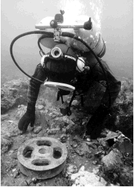
b) In-situ Archaeological Resources (1713-1768) These consist of terrestrial and underwater
sites located within and beyond the reconstructed townsite, including underwater sites
within and beyond the harbour. Terrestrial sites include the remains of military and
civil structures in the townsite and outside. Underwater sites consist primarily of shipwrecks.
Historic Values
Heritage Values These values, although important, do not relate to commemorative intent.
Objectives (Integrity objectives relate only to historic values, and not to heritage values.) Threats to in-situ terrestrial and underwater archaeological resources will be mitigated and resources safeguarded when:
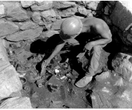
c) Archaeological Collections (1713-1768) Louisbourg's artifact collection is a time capsule from the 18th century, an historical record of a major 18th century community. About 98% of the items in the collection of 5 million artifacts are from the commemorated period and consist of ceramics, glass, metals, building materials, and small finds. Historic Values The collections have historic value:
Objectives The archaeological collections will be unimpaired or not under threat when:
d) Curatorial Collections (objects from 1713-1768) About one-half of the items in the McLennan and Almon collections are from the commemorated period. Objects include such items as an armoire, a painting and some surface finds. Historic Values The Level 1 objects in the curatorial collections have historic value for:
Objectives The Level 1 objects in the curatorial collections will be unimpaired or not under threat when:
e) Landscapes (1713-1768) The landscape of the National Historic Site contains many cultural resources surviving from the commemorated period. This overall landscape can be usefully subdivided into separate cultural landscapes. This section begins to describe those from the commemorated period. It should be noted that the Level 1 built, archaeological and moveable resources they include have mainly been previously identified. This section concentrates on the identification of key cultural resources and surviving landscape elements. Battlefield Sites The siege works, encampments, and defensive installations that have survived from the 1713-1768 period have been described as among the largest extant grouping of 18th century battlefield sites in the world and are unique and valuable resources that must be protected. Hundreds of works were built in the two sieges, including redoubts, earthworks, encampments, redans, batteries, and blockhouses. The encampments provided lodging, storage and medical facilities for thousands of men and hundreds of women. Viewplanes are important components of these landscapes, as are the vestiges of siege works, encampments and defensive works. These works are mostly buried, and in some cases they have been reclaimed by the forest, but there are many visible walls and foundations. The erection of these works in the 18th century involved, in some instances, major changes in the natural landscape, as it was shaped to meet military need. The cultural resources in some cases define the character of the landscapes. Outstanding examples of this are Lime Kiln Hill and the Hill of Justice, outside the walls of the fortified town. The siege landscapes also include a number of natural features which are largely unchanged from the period of commemoration, such as Freshwater Brook and Wolfe's Lookout. Unreconstructed portions of the townsite, the North Shore, Fauxbourg, lighthouse area, Rochefort Point, the hinterland These landscapes extended beyond the walled heart of Louisbourg in several directions. In one direction, they stretched out to Rochefort Point. They also extended around the harbour to the lighthouse, and into the hinterland. They encompassed much domestic activity. The Fauxbourg and the North Shore were particularly important suburbs of Louisbourg. The Fauxbourg, on the shoreline just outside the Dauphin Gate of the Fortress, was destroyed in the 1745 siege, rebuilt when the French regained possession of Louisbourg in 1748, and destroyed again in the 1758 siege. Those elements of these landscapes which have survived from the 1713-1768 period are Level 1 resources. In the case of the unreconstructed portions of the walled townsite, the landscape vestiges include extensive, visible evidence of foundations, and walls of structures erected in the period of commemoration. These areas also contain evidence of the destruction of Louisbourg in 1760. The ruins of the walled town define the landscape, a relic of the period of commemoration. Another landscape which is a relic of the commemorated period is that of Big Lorraine, at the east end of the Site. Big Lorraine was a French fishing community which is probably the only largely undisturbed site of a satellite community from the 1713-68 period. Lighthouse Point is an essentially unmodified landscape from the period of commemoration. Cemeteries, Roads and Trails These landscapes represent particular functions (burials and transportation routes), which began in the period of commemoration and continued beyond it, in some cases to the present day. There are eleven cemeteries within the Site, and miscellaneous burials at eight other locations. Eight of the eleven cemeteries contain burials from the 1713-1768 period, and thus relate to commemorative intent. Of these cemeteries the Rochefort Point cemetery is the largest. It contained at least several hundred burials, and possibly as many as 1,000. Some of the roads at Louisbourg, such as the "Old French Road" - the road to Grand Lake and the Mira River - were built in the French regime, and thus relate to commemorative intent. Another is former Route 22, which follows an alignment of the road constructed by the French in the 18th century. Sections of the Kennington Cove Road date back to the siege of 1745. The 1713-1768 components of these roads are Level 1 cultural resources. Historic Values The historic values of Louisbourg's landscapes reside in the surviving physical attributes and in their associations with Louisbourg as it was between 1713 and 1768. They include:
Objectives The landscapes will be safeguarded when:
PART TWO Messages about the site's national historic significance are effectively communicated to the public. The second component of commemorative integrity relates to presentation. The Statement of Commemorative Intent for Louisbourg captures what is nationally significant about the Site. Level 1 messages relate directly to the Statement of Commemorative Intent and hence to the national significance of the Site. The Level 1 message that should be conveyed to the public is:
To achieve an understanding of the national significance of the site, one needs to grasp the underlying importance of the messages as elaborated below: The Fortified Port: From its establishment by the French in 1713 until the withdrawal of the last British troops in 1768, Louisbourg played an important role in the Anglo-French struggle for control of North America. In 1745 a New England army, supported by a British naval squadron, captured Louisbourg after a 46-day siege. France regained the town by treaty in 1748, but lost it to the British again in 1758. Its fall opened the way for the British conquest of the rest of New France.
The Capital: As capital of the colony of Ile Royale, Louisbourg was a cosmopolitan, relatively sophisticated colonial community, with an official class responsible for administering the fisheries, trade, relations with the Native allies of the French, and the French military establishment. Although Louisbourg was part of New France, Louisbourg society differed from that of the French communities along the St. Lawrence. There was no seigneurial regime, the fur trade was negligible, the institutional power of the church was minimal, and numbers of non-French peoples lived and worked alongside the French majority.
The Fishing Centre and Commercial Entrepot: The cod fishery of the North Atlantic was more valuable to France than the fur trade of the interior of North America. The cod fishery as the cornerstone of Louisbourg's economy allowed it to quickly develop into an important trading centre, visited by vessels from France, the West Indies, Canada, New England and Acadia.
Objectives The national historic significance of the Site will be communicated to the public when:
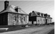
PART THREE The Site's heritage values are respected in all decisions and actions affecting the Site. While the primary value of Fortress of Louisbourg National Historic Site of Canada lies in its commemorative intent, and those resources that reflect commemorative intent, the Site also encompasses extensive Level 2 cultural resources and other resources which impart value to the Site. Level 2 Resources and Historic Values Museum building and caretaker's house These structures are designated Classified heritage buildings by the Federal Heritage Buildings Review Office (FHBRO). They have historic value in that:
Commemorative integrity of these structures will be achieved when:
Curatorial Collections About 40% of the objects are non-site-specific objects from the commemorated period, are original objects from later in the 18th or 19th century, or are 19th century reproductions. Objects include paintings, tapestries, and furniture. They are contemporary with or represent a continuation of traditions of the 18th century. They have historic value for:
Commemorative integrity of the collections will be achieved when:
Archaeological Collection About 2% of the total collection is from the post-1768 community that developed on the ruins of the old town of Louisbourg. The collection includes tableware, glassware, ceramics and hardware. They have historic value for:
Commemorative integrity of the collections will be achieved when:
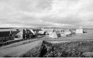
In-Situ Archaeological Resources These include 19th and 20th century archaeological sites such as "Old Town", the Marconi site, farmsteads, World War I and II installations. They have historic value for:
Commemorative integrity of these archaeological resources will be assured when:
Lighthouse This is a FHBRO-Recognized heritage building administered by the Department of Fisheries and Oceans. It has historic value in that:
Commemorative integrity of this resource will be assured when:
Landscapes Louisbourg has a number of Level 2 cultural landscapes from the 19th and 20th centuries such as at Rochefort Point and Kennington Cove. They have historic value in that:
Commemorative integrity of these landscapes will be assured when:
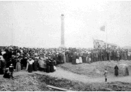
Monuments Monuments and plaques such as the 1895 memorial erected by the Society of Colonial Wars have value because:
Commemorative integrity of the monuments will be achieved when:
Cemeteries (post 1768) There are three cemeteries from this period. They have historic value in that:
Commemorative integrity of the cemeteries will be achieved when:
Level 2 Messages These messages communicate heritage values associated with Fortress of Louisbourg National Historic Site of Canada. They are of secondary importance, and are not linked to the commemorative intent of the Site.
Values of Other Resources Natural Resources They have value:
Reproduction Curatorial Objects Collection The collection has value for:
Library/Archives This institution has value for:
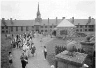
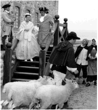
The Reconstructed Townsite The reconstructed townsite has value:
|