|
3.0
Strategic Direction for Commemorative Integrity, 3.3 Heritage Protection A. Archaeological Resources Terrestrial Fortress Louisbourg is an extraordinary place. The Site encompasses the ruins of an entire 18th century fortified town, its suburbs, its outlying fortifications and lighthouse, roads connecting to neighbouring settlements, fishing establishments, and impressive remains of two military sieges. The value of these cultural resources is not limited to their size and scope. Perhaps their strongest asset is their sense of place and ability to communicate the passage of time. Fortunately, most of Fortress Louisbourg's archaeological sites lie at the surface. Visitors can easily see the ruins of the Royal Battery, various buildings, earthworks and bomb craters. They all leave a powerful image, one that clearly shows the massive scale of the French constructions and of the final siege of Louisbourg. As rare as it is to have substantial ruins, it is equally rare to see such intact archaeological sites in their original setting. Many colonial sites are now located in modern urban centres. A visitor to Fortress Louisbourg is fortunate to be able to experience the archaeological sites along with a wonderful sense of place, one that is remarkably similar to that of the 18th century. Nature of the Archaeological Resources
Most of Fortress Louisbourg's archaeological resources come from two sources. The establishment of a French fortified town with a thriving fishing and trade economy, and its defence. The other is the British presence through two sieges and subsequent occupations [MAP 4].
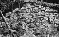
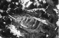
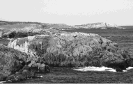
Louisbourg harbour was first intensely settled by the French in 1713. The French had been forced to move their base for the north Atlantic fishery from Newfoundland to Cape Breton Island and Prince Edward Island. When Louisbourg became the colony's capital, the royal engineers laid out a plan with rectilinear town blocks and wide streets leading to and from the quay surrounded by fortifications. The implementation of the town plan had a profound effect on the landscape. The French excavated the large ditch encircling the landward face of the town, built the bank or glacis along the town's edge, levelled hills, blasted bedrock outcrops, and reconfigured two large ponds through in-filling. The town was further shaped by being the administrative centre that needed capital investment in public buildings, roads, wharves, fortifications, and lighthouse. The town's flourishing economy provided the capital for the construction of many private homes and businesses, and nourished a confidence in the town that led to improvements and expansion, and the return of the French in 1749 after the first siege. This level of activity was not limited to the townsite. By 1734, 44% of the town's population lived beyond its walls along the shore in the shelter of the harbour. Here they built fishing establishments consisting of homes, storehouses, staging, wharves, and gardens. Other properties included taverns, a butchery, an early governor's residence, and an area for ship repair or careening. In addition to the thriving commercial ventures, two major elements of the fortifications were built outside of the town. The Island Battery was constructed on an island in the mouth of the harbour. The Royal Battery on the north shore guarded the harbour entrance and channel. The walled town, its suburbs and satellite communities were linked by roads, some of which are still in use today. Former route 22, the compound service road and parts of the Kennington Cove road were built during the French regime as was the Old French Road, now used as a walking trail. As remarkable as the French remains are, Fortress Louisbourg's archaeological resources also include extensive remains of the British presence. The second siege in particular left a profound mark on the landscape and a wealth of archaeological resources. The artillery "train", 13,000 troops, and all logistical support occupied an area that stretched from the coast near Kennington Cove in an arc to what is now the administrative and maintenance compound area. Each regimental camp housed 1000 or more soldiers in huts and tents and provided all shed, sentry posts, entrenchments, ovens, and latrines. Additional quarters and positions were established near what is now the visitor reception centre and the lighthouse. Offensive works were also built including blockhouses, redoubts, redans, batteries and roads. After the siege and the withdrawal of the garrison in 1768 these works were dismantled or abandoned.
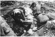
By the early 1770s the town population consisted of some 33 families, headed mostly by disbanded British soldiers. This change from an urban centre to an essentially rural one happened within a few years. Those who stayed or came were dependent on subsistence living based on the fishery and farming. This trend carried on for generations with slow growth and settlement. Over time, much of the population shifted to the north shore of the harbour toward the modern community of Louisbourg, although some settlement remained at Kennington Cove and along the main roads. Twentieth century interest in site protection culminating in the establishment of the National Historic Site led to the final impacts on settlement patterns and use. Status of Cultural Resources Inventory To date there are 466 Level 1 and 452 Level 2 in-situ resources inventoried outside the walls of the fortified town. Much of the Site has not been surveyed or examined in detail. Most areas that have been surveyed have received only a baseline survey. During the reconstruction phase, archaeological research focussed on the salvage excavation of the areas of the town chosen for reconstruction. Some selected areas outside of the fortified townsite were surveyed and excavated but work focussed on particular features and time periods. During the 1980s a baseline survey was undertaken in the Fauxbourg, the north shore, Kennington Cove, the siege works along Freshwater Brook and at the Lighthouse, and a few additional outlying areas. The survey located and identified some 800 cultural resource sites. It amassed a large data base of historical and archaeological information, now accessible through electronic data bases. Comprehensive surveys outside of the fortified town have been undertaken for areas impacted by specific developments such as the upgrading of route 22 and the installation of the new waterline. The only comprehensive surveys undertaken for cultural resource purposes have been the recording of the Royal Battery prior to the construction of the protective seawall, the testing and salvage excavation of sites eroding along the north shore, and the testing and survey of Rochefort Point.
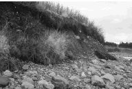
Since the 1980s Global Positioning Systems (GPS) has improved survey work locational technology. GPS has demonstrated that former practices of baseline survey work (using map and compass) are not precise enough for impact assessments and environmental screenings. Recent experiences with the Fleur-de-lis Trail and waterline replacement substantiate this. The lack of sub-surface testing and of models of particular kinds of sites such as the siege works leaves staff unable to assess adequately and efficiently the impact of developments and in some cases to monitor, identify and assess threats properly. The townsite has two inventory problems. The area not reconstructed or 75% of the townsite has never been surveyed. The only exception is the hospital and a small area of the town ruins. Within the reconstructed townsite, significant portions of properties especially the yards, and parts of the streets, were not excavated. Although detailed records on the excavations are available, consistently accurate records on features such as paved walkways, wells, foundations etc. that were left in place are unavailable. Further, few records were kept of the impact of the construction on the remaining archaeological fabric. Threats Vegetation - Most archaeological sites outside of the townsite are now covered by forest. Generally, this was not the case prior to Parks Canada assuming ownership of the land in the 1960s. As a result, many of the siege positions are threatened by tree growth and windfalls that can destroy stratigraphic relationships and damage the ruins of masonry features. A multi-year project has been initiated to address the problems posed by vegetation to the siege sites and to gather more precise locational information for these features. In the mid-1980s Site staff stopped burning the fields in and around the townsite, and limited the amount of brush cutting and mowing. As a result much of the landscape and many of the archaeological sites are now covered with alders. The impact of woody plants on an archaeological site that for the most part exists at or near the surface is profound. The vegetation control techniques recommended by the siege site conservation project will also be applied to those sites in the town, its suburbs and nearby fields. Erosion and Rising Sea-Level - Fortress Louisbourg's coastline consists of bedrock, till cliffs, cobble and sand beaches. Aerial photo analysis shows that 7 metres have eroded from locations on Rochefort Point and the North Shore since 1950. Current tide levels are 80 centimetres higher than 18th century datum. Studies suggest land subsidence is 30 centimetres per century along this coast. This trend will continue.
The rising sea level and continued erosion of the shoreline threaten archaeological resources lying close to the coast, as well as the reconstructed townsite itself. There is a need for a comprehensive plan for the protection of these resources. The Geological Survey of Canada is undertaking a study of the geology of the harbour and its adjacent coastline. The study has three phases; the first two include shoreline and marine surveys. The third involves engineering and modelling components, including the modelling of marine processes, and the development of a shore protection plan that will recommend strategies and actions for the protection of threatened archaeological resources. Working Ruins and Recycled Artifacts - Within the reconstructed townsite there are a number of in-situ cultural resources that are exposed as exhibits or that have been incorporated into the reconstructed buildings or structures or landscape components. Examples of exhibits are the Loppinot and Fizel house ruins. The sites were excavated and the surviving masonry stabilized. Both have interpretive panels and function as an outdoor exhibit. In other areas buildings were built on original foundations. The De la Valličre storehouse includes an original stone paved floor and the base of the original masonry foundation and footings. The counterscarp wall of the Dauphin/Kings Bastion outer works is also built on the surviving original wall. Extant original structures that are currently exposed are the postern tunnel and the counter-mine tunnel in the King's Bastion. Projects have been initiated to address the conservation of the resources that are in poor condition particularly the Postern Tunnel and outer defences, but these projects have not yet determined the appropriate solutions or interventions. Development - Since the 1960s development has included a variety of visitor, operational and administrative facilities and services. These include construction of trails, roads, parking lots, buildings, services, outdoor exhibits, etc. Environmental assessments are essential to preventing and mitigating impacts on cultural resources. Much of the solution in future lies in good cultural resource management: inventory, evaluation, recognition of historic value, monitoring and visitor appreciation of the values. The long-term objective is to ensure that the archaeological resources are in good condition. Surveys, assessments, mitigation and conservation efforts will continue where needed to address threats, upgrade the condition of resources, and ensure these resources are properly recorded and protected. Changes in the condition of archaeological and built resources will be reported through the State of the Parks Report. Strategic Actions
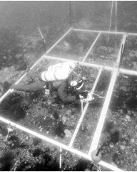
Underwater There are significant underwater cultural resources within and adjacent to the Fortress of Louisbourg National Historic Site of Canada. In 1996, the Historic Sites and Monuments Board of Canada recommended the shipwrecks and other submerged resources dating from the 18th century in and around the harbour to be of national significance. The ones that have received the most attention are the remains of ships that were sunk in the harbour in the second siege in 1758. These ships, of which there are nine, are outside the boundaries of the National Historic Site, but Fortress staff are active participants in the protection and management of these cultural resources. There are at least 26 documented sunken ships from the period 1713-1758 in the harbour and adjacent areas of the ocean. The ships in and around the harbour relate directly to the commemorative intent of the Site. They are Level 1 cultural resources, even though they are outside the Site's boundaries. Within the Site's boundaries, there are also known cultural resources in the ponds on the west and east sides of the reconstructed townsite. The lakes and streams, of which there are many, have yet to be examined.
Five harbour surveys of underwater cultural resources have been carried out since the 1960s. These surveys were designed to locate, inventory, and evaluate major underwater cultural resources related to 18th century Louisbourg. The information has proven helpful in managing the resources and will be important in their future presentation. Access to the cultural resources within the harbour is controlled by the federal Department of Transport through the Harbour Master. A permit issued by the Harbour Master is required to dive in the harbour for any reason. In cooperation with the Harbour Master, the Site's dive team monitors the ships and diving activity. Individuals who are searching for archaeological materials are also required to have provincial permits. The Special Places Protection Act requires individuals to obtain a Heritage Research Permit from the Nova Scotia Museum. In addition, the Treasure Trove Act requires individuals searching for treasure to have a Treasure Trove Licence, issued by the Nova Scotia Department of Natural Resources. Parks Canada also requires a permit for individuals who are searching for archaeological resources for which the Department of Canadian Heritage acts as the agent for the Crown. Parks Canada has acted in this role since the 1960s for the sunken ships in the harbour. Until quite recently the government of France has claimed an interest in French ships sunk at Louisbourg. The French government has now confirmed federal crown jurisdiction by ceding its interests in French ships sunk prior to 1763. During the last two decades there has been a rise in the popularity of eco-tourism and the development of marine or dive parks. Staff have successfully helped to protect known resources in the harbour and are just beginning to interpret them for the diving visitor. These resources could provide dramatic and interesting vehicles for interpreting the marine and naval history of Louisbourg. Joint ventures with tour companies or film/video production houses could also provide a source of revenue. While ships sunk in and around the harbour have attracted more attention than other underwater cultural resources, there is a need to investigate the ponds at the western and eastern end of the fortified town. The eastern pond is threatened by coastal erosion where the barrier beach has been breached in severe storms. Strategic Actions
B. Cultural Landscapes Although definitions vary, there is an emerging view that cultural landscapes consist of three categories:
Fortress Louisbourg has examples of each of these categories and they exist in an unusual degree of preservation. The construction of the large fortified town created the most obvious example of a cultural landscape. Today, Louisbourg exists partly as a reconstruction, but most of the historic townsite still exists as a relict designed landscape, with the block plan, military outworks and building foundations still visible. This landscape is a Level 1 cultural resource. The French also settled in other locations at Louisbourg, most notably along the north shore of the harbour. Surviving features around the harbour from the French period include Island Battery, Royal Battery, the lighthouse site, and ship repair facilities at Careening Point. These are all Level 1 cultural resources. In some cases they exist in combination with features from later periods, and constitute, as in the case of Lighthouse Point, an evolved relict landscape. There are also significant viewplanes within the cultural landscapes like those from the reconstructed townsite to Lighthouse Point and the north shore. The French occupation resulted in major
impacts on the natural environment. Indigenous forests were cut for several kilometres
around the town for firewood and building materials. As a result, original tree
species such as red spruce, white pine, and yellow birch are largely absent today, having
been replaced by a forest cover of white spruce, black spruce, and balsam fir. At the
same time, significant natural features such as Freshwater Brook and Wolfe's Lookout
have survived from the period of commemoration.
In
some cases, the regenerated forest has obstructed viewplanes that were
significant in the 18th century.
There are also archaeological sites associated with the two sieges of
Louisbourg. The surviving sites are valuable in their complexity and
completeness of 18th century siege techniques. The settlement pattern that developed after the French period is
distinctly different from the French pattern. It began with the withdrawal
of the last of the British garrison in 1768, and the settlement of
discharged soldiers and emigrants within the French ruins and along the
north shore of Louisbourg harbour. This pattern slowly evolved throughout
the 19th and early 20th centuries. There is a need to integrate the
protection and presentation of cultural landscapes into management
decision-making. The concept of cultural landscapes offers an integrative
approach to the management of cultural resources. Rather than considering
resources individually, emphasis is placed on defining the larger
settlement imprint. Louisbourg has considerable potential for the
identification, protection, and interpretation of cultural landscapes.
Successive settlement patterns are readily discernable, and further study
may result in the identification of Level 2 landscapes in relation to
post-1768 settlement in areas such as Kennington Cove or in association
with the Marconi station. It should be recognized that Louisbourg consists mainly of relict
landscapes. There is no need to recreate 18th century landscapes. It
should also be recognized that there is the potential for cooperative
efforts to protect and interpret landscapes in and near Fortress
Louisbourg, such as the harbour and its environs, and the continuation of
the Old French Road beyond the Site boundaries. Strategic Actions
C. Museum, Caretaker's House and Lighthouse The Canadian government built the museum and caretaker's house in 1935-36. The two structures are representative of an era in which similar buildings were erected in other national historic sites to present and commemorate Canadian history. The two buildings are storey-and-a-half, stone-faced, copper-roofed structures whose major elaboration consists of prominent gabled entries and dormers set into their hipped roofs. The museum is joined to the caretaker's residence by a small walled courtyard. The design is evocative of French colonial architecture of the Baroque era. Inside, the museum is organized as two large open spaces at basement and ground floor levels. The museum is closely associated with J. S. McLennan and his daughter, Katharine McLennan. J.S. McLennan's personal collection of research materials and artifacts formed the core of the museum's collection for its first 25 years. Katharine McLennan was named honorary curator of the museum in 1935, and remained in charge until the 1960s. The museum still houses exhibits illustrating the history of Louisbourg including her large model of the fortified town as well as her father's collection. The museum and house are across from the Governor's Garden, at the edge of the reconstructed townsite. The site immediately around the buildings has changed very little since their construction. These 1930s structures are sympathetic to the reconstructed townsite, and fit comfortably within the landscape. The Federal Heritage Buildings Review Office has designated these structures as classified heritage buildings. As a result, the buildings are Level 2 cultural resources and will be managed accordingly.
The current lighthouse is the third to grace Lighthouse Point marking Louisbourg's long and rich maritime history. It was constructed in 1923 close to the ruins of the former two lighthouses. The lighthouse represents a continuity of function at this location since the 18th century. It is administered by the federal Department of Fisheries and Oceans. The Federal Heritage Buildings Review Office evaluated the structure and designated it as a recognized heritage building. The defining heritage characteristics that led to the designation should be protected. Because the lighthouse is located within the National Historic Site, Parks Canada has an interest in seeing the heritage character of the structure preserved. Strategic Actions
D. Archaeological Collection
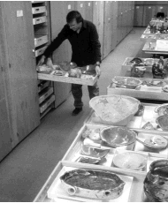
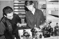
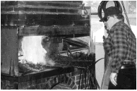
The archaeological collection consists of two components: the artifacts recovered during 35 years of an archaeological program at the Site, and the records, reports and notes generated by excavation, analysis and collections or resource management. The artifact collection, consisting of approximately 5 million items, includes a wide variety of materials with diverse storage and conservation requirements. The vast majority of the artifacts date from between 1713 and 1768, except for some which were deposited during subsequent settlement. Two types of storage systems are used to house the collection. The first is an open area storage allowing for easy access to the material. It ensures that efficient use is made of a researcher's time, and affords a safer environment for those artifacts which are unique or have received conservation treatments. The open storage segment of the artifact collection has been consolidated in one of the buildings in the maintenance compound. The storage area is heated and monitored for humidity to ensure that a stable environment is maintained. The artifacts stored here consist of all the ceramics, glass, treated or priority metals, some building materials and small finds. The second system is dormant storage. It is used for that portion of the collection that is referred to infrequently. It also includes oversize pieces. There are three classes of material in dormant storage: dressed building stones, nails, and faunal remains. This collection is not consolidated and is found in different buildings in the reconstructed townsite and in the compound. These storage areas do not offer stable environments. The records collection includes three categories of materials: those generated in the field during excavations, those derived from the analysis of fieldwork or artifacts, and those needed to manage the collection itself and the in-situ archaeological sites. The largest part of the collection consists of paper records, including field note books, survey books, research notes, maps, drawings, and photographs. Two major databases are also maintained for managing the in-situ resources. Excavations in support of the reconstruction at Louisbourg examined approximately 30 per cent of the fortifications, about 20 percent of the townsite and a small portion of the outlying suburban properties. The excavation of the military component of Louisbourg has extensively sampled all the major types of defensive features. The extensive offensive features have not been sampled. Excavations of the townsite and suburban properties examined public structures, homes, gardens, storehouses, taverns, kilns, bakeries, forges, streets, walks, and fences.
Given that there was little use of the townsite after the 1760s, the archaeological record is rich in material remains from the period 1713-1768 and has produced very little material from the end of the 18th century and later. At least 98 percent of the collection is tied to the commemorative intent of the Site and is a Level 1 resource. The remaining 2 percent are considered Level 2 cultural resources primarily because of their association with the evolution of the Site. The Level 1 collection is a uniquely valuable resource, with artifacts from over 50 separate but related properties, most of them completely excavated. And it is the only collection that is backed up by a major historical research program that sets many of the archaeological materials in their appropriate social, economic, functional and chronological contexts. The collection is an unparalleled resource for study and research purposes, but its potential has barely been tapped. The only area that has been systematically studied is the fortifications. However, archaeology of the townsite has the potential to produce dozens of comprehensive works. The material culture of the fishery, heating and lighting, sanitation and hygiene are only a few examples of topics that could be addressed. The collection has always been accessible to outside researchers. Portions of the collection have also been placed on loan temporarily to various museums and universities and are used in the exhibit program. Most of these items are in the Typological exhibit, which is for the most part 20 years old. These exhibit materials are essentially the type collections and are the ones researchers are most interested in. To improve on the accessibility of the collection, efforts are currently under way to access and inventory the entire collection, to store the originals in archival materials and proper storage environments, and to produce working copies of the records in an accessible medium, which for most will be a computerized format. There have been many positive changes made to the organization, accessibility and security of the collection over the last fifteen years, yet there remain a number of problems, including: 1. the conservation treatment and the upgrading of the storage of the priority iron artifacts, small finds and oversize wooden artifacts. 2. the storage area in the Barracks attic, as it does not meet the minimal level of storage standards for the faunal and other material kept there. 3. the lack of collection maintenance and disaster plans.
Strategic Actions
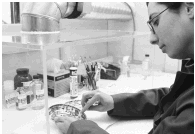
E. Curatorial Collections The curatorial collections contain more than 14,500 objects. The objects are extremely diverse, ranging from pewter spoons to the cannon on the walls. The collections include historic objects from the period of the commemoration, historic objects reproduced in the 19th and early 20th centuries, modern reproductions and modern interpretive pieces. The collection was acquired from the mid 1960s to the early 1980s to meet the requirements for use and display in animation, period rooms, and exhibits.
In addition, there are the McLennan and Almon collections. The former collection consists of approximately 350 pieces gathered by J.S. and Katharine McLennan for the museum, but includes additions made between the late 1930s and the start of the reconstruction project. The Almon collection consists of approximately 120 pieces donated in 1945 by Albert Almon.
A preliminary evaluation of the collections has been undertaken. About 40% of the individual pieces in the McLennan and Almon collections reflect the Site's commemorative intent and are classified as Level 1. These pieces include early surface finds. The McLennan and Almon collections are both considered Level 2 cultural resources, primarily because of their distinctiveness as a group of objects obtained by the Site. About 30% of the main collection consists of historic objects of the period of commemoration, or are 19th or early 20th century reproductions. These are Level 2 cultural resources because they are either typical of or contemporary with Fortress Louisbourg, or they represent a continuation of the traditions of the 18th century. Modern reproductions constitute the remainder of the collection. There is a need to improve record keeping of the collection. This is a result of years of demands being placed on the Site's curatorial unit as a result of the size of the reconstruction project and the growth of the animation program. Currently, about 70 percent of the objects in the collections are fully catalogued, while 30 percent are registered or are incompletely catalogued. Dossier files containing historical information on the objects' relevance and authenticity were only established several years ago. At present, some 85% of the dossiers are inadequate for research and interpretive purposes. A multi-year project addressing the backlog of unregistered items has just been completed, and a similar effort is planned for the backlog of incompletely catalogued objects and incomplete dossiers. The collections are widely dispersed within the reconstructed townsite, the compound, and the visitor reception centre. This creates difficulties in ensuring appropriate use, security, conservation and inventory control. For operational considerations, historic objects (Level 2) are displayed and used in animated areas. This situation is being rectified through the exchange or replacement of historic objects by modern reproductions as resources permit. There are conservation concerns for the collections. Continued use during animation means a continual replacement program. Environmental conditions have led to a marked deterioration of some older pieces, and a backlog of items requiring conservation exists. A multi-year conservation project is under way to address the backlog. The size and complexity of the Louisbourg collections create difficulties. Presentation and storage of the collections are detrimentally affected by largely uncontrolled environments. Museum-quality conservation standards are unattainable. More practical measures will have to be studied and pursued to address protection and on-going care requirements. These measures will include the need to consolidate the current number of storage areas, and to screen the collection to identify surplus items. The solutions will not be inexpensive nor quickly assessed. Resolution will proceed as resources permit. Strategic Actions
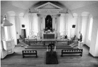
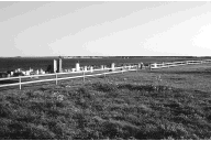
F. Cemeteries Parks Canada's management directive, "Human Remains, Cemeteries, and Grave Sites," provides direction for the management, treatment, maintenance and documentation of cemeteries and grave sites. As a general principle it states that all human remains, grave goods, cemeteries and grave sites will be treated with reverence, respect and dignity. The directive also states that management plans will address the preservation of grave markers and the identification of cemeteries and grave sites. Louisbourg has a number of cemeteries and burial areas. They range from the Rochefort Point and Kennington Cove cemeteries, which may contain upwards of 1,000 and 500 burials respectively, to miscellaneous burials of single individuals, such as those of Battery Island and Simon's Point. The archaeological collection includes human remains from three excavations. The archaeology unit maintains files and records for each of the cemeteries. The location of most of the cemeteries is known only from the historical record, and the precision of this information varies greatly. All burial locations are considered during environmental assessments and every precaution is taken to ensure that none are disturbed. Four of the burial locations have special characteristics:
Current actions and responsibilities for Site staff include: maintaining records and photos of each cemetery, periodic inspection and patrols and arrangement of any needed maintenance, conservation of stone markers using Parks Canada's conservation guidelines, replacement of wooden crosses as required, and the care of lawns and fences consistent with the standards set for day use areas in the Site. On its part, the parish applies standards and policies it uses for the other cemetery it manages outside the Site. These are used as a basis of discussion regarding the ongoing management of these cemeteries. Strategic Actions
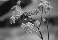
G. Natural Resources and Ecosystem Management In national historic sites, the prime mandate is to ensure commemorative integrity. Yet, there is a recognition that natural ecosystem features frequently form an integral part of the history and landscape of national historic sites. There is a need to ensure the protection of natural resources and ecosystem features consistent with the role of Parks Canada being an environmental steward. The cultural resource management principles of value provide policy direction for this role. This direction is based on an understanding that cultural resources, natural systems and people are highly interconnected. A holistic approach is essential to achieving a sustainable future. Historical Perspective Numerous modifications have occurred to the vegetation and landscape of the National Historic Site since the establishment of Louisbourg in the early 18th century. These include the construction of the Fortress itself, land clearing and modification for military purposes, animal grazing, cutting of timber for firewood, road and building construction, and introduction of non-native plant species. Some of the most substantial changes occurred in the 18th century when major cutting of the forests surrounding Louisbourg started in the 1720s for firewood, construction and military purposes. By the time of the second siege in 1758, almost all timber within 10 kilometres of the Fortress had been removed. Eastern hemlock and white pine were the preferred species and their removal accounts for their present-day rarity in the local area. The French modified the landscape immediately around the Fortress and along certain sections of the coast for defensive purposes. During both sieges the New Englanders and British left their imprint on the landscape through the construction of siege works and encampments.
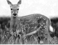
After the fall of Louisbourg, lands were cleared for agricultural purposes especially near the coast and in the interior along the roads. Remains of homes, farmsteads and fields are still visible. The remains of commercial use are still evident on the west side of Kennington Cove. Logging was extensive throughout the area over time. It is estimated that the Site has been cut 3 to 5 times since the early 18th century. Evidence from more recent mineral exploration in the Mineral Reserve Area can also be found. Clearly, past actions have had a major impact on the landscape one sees today. The relationship between the land and its resources, and the use made of them over time is an important consideration in understanding the natural environment of today. Resource Description Fortress of Louisbourg is one of the largest national historic sites in Canada with a 60 square kilometre land base and a 31 kilometre long coastline. The Site is characterized by undulating to rolling hills consisting of shallow soils over bedrock and interspersed by wetlands, bogs, brooks and streams. The coastline is mostly characterized by cliffs and rocky beaches with the exception being Kennington Cove where sandy beaches occur. The hydrology is typical of Nova Scotia coastal lowlands consisting of shallow lakes, ponds and brooks. The vegetation is predominately a boreal forest influenced by a maritime climate with cool summers, high rainfall and frequent fog. Three-quarters of the Site is forest covered with balsam fir and white spruce as dominant species. Wetlands, a result of glacial scouring and deposition, occupy about 10% of the landbase with bogs being the major type. Heathlands, commonly referred to as barrens, are located along the coast and occupy another 5% of the Site. Disturbed areas comprise about 8% and consist primarily of former areas that were settled or farmed. Mammal species are generally representative of those found on the southeastern portion of Cape Breton Island. The Site acts as a refuge for mammals, especially migrating deer, because of its protected status. Although the Site boundary is the mean high tide mark, there are marine resources worthy of note including seals, seabirds and ducks. The three islands located at the mouth of the harbour, one of which, Battery Island, is within the Site's boundaries, are nesting areas for gulls, cormorants, and guillemots. Inland, the avifauna closely resemble that present in Cape Breton Highlands National Park with high species diversity and low abundance. Fish habitat is primarily small slow-flowing brooks and shallow lakes that can become warm in summer. Of the varieties present, three are game species, Atlantic salmon, brook trout and rainbow smelt. Ecosystem-Based Planning The Resource Description and Analysis was completed in 1990. An interim Site Conservation Plan was completed in 1987 and updated in 1992. An Ecosystem Conservation Plan is now under way and will evolve from the former documents to address long-term natural and cultural resource concerns. The biophysical database stems from the mid-1970s. The vegetation cover, however, is updated from 1993 areal coverage. The database has been converted to digital form suitable for Geographic Information Systems. The use of the natural resource data in combination with digitized cultural resource data, is helpful to staff in identifying and analysing the interrelationships between the two and in taking the necessary actions to address threats. In this context, managing the natural environment can help to reinforce the commemorative integrity of the Site. Consistent with Cultural Resource Management policy, the completion of the database will lead to the identification of ecosystem features, habitat and species that are of special significance and worthy of protection as contributing to the diversity of the ecosystem of which they are a part. Research to date has identified the following special features. Vegetation About five percent of the landbase is heathland. Primarily located between Kennington Cove and White Point and east of Lighthouse Point, it extends along the coastline in an open rolling meadow-like strip providing a valued biological environment. The plant life clings to bedrock and shallow till and is strongly affected by the harsh marine environment. These salt tolerant, but stunted, plants are mainly Boreal with some Arctic-Alpine and Coastal Plain interspersed. Wetlands occupy approximately 10% of the landbase. Bogs are the most important type of wetland, especially raised bogs where hundreds of years of growth are evident. Characteristic bog vegetation is Arctic-Alpine with Boreal intermixed. Heathland and bogs have not been severely impacted over time by human activity and provide good opportunities for research purposes. Ten rare vascular plant species have already been identified based on Nova Scotia lists. One of these is also identified on the Federal list of rare plants. Others classed as rare, vulnerable and uncommon are under scrutiny because of favourable habitat. Most of these species are found in the bogs and heathland. Research is continuing with information being shared with provincial agencies. Wildlife Habitat Habitat within the Site boundaries helps to support two known species worthy of protection. The White-tailed deer and the Atlantic salmon are both listed as protected species under the National Parks Act (Part II, Section II). A well-known feature is the winter migration of the deer through the Site to yard in the coastal areas. There, the deer find shelter in the white spruce forest cover and have access to kelp, a main winter food source, where it washes up on shore. The numbers of deer fluctuate from year to year but they attract visitors interested in wildlife viewing. Atlantic salmon are present in three brooks, Kennington Cove, Freshwater and Gerratt. The last is a scheduled salmon stream. Parks Canada will protect the habitat that supports these species.
Kelly Lake Watershed Kelly Lake watershed is the water supply source for the community of Louisbourg and the National Historic Site. Part of the watershed is within the Site boundaries; the shoreline of the lake forms the boundary in this area. Parks Canada will continue to protect the watershed area within its boundaries to help prevent contamination of the water supply. Cooperative Ecosystem Management The landbase of the Site cannot be managed in isolation from the surrounding areas. Land use activities can have a direct impact on ecosystem features and processes resulting in a variety of stressors. Stresses can originate internally or externally. Internal ones can include visitor use and activities, construction projects, overfishing, possible mining exploration and extraction in the mineral reserve area, and intrusion of non-native plant species. External ones can include logging near the Site boundary, hunting, the construction of the Fleur-de-lis Trail and off-shore oil spills. To address these, there is a need to take an ecosystem perspective that includes acquiring information on natural and cultural resources, ecological processes, and human activities. This can only be achieved by working and cooperating with others in the local and regional area. There is a clear interdependency here among those involved. Site staff are already cooperating with others in the region to exchange information on the greater ecosystem including the provincial Department of Natural Resources particularly for deer population statistics, the provincial Department of the Environment, and the federal Departments of Fisheries and Oceans, and Environment including the Canadian Wildlife and Atmospheric Environment Services. In future, more local cooperation will be sought with adjacent land owners, University College of Cape Breton, the Fortress of Louisbourg Volunteers, the new regional municipality, fish and wildlife associations and naturalist groups. Cooperation will be accomplished through both formal and informal arrangements. To be successful, Parks Canada will have to demonstrate stewardship by undertaking research and monitoring programs to improve the current state of knowledge of the stresses affecting important ecosystem features. One of the first issues that needs to be addressed is the identification and evaluation of cultural resources. Their specific locations, condition and sensitivity are primary factors to consider when determining how the landbase will be managed. The Cultural Resource Management policy will take precedence in this context where cultural resources require protection. Any subsequent intervention into ecosystem processes will be carefully assessed before action is taken. Strategic Actions
|